Mapping with time rather than distance.
November 17, 2011 5:50 AM Subscribe
Time Maps maps the Netherlands based on how long it takes to reach a given destination rather than how far away it is.
We can reach almost any destination by train easily and relatively quick. In our busy lives we now think in time rather than distance[...]From the perspective of Eindhoven, for instance, the Netherlands is relatively small because of the quick and easy connections to other cities. At the same time, seen from a more remote and small village such as Stavoren the Netherlands is much bigger[...]At night the map will expand because there are no night trains and in the morning it will shrink once trains will commence their schedules. Here is a video demonstration.
We can reach almost any destination by train easily and relatively quick. In our busy lives we now think in time rather than distance[...]From the perspective of Eindhoven, for instance, the Netherlands is relatively small because of the quick and easy connections to other cities. At the same time, seen from a more remote and small village such as Stavoren the Netherlands is much bigger[...]At night the map will expand because there are no night trains and in the morning it will shrink once trains will commence their schedules. Here is a video demonstration.
After recovering from the initial contact with their site I recommend averting your eyes and clicking anywhere, the way the map of the Netherlands changes form depending on where you are is too cool to describe.
posted by hat_eater at 6:05 AM on November 17, 2011
posted by hat_eater at 6:05 AM on November 17, 2011
i used to ride that train
from Bologna up to Amsterdam...
posted by flapjax at midnite at 6:06 AM on November 17, 2011
from Bologna up to Amsterdam...
posted by flapjax at midnite at 6:06 AM on November 17, 2011
Love the concept, they should lose the Loony Toons graphics , though
posted by ouke at 6:07 AM on November 17, 2011
posted by ouke at 6:07 AM on November 17, 2011
Funny, I'm colorblind, and the site looks just fine to me.
posted by OmieWise at 6:10 AM on November 17, 2011
posted by OmieWise at 6:10 AM on November 17, 2011
At night the map will expand because there are no night trains and in the morning it will shrink once trains will commence their schedules.
When it snows, the Netherlands is bigger than Russia.
posted by three blind mice at 6:15 AM on November 17, 2011 [10 favorites]
When it snows, the Netherlands is bigger than Russia.
posted by three blind mice at 6:15 AM on November 17, 2011 [10 favorites]
I'd love to see someone do this for the UK. The vagaries of the train network here would create some serious distortion.
posted by Dysk at 6:15 AM on November 17, 2011
posted by Dysk at 6:15 AM on November 17, 2011
This is a neat idea, but seems to be kind of misleading for several reasons.
NL is only about 200 miles across. Not that I'm a fan of cars, but I can get anywhere within a 200 mile radius in 4 hours too and probably with more precision than the public transportation system. ("Precision" meaning "right to my final destination" vs "the nearest train station".) Public transportation has a lot to recommend it, but speed is not one of them.
posted by DU at 6:17 AM on November 17, 2011
Or I guess I should say "speed in the general case". For commuting, especially when most people do it, speed is definitely a feature. And "apparent speed" also counts. When I take my car, *I* have to do it for 4 hours. When I take a train, *I* am only in charge of the traveling for a few minutes (getting to and from the station). I can do whatever in the interim.
posted by DU at 6:18 AM on November 17, 2011
posted by DU at 6:18 AM on November 17, 2011
Just for perspective, practically nobody in the Netherlands will be happily driving for 4 hours, unless it's a holiday destination. Maybe an hour's drive (and already then you're beginning to think: should I move closer? You'll probably get some kind of compensation for driving this long), if you're unlucky, 2 hours.
By the way, this also shows very clearly that the Afsluitdijk is an obstacle, and public transport such as trains have to take the long way around, going south of the IJselmeer, through the busiest part of the country.
Originally, I believe, there was supposed to be a railway over the Afsluitdijk as well, but that never happened. The fastest public transport from Groningen to Noord-Holland is some combination that involves taking a bus over the dyke.
(Of course, Groningen, Friesland and the north of Noord-Holland are generally considered an economic wasteland by the government in Den Haag and the rest of the Randstad)
posted by Harry at 6:39 AM on November 17, 2011
Not really the same thing, but a similar theme: Triptrop NYC shows how long it takes to get anywhere in the city from a specific address. By mefi's own soma lkzx.
posted by desjardins at 6:44 AM on November 17, 2011 [1 favorite]
posted by desjardins at 6:44 AM on November 17, 2011 [1 favorite]
Also, yay maps!
posted by desjardins at 6:44 AM on November 17, 2011
posted by desjardins at 6:44 AM on November 17, 2011
I recommend the cheat (aka Video Demonstration link) for the age challenged.
Meanwhile: we're WAY beyond pie charts here. This is very clever, seriously down the road to useful.
posted by victors at 6:45 AM on November 17, 2011
Meanwhile: we're WAY beyond pie charts here. This is very clever, seriously down the road to useful.
posted by victors at 6:45 AM on November 17, 2011
NL is only about 200 miles across. Not that I'm a fan of cars, but I can get anywhere within a 200 mile radius in 4 hours too and probably with more precision than the public transportation system. ("Precision" meaning "right to my final destination" vs "the nearest train station".) Public transportation has a lot to recommend it, but speed is not one of them.
DU, do you live in Europe? I can tell you in my experience that North American car travel times do not work in central England. It can take an hour to drive 15 miles in the UK without any traffic.
posted by srboisvert at 6:55 AM on November 17, 2011 [3 favorites]
DU, do you live in Europe? I can tell you in my experience that North American car travel times do not work in central England. It can take an hour to drive 15 miles in the UK without any traffic.
posted by srboisvert at 6:55 AM on November 17, 2011 [3 favorites]
This is how we've always measured travel in Texas in my experience. "How far is it to Dallas?" "Three and a half hours, four and a half if the construction by Hillsboro is bad."
posted by immlass at 6:57 AM on November 17, 2011
posted by immlass at 6:57 AM on November 17, 2011
Though there have been points in history when the distance was fixed by edict, the traditional Chinese measure of distance, the li, famously varied by the actual practicalities of travel.
posted by Abiezer at 7:35 AM on November 17, 2011
posted by Abiezer at 7:35 AM on November 17, 2011
I've made a screen shot of the current traffic situation in the west of the netherlands and uploaded it to my weblog - a live version is here in case you're reading this at any time during dutch rush hour. It's 16:48 right now.
This should give you a hint why public transport is valued a lot by people over here...
posted by DreamerFi at 7:52 AM on November 17, 2011 [2 favorites]
This should give you a hint why public transport is valued a lot by people over here...
posted by DreamerFi at 7:52 AM on November 17, 2011 [2 favorites]
Since 1983, the meter itself has been defined in terms of time -- the distance light can travel in a certain fraction of a second.
posted by ubiquity at 7:58 AM on November 17, 2011
posted by ubiquity at 7:58 AM on November 17, 2011
- The rod is a historical unit of length equal to 5½ yards. It may have originated from the typical length of a mediaeval ox-goad.
- The furlong (meaning furrow length) was the distance a team of oxen could plough without resting. This was standardised to be exactly 40 rods.
- An acre was the amount of land tillable by one man behind one ox in one day. Traditional acres were long and narrow due to the difficulty in turning the plough.
- An oxgang was the amount of land tillable by one ox in a ploughing season. This could vary from village to village, but was typically around 15 acres.
- A virgate was the amount of land tillable by two oxen in a ploughing season.
- A carucate was the amount of land tillable by a team of eight oxen in a ploughing season. This was equal to 8 oxgangs or 4 virgates.
Great post, thanks! The key thing here is the map distortion where distances are times, not geographic distance. Some other versions of this idea:
Japan Travel-Time Map by Kohei Sugiura, also color version. I believe this dates to the 1960s or 70s.
Roundup of travel time maps, including a really nice 2007 NY subway map from the New York Times.
Eric Fisher's recent Muni travel time and taxi travel time cartograms, for San Francisco. These are interesting in that they somehow represent the whole city, not just travel time from one chosen spot. I don't quite understand it.
posted by Nelson at 10:39 AM on November 17, 2011 [1 favorite]
Japan Travel-Time Map by Kohei Sugiura, also color version. I believe this dates to the 1960s or 70s.
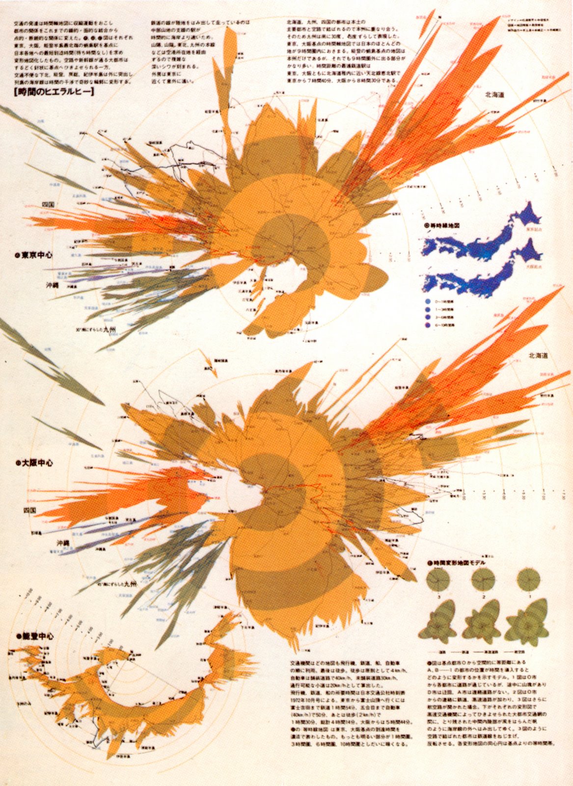
Roundup of travel time maps, including a really nice 2007 NY subway map from the New York Times.
Eric Fisher's recent Muni travel time and taxi travel time cartograms, for San Francisco. These are interesting in that they somehow represent the whole city, not just travel time from one chosen spot. I don't quite understand it.
posted by Nelson at 10:39 AM on November 17, 2011 [1 favorite]
Not that I'm a fan of cars, but I can get anywhere within a 200 mile radius in 4 hours too and probably with more precision than the public transportation system.
Doesn't all the road traffic get bogged down around Arnhem? Isn't that what happened during Market Garden?
posted by TheWhiteSkull at 11:17 AM on November 17, 2011 [1 favorite]
Doesn't all the road traffic get bogged down around Arnhem? Isn't that what happened during Market Garden?
posted by TheWhiteSkull at 11:17 AM on November 17, 2011 [1 favorite]
the distance light can travel in a certain fraction of a second
...in vacuum.
Sorry for the nitpick, but given the subject it's doubly relevant.
posted by hat_eater at 11:19 AM on November 17, 2011
...in vacuum.
Sorry for the nitpick, but given the subject it's doubly relevant.
posted by hat_eater at 11:19 AM on November 17, 2011
Look man, I just moved back after 13 years, and I still can't get my head around this new chip system. I mean, I can fucking bike to A'dam from Haarlem faster than I can navigate the financial transaction around getting a NS ticket. Coins? Really? Grrrrrrrrrr.
I am disappoint.
posted by digitalprimate at 11:23 AM on November 17, 2011
I am disappoint.
posted by digitalprimate at 11:23 AM on November 17, 2011
NL is only about 200 miles across. Not that I'm a fan of cars, but I can get anywhere within a 200 mile radius in 4 hours too and probably with more precision than the public transportation system. ("Precision" meaning "right to my final destination" vs "the nearest train station".) Public transportation has a lot to recommend it, but speed is not one of them.
As well as reflecting US road systems (as srboisvert said), this also ignores high-speed rail. Paris to Marseilles is a bit less than 500 miles and takes 3 hours by TGV, which is an average of over 160 mph. Then you've got integrated transport systems, which mean that when your train arrives at the station, there's often a bus waiting right outside to take you on to your final destination or a protected cycle rack where you can pick up your bike for a pleasant ride along dedicated cycle lanes.
Now, as someone who grew up in the British countryside I'm well aware that rail and integrated transport don't exist for everyone, but neither is it true that speed to final destination is always better with cars. Totally agree with your point about "apparent speed", though.
Also, fantastic post, OmieWise!
posted by Busy Old Fool at 2:22 PM on November 17, 2011
NL is only about 200 miles across. Not that I'm a fan of cars, but I can get anywhere within a 200 mile radius in 4 hours too and probably with more precision than the public transportation system.
I can assure you, drive for four hours in the Netherlands during the day, and not only will you probably not have done anything like 200 miles, but you'll probably go postal.
posted by Skeptic at 3:11 PM on November 17, 2011 [1 favorite]
I can assure you, drive for four hours in the Netherlands during the day, and not only will you probably not have done anything like 200 miles, but you'll probably go postal.
posted by Skeptic at 3:11 PM on November 17, 2011 [1 favorite]
What I don't understand is, why are all those Dutch people driving between cities in the Netherlands? Don't they know there are trains?!
Mind you, the corridor between Venlo and Antwerp is the part with which I'm the most familiar. That road is loaded with traffic particularly because there is no rail following that path. If you want to get between Duesseldorf/Duisburg and Antwerp, car beats the train by far. For all the wonder of trains, they're limited by the rails.
posted by Goofyy at 4:18 AM on November 18, 2011
"In our busy lives we now think in time rather than distance"
Thinking this way is a function of many possible situations. We already do this when crossing great distances. For example, most of us already say it takes 6-8 hours to travel across the Atlantic, depending on where we start and where we land.
And in areas where people travel great distances over complicated routes, most people use the travel time to talk about the trip rather than the rather meaningless distances we can measure on a map or route.
In Canada, I've never heard anyone use any other way of describing, say, going across Northern Ontario into Quebec or Manitoba or across the Rockies. Unless specifically queried about the distance in kilometres.
posted by clvrmnky at 9:27 AM on November 18, 2011
« Older Gabrielle Giffords, Broca's area and song therapy | face to face Newer »
This thread has been archived and is closed to new comments
posted by hat_eater at 6:01 AM on November 17, 2011 [3 favorites]