Old Maps of New Jersey
February 10, 2012 3:18 PM Subscribe
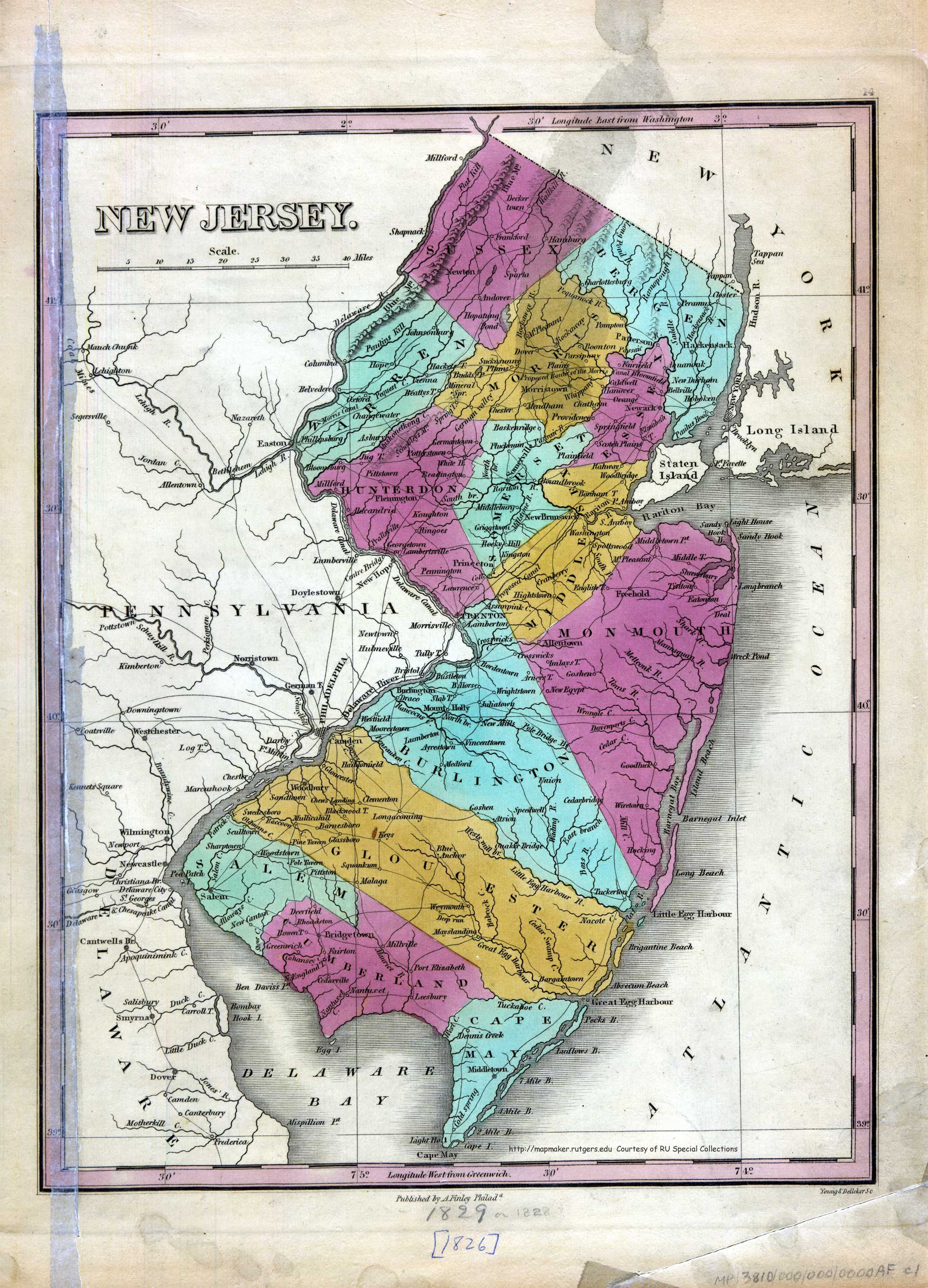
Here are some old New Jersey maps, available online. Take a look at this map of southern New Jersey made by Dutch settlers in 1669. The Dutch labeled Cape May "Cabo May." Take a look at Delaware Bay. The Dutch called it Godyn's Bay. This 1709 map shows a division between east and west New Jersey. Probably most interesting of all is this map from 1795. Here, you can see archaic names of towns. What is now Pennington was once called "Pennytown." Lawrenceville was once called "Maidenhead." What is today called Hightstown was once called "Hiatstown." How about that little island off the southwestern New Jersey coast, Egg Island? Is that even there anymore?
You can see my house from here (or at least the one I grew up in)
posted by octothorpe at 3:39 PM on February 10, 2012
posted by octothorpe at 3:39 PM on February 10, 2012
The city I was born and raised in, Rahway, was once called Spanktown because an early settler publicly took his spouse across his knee and chastised her.
posted by defenestration at 3:41 PM on February 10, 2012 [4 favorites]
posted by defenestration at 3:41 PM on February 10, 2012 [4 favorites]
So what was that road from Asbury Park to Holmdel called when my great great grandpappy had to walk uphill both ways to school in the snow with his shoes that had holes in 'em?
posted by bukvich at 3:46 PM on February 10, 2012
posted by bukvich at 3:46 PM on February 10, 2012
Wow! What a fantastic story about Rahway. New Jersey has a lot of history.
posted by candasartan at 3:57 PM on February 10, 2012
posted by candasartan at 3:57 PM on February 10, 2012
This is WONderful, thanks. Monmouth County represent. Fascinating stuff.
posted by Miko at 5:50 PM on February 10, 2012 [2 favorites]
posted by Miko at 5:50 PM on February 10, 2012 [2 favorites]
Interesting quirk of New Jersey history: when NJ was divided into West Jersey and East Jersey, and then united again, there was a group of people who still evinced "West Jersey consciousness" and this was apparently a political problem.
I was fascinated to discover this. If anything, today we have North and South Jersey consciousness. Being from Red Bank, we were always at pains to tell outsiders we were from "Central Jersey." I have found that the only people who make a distinction about "Central Jersey" are people from Central Jersey who don't consider that region to be part of either North or South Jersey. There's a decent argument for it - the particular mix of historical conditions that made the North end of the Shore what it is didn't work the same way in other parts of the state. But it is dicing pretty finely.
Here's a beautiful map of my hometown, streets I walked and still walk by instinct when I visit and in my dreams when away. The street I grew up on is here, but was all farms; my home wouldn't be built for another 50 years, nor would my school. But I walked the same streets and in fact, shopped in many of the stores depicted here, and knew many families who bore these names. Lots of those families are still there.
posted by Miko at 5:57 PM on February 10, 2012 [1 favorite]
Miko, as a mostly lifelong central Jerseyan, your words ring true. I've always thought central Jersey can be defined by the overlap of the area considered south Jersey by north Jerseyans and north Jersey by south Jerseyans. I admit, though, this takes the defining out of the hands of central Jerseyans, which is problematic.
posted by mollweide at 6:18 PM on February 10, 2012 [1 favorite]
posted by mollweide at 6:18 PM on February 10, 2012 [1 favorite]
There's something to be said for that approach, though. It's being otherized by both regions at once that sort of helps make Central Jersey.
posted by Miko at 6:22 PM on February 10, 2012
posted by Miko at 6:22 PM on February 10, 2012
I agree, but yet it somehow seems wrong to cede them the (rhetorical?) space.
And, for the record, Pennington was Queenstown before it was anything else. Turns out the name wasn't so popular after the revolution. I guess nearby Princeton already had too much invested in the name to change.
posted by mollweide at 6:43 PM on February 10, 2012 [1 favorite]
And, for the record, Pennington was Queenstown before it was anything else. Turns out the name wasn't so popular after the revolution. I guess nearby Princeton already had too much invested in the name to change.
posted by mollweide at 6:43 PM on February 10, 2012 [1 favorite]
Flemingtown has become Flemington by 1826 but it's "Georgetown or Lambertsville"
posted by TWinbrook8 at 7:04 PM on February 10, 2012
posted by TWinbrook8 at 7:04 PM on February 10, 2012
Thanks for this. I grew up in Medford Lakes, which, to look at a map, seems central-ish. We always considered ourselves part of South Jersey (capital "S"), though, without question. Right around the border between strip malls and pine barrens, I think we decided we'd rather identify with the cedar water, sandy soil, dwarf forests, and weirdos.
posted by intendedeffect at 7:29 PM on February 10, 2012 [2 favorites]
posted by intendedeffect at 7:29 PM on February 10, 2012 [2 favorites]
Oh yeah, Medford Lakes is way South Jersey. I can't imagine including that in Central Jersey at all.
posted by Miko at 7:31 PM on February 10, 2012
posted by Miko at 7:31 PM on February 10, 2012
On reflection I think maybe a good "South Jersey" dividing line is Route 195. But it might fall even a little north of that.
posted by Miko at 7:35 PM on February 10, 2012
posted by Miko at 7:35 PM on February 10, 2012
Wonder when Belford came into existence; it not in any of the old maps of Monmouth County.
posted by Renoroc at 7:55 PM on February 10, 2012
posted by Renoroc at 7:55 PM on February 10, 2012
I am missing a plug-in, but it doesn't tell me what plug-in I'm missing. I'm using Chrome on Win 7.
posted by desjardins at 8:10 PM on February 10, 2012
posted by desjardins at 8:10 PM on February 10, 2012
I can't believe there's an individual map for the tiny town I grew up in, Spotswood!
I never knew there was a distillery there.
These are all too cool.
posted by rachaelfaith at 8:24 PM on February 10, 2012
I never knew there was a distillery there.
These are all too cool.
posted by rachaelfaith at 8:24 PM on February 10, 2012
I'd say central Dips below 195 in places, or at least Toms River doesn't really feel like south Jersey to me.
posted by mollweide at 9:23 PM on February 10, 2012 [1 favorite]
posted by mollweide at 9:23 PM on February 10, 2012 [1 favorite]
I admit, though, this takes the defining out of the hands of central Jerseyans, which is problematic.
You've got a point, but... "central Jerseyans", amirite? Know what I mean?
Sussex County, representin'.
posted by codswallop at 2:06 AM on February 11, 2012
You've got a point, but... "central Jerseyans", amirite? Know what I mean?
Sussex County, representin'.
posted by codswallop at 2:06 AM on February 11, 2012
No, codswallop, I don't. You Sussexers are practically furriners to us central Jersey types. Although, judging from what I see when I visit my brother-in-law in Sparta, it looks like you might be aiming for a central-Jersey-with-hills sort of look these days.
posted by mollweide at 7:33 AM on February 11, 2012
posted by mollweide at 7:33 AM on February 11, 2012
Where are the turnpike exits? Or, for that matter, the Vince Lombardi rest stop? (although, that may one day be renamed the Pottery Barn rest stop
posted by Duck_Lips at 7:39 AM on February 11, 2012
posted by Duck_Lips at 7:39 AM on February 11, 2012
I think the story about Rahway being called Spanktown may be apocryphal because, in this map from 1776, Spanktown and Rahway are listed next to each other. Maybe Spanktown was just a nearby location that had a name change.
Pennington may have changed from its oldest name, Queenstown, to Pennytown because the queen was pictured on the face of a penny at the time. This is just a guess. Does anyone have any more information on this?
posted by candasartan at 9:22 AM on February 11, 2012
Pennington may have changed from its oldest name, Queenstown, to Pennytown because the queen was pictured on the face of a penny at the time. This is just a guess. Does anyone have any more information on this?
posted by candasartan at 9:22 AM on February 11, 2012
I look into it, candasartan. My grandmother has edited a couple of books about Rahway.
Off the top of my head, I remember that parts of what is all Rahway now had different names, then at some point, they all took the name Rahway. Something like that. But that may be unrelated to the Spanktown thing.
posted by defenestration at 6:36 PM on February 11, 2012
Off the top of my head, I remember that parts of what is all Rahway now had different names, then at some point, they all took the name Rahway. Something like that. But that may be unrelated to the Spanktown thing.
posted by defenestration at 6:36 PM on February 11, 2012
parts of what is all Rahway now had different names, then at some point, they all took the name Rahway
That's completely common - crossroads villages with their own names and identities often got subsumed into larger cities as they grew. I bet Spanktown was a real place that just got drawn into Rahway.
posted by Miko at 7:17 PM on February 11, 2012
That's completely common - crossroads villages with their own names and identities often got subsumed into larger cities as they grew. I bet Spanktown was a real place that just got drawn into Rahway.
posted by Miko at 7:17 PM on February 11, 2012
That west va east jersey thing would really help with the whole thing where west Hersey doesn't have exits you idiot.
posted by smackfu at 4:13 PM on February 12, 2012
posted by smackfu at 4:13 PM on February 12, 2012
« Older Holy moving pictures, Batman! | Kickstarted Newer »
This thread has been archived and is closed to new comments
posted by theartandsound at 3:32 PM on February 10, 2012 [2 favorites]