Bringing water back to light
August 2, 2013 6:12 AM Subscribe
A hundred years ago streams got in the way of urban planning so people covered them up. Today towns and cities are looking to bring these streams back into light thus reducing flood risks, improving water quality, and revitalising neighbourhoods.
Toronto just got a nasty lesson about this -- much of our recent flooding was Garrison Creek pointing out that it still exists, thank you very much.
The pictures in that first link are gorgeous, even if what they represent is non-awesome.
posted by jacquilynne at 6:29 AM on August 2, 2013 [4 favorites]
The pictures in that first link are gorgeous, even if what they represent is non-awesome.
posted by jacquilynne at 6:29 AM on August 2, 2013 [4 favorites]
We had a not-learned-lession in this last year . Plenty of the damage was from creeks and streams that have been culverted over to the point I had no idea there where there. Disappeared waterways. Of course the reconstruction has just paved it over all again. Some lesions have to be pounded in with a ball-peen hammer I guess.
posted by edgeways at 6:45 AM on August 2, 2013 [1 favorite]
posted by edgeways at 6:45 AM on August 2, 2013 [1 favorite]
As someone who recently rode a bike through the Garrison Creek as it was running down Davenport, I would like to see some interesting solutions to reviving urban waterways in Toronto, that would also help with flood control. We think of Toronto as being split by the Don and the Humber, but there were originally a number of other waterways running down to the lake. Could Toronto one day look like Bruges or Amsterdam?
(Of course, at this point we can't even fix the roads or build an LRT, so I'm not holding my breath)
posted by TheWhiteSkull at 7:09 AM on August 2, 2013
(Of course, at this point we can't even fix the roads or build an LRT, so I'm not holding my breath)
posted by TheWhiteSkull at 7:09 AM on August 2, 2013
Stunning photos, and the Daylighting Streams report is a good read.
But why are all these streams covered at all? Flash back more than a hundred years. In many urban areas around the world, small streams were just getting in the way. You couldn't build on top of them, and the rapidly growing populations in many cities were throwing all their sewage into open water.
Often, engineers found that the simplest solution was to bury the streams, routing the water into pipes and paving over the top. In Yonkers, "the Army Corps of Engineers put a parking lot on top of it, which everybody thought was progress," Mitroff said.
It's so interesting to see the motivations behind some of these decisions. They seem (and ultimately were) short-sighted, but it does well to remember that wastewater treatment wasn't terribly popular in the 1800's (didn't exist in NYC until the late 1800's and even is lacking today in many places, for example, Newfoundland/Labrador in Canada). It kind of cuts you short from singing Big Yellow Taxi, since it was far from paradise at the time.
Now that more sewage infrastructure exists, I'd love to see more daylighting.
posted by Paper rabies at 7:13 AM on August 2, 2013 [1 favorite]
Even in (relatively) new cities like Tulsa, we have buried streams. Several of them, actually. Some of their tunnels are quite large. A couple of them have had segments daylighted, but only to build water features for parks. At some point they're supposed to be tearing up a street and turning the creek that runs under it into a canal. Like we're Venice or something. (I actually like the idea)
posted by wierdo at 7:40 AM on August 2, 2013 [1 favorite]
posted by wierdo at 7:40 AM on August 2, 2013 [1 favorite]
One of the weirdest experiences I had on moving to the neighborhood I live in now was looking at the natural water features and realizing that over the years the water management bureaucrats had redug them into a set of drainage canals that all follow a rigged up zig zagging Cartesian grid. The geologically aged Spring Branch is now a concrete banked drainage ditch that goes in a straight line until at a certain point it takes a ninety degree angle.
The guys who did this spent a lot of money and time and labor and they considered it progress.
posted by bukvich at 7:46 AM on August 2, 2013
The guys who did this spent a lot of money and time and labor and they considered it progress.
posted by bukvich at 7:46 AM on August 2, 2013
All those covered rivers, but the all-concrete L.A. River is open-air?
posted by Sys Rq at 7:49 AM on August 2, 2013
posted by Sys Rq at 7:49 AM on August 2, 2013
Kalamazoo was a shock to me after ten years away, and the downtown is actually a pleasant place to be now. Nice to see it mentioned in the NGeo article.
posted by Ghidorah at 8:07 AM on August 2, 2013
posted by Ghidorah at 8:07 AM on August 2, 2013
All those covered rivers, but the all-concrete L.A. River is open-air?
Looking at the topology, it seems impossible to safely cover the L.A. River at a reasonable cost. Basically, this a stream that's normally quiescent, but during the winter rains, can carry an extremely high level of water. Trying to contain that in a underground tunnel would be very hard, so instead, they built a ditch.
St. Louis has a similar ditched river, the River Des Peres*, but the reason for the level change is different. In this case, it's backflooding from the the Mississippi River that causes the large change in water volume in the river, the river itself drains a very small amount of land.
* AKA the River Despair
posted by eriko at 8:12 AM on August 2, 2013 [4 favorites]
That's cool. A stream in Nashville is being daylighted to add a water feature to a park, but I didn't realize it was a thing.
posted by ghharr at 8:17 AM on August 2, 2013
posted by ghharr at 8:17 AM on August 2, 2013
I knew it was over between an old boyfriend and me when I took him to Strawberry Creek Park in Berkeley, ecstatic that at least part of the creek had been daylighted, and he spent the entire time sulking that the rest of the creek was still under concrete.
posted by corey flood at 8:29 AM on August 2, 2013 [2 favorites]
posted by corey flood at 8:29 AM on August 2, 2013 [2 favorites]
There is an excellent recent documentary which looks at several "lost rivers" around the world, including two which have since been day lighted (in Seoul and Yonkers). It was also very prescient about the flooding and raw sewage problems in Toronto this past month.
posted by jb at 8:40 AM on August 2, 2013 [1 favorite]
posted by jb at 8:40 AM on August 2, 2013 [1 favorite]
eriko, you forgot to mention the unique odor of the River Des Peres. I have actually used that stench to navigate a few times, if only by noting that the intensity of stink was loosely correlated to the tangential/wind distance to that most awful set of line segments to be denoted as a "river."
posted by adipocere at 8:56 AM on August 2, 2013
posted by adipocere at 8:56 AM on August 2, 2013
Great post! My final report (AKA thesis) for my master's degree in community and regional planning was titled Flood Control in Urban Stream Corridors. Back then, daylighting wasn't a term I was aware of but I really like the idea. Thanks for this.
posted by misskaz at 9:04 AM on August 2, 2013
posted by misskaz at 9:04 AM on August 2, 2013
All those covered rivers, but the all-concrete L.A. River is open-air?
There's a big push to return sections of the LA river to a quasi "natural" state. There was an interesting new proposal along those lines for one section of it in today's LA Times.
posted by yoink at 9:30 AM on August 2, 2013
There's a big push to return sections of the LA river to a quasi "natural" state. There was an interesting new proposal along those lines for one section of it in today's LA Times.
posted by yoink at 9:30 AM on August 2, 2013
Previously, about Seoul's Cheonggyecheon Restoration Project. I also like that they left up some freeway supports as a reminder that a highway once covered the river.
posted by mcmile at 10:57 AM on August 2, 2013
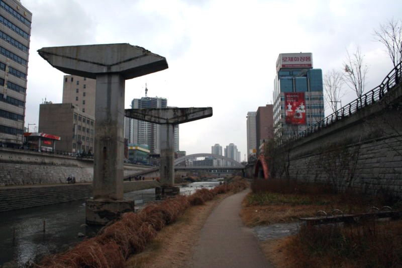
posted by mcmile at 10:57 AM on August 2, 2013
The next time you hear someone despair about global warming; tell them about their local creek that's probably buried under a nearby street. Reviving these sub-urban waterways seems like the ideal mid-scale point to translate the now pervasive environmental inclination into local long term political will that could - in aggregate - make a big difference.
Here in San Francisco, we have one incredibly beautiful free flowing creek left. There are a number of other creeks still flowing under San Francisco's streets. To pick just one: Napoleon Street was built on Islais creek. They recently re-leveled it but it gradually sinks into the still flowing creek beneath it leaving it with a "u" shape (a good tell tale sign to look for if you wish to become an urban creek archeologist).
Somewhere between buying organic at Whole Foods and pointing the global-warming-blame-finger at abstract corporate entities is a local movement that prioritizes raising these buried waterways. Again, in my local example, if the oil tar of Napoleon Street were lifted off the back of Islais creek you could put walkways aside it with foot bridges over a nice natural corridor. Convert the adjacent warehouses to restaurants and shops and you have a harmonious hybrid foot centric new eco-friendly neighborhood center. Thanks for the great post!
posted by astrobiophysican at 11:22 AM on August 2, 2013 [3 favorites]
There are a lot of covered streams in Philadelphia; there's a good (though not recently updated) site about them at phillyh2o.org & some descriptions of Gunner's Run, which became the Aramingo Canal, which became Aramingo Avenue over here.
posted by zempf at 11:34 AM on August 2, 2013
posted by zempf at 11:34 AM on August 2, 2013
Austin is going to bury a mile of Waller creek in downtown ( some 24 acres of development ensues ); but turn the ?re-surfacing? of it downstream into a park.
posted by buzzman at 5:19 PM on August 2, 2013
posted by buzzman at 5:19 PM on August 2, 2013
A lot of the damage in the Christchurch earthquake was buildings located on top of long-buried streams.
posted by xiw at 4:04 AM on August 3, 2013
posted by xiw at 4:04 AM on August 3, 2013
« Older What Kind Of A Noise Annoys An Oyster? | It's Not Time to Worry Yet Newer »
This thread has been archived and is closed to new comments
At 1147 feet, the Crawford Street Bridge over the Providence River in Providence was qualified by the Guinness Book of World Records as the widest bridge in the world. Having grown from several normal-sized bridges between 1843 and 1940, the decking was dismantled in the early 1990s as part of a downtown revitalization plan.
Providence, you are ahead of the trend for a change!
From what I understand, the old downtown was pretty grim in the 60s and 70s....
posted by GenjiandProust at 6:17 AM on August 2, 2013