Nobody lives here.
April 21, 2014 7:11 AM Subscribe
Nik Freeman has created a map, based on census data, to illustrate the 47% of the United States where nobody lives.
I wish we could zoom in. It would be nice to find the places near me where no one lives.
posted by GenjiandProust at 7:17 AM on April 21, 2014 [8 favorites]
posted by GenjiandProust at 7:17 AM on April 21, 2014 [8 favorites]
It's funny how even the pattern of uninhabitedness of North Dakota is. You can pretty much see the shape of the state, which makes one wonder what the distinguishing political, legal or administrative characteristic of that state is that brings it about.
posted by George_Spiggott at 7:19 AM on April 21, 2014 [6 favorites]
posted by George_Spiggott at 7:19 AM on April 21, 2014 [6 favorites]
People live in Idaho? Wait, is Idaho real? Have I been lied to about Idaho?
posted by chasing at 7:24 AM on April 21, 2014 [4 favorites]
posted by chasing at 7:24 AM on April 21, 2014 [4 favorites]
To be fair, those were where all the people who were carried up rapture lived.
posted by Nanukthedog at 7:25 AM on April 21, 2014 [7 favorites]
posted by Nanukthedog at 7:25 AM on April 21, 2014 [7 favorites]
Very cool. Thanks for posting this.
posted by Tell Me No Lies at 7:26 AM on April 21, 2014
posted by Tell Me No Lies at 7:26 AM on April 21, 2014
I wonder how much of that land is Federal or state parks?
posted by Ambient Echo at 7:26 AM on April 21, 2014 [1 favorite]
posted by Ambient Echo at 7:26 AM on April 21, 2014 [1 favorite]
illustrate the 47% of the United States where nobody lives.
Somewhere, someone on the Romney campaign team reads this and wishes they'd been able to hand waive this number away saying this is what the failed candidate meant.
posted by MCMikeNamara at 7:28 AM on April 21, 2014 [21 favorites]
Somewhere, someone on the Romney campaign team reads this and wishes they'd been able to hand waive this number away saying this is what the failed candidate meant.
posted by MCMikeNamara at 7:28 AM on April 21, 2014 [21 favorites]
Northern Maine really pops out in that map. It's so strikingly unpopulated that you can discern the US/Canada border even with labels turned off.
posted by theodolite at 7:32 AM on April 21, 2014 [2 favorites]
posted by theodolite at 7:32 AM on April 21, 2014 [2 favorites]
I wonder how much of that land is Federal or state parks?
A fair amount is also military bases -- that big solid-green block where New Mexico turns into Texas (right above where the US-Mexico border turns from a straight east-west to a straight southeast-northwest line) is Fort Bliss, which is huuuge and mostly artillery landing sites and tank runs.
posted by Etrigan at 7:36 AM on April 21, 2014 [1 favorite]
This map must be wrong. I distinctly remember being told that we are overrun with immigrants.
posted by East Manitoba Regional Junior Kabaddi Champion '94 at 7:36 AM on April 21, 2014 [9 favorites]
posted by East Manitoba Regional Junior Kabaddi Champion '94 at 7:36 AM on April 21, 2014 [9 favorites]
I wonder how much of that land is Federal or state parks?
In the west, a lot of it is federal. This map (pdf; from here) gives a sense of the scale of federal ownership in the west, especially the intermountain west.
I'd be curious how much of Maine's empty areas are public, and how much are owned by logging companies.
It would be fun to play with this as a GIS layer, to see how depopulated areas intersect with ownership, land cover, and transportation. The anomalies might be the most interesting -- depopulated areas next to cities, say, or that used to have population in a previous census.
posted by Dip Flash at 7:37 AM on April 21, 2014 [6 favorites]
Apologies for being thick, but I scanned TFA and couldn't find an answer: are these places places where literally no one lives, or places where population is at some negligible amount such that "practically" no one lives there?
posted by DirtyOldTown at 7:39 AM on April 21, 2014
posted by DirtyOldTown at 7:39 AM on April 21, 2014
The USA ranks 179th for population density, having one-eighth that of the UK
posted by East Manitoba Regional Junior Kabaddi Champion '94 at 7:40 AM on April 21, 2014 [1 favorite]
posted by East Manitoba Regional Junior Kabaddi Champion '94 at 7:40 AM on April 21, 2014 [1 favorite]
Apologies for being thick, but I scanned TFA and couldn't find an answer: are these places places where literally no one lives, or places where population is at some negligible amount such that "practically" no one lives there?
A single person is enough.
posted by Tell Me No Lies at 7:42 AM on April 21, 2014
A single person is enough.
posted by Tell Me No Lies at 7:42 AM on April 21, 2014
I'd be curious how much of Maine's empty areas are public, and how much are owned by logging companies.
That's nearly all logging company land except for Baxter State Park (scroll down that page for a map)
posted by briank at 7:43 AM on April 21, 2014 [1 favorite]
That's nearly all logging company land except for Baxter State Park (scroll down that page for a map)
posted by briank at 7:43 AM on April 21, 2014 [1 favorite]
Apologies for being thick, but I scanned TFA and couldn't find an answer: are these places places where literally no one lives, or places where population is at some negligible amount such that "practically" no one lives there?
Literally:
Literally:
Of them, 4,871,270 blocks totaling 4.61 million square kilometers were reported to have no population living inside them.posted by Etrigan at 7:43 AM on April 21, 2014
(And honestly, it's the second paragraph.)
posted by Tell Me No Lies at 7:43 AM on April 21, 2014 [6 favorites]
posted by Tell Me No Lies at 7:43 AM on April 21, 2014 [6 favorites]
The unpopulated areas of North Carolina are hideous swamplands.
posted by sonic meat machine at 7:45 AM on April 21, 2014 [1 favorite]
posted by sonic meat machine at 7:45 AM on April 21, 2014 [1 favorite]
The middle of Pennsylvania is pretty impressive. Driving on I-80 through there is an experience- there's quite a few places along there where the only sign of people is the road, and maybe a cell tower in the distance. Tina Fey has a nice bit in Bossypants talking about the "joys" of doing that road trip with a small child- basically, your pit stop options in the middle of the state are Hazelton, Clearfield, or Du Bois, and that's it.
posted by damayanti at 7:45 AM on April 21, 2014 [3 favorites]
posted by damayanti at 7:45 AM on April 21, 2014 [3 favorites]
People live in Idaho? Wait, is Idaho real? Have I been lied to about Idaho?
To be precise, it's a collection of private Idahos.
posted by tommasz at 7:49 AM on April 21, 2014 [23 favorites]
To be precise, it's a collection of private Idahos.
posted by tommasz at 7:49 AM on April 21, 2014 [23 favorites]
I wish we could zoom in. It would be nice to find the places near me where no one lives.
THERE ARE HOT EMPTY SPACES IN YOUR AREA!
posted by brundlefly at 7:51 AM on April 21, 2014 [21 favorites]
THERE ARE HOT EMPTY SPACES IN YOUR AREA!
posted by brundlefly at 7:51 AM on April 21, 2014 [21 favorites]
The fact that it uses Census blocks which are really variable in size, along with "any population," makes it kind of vaguely confusing; the areas of Alaska that aren't green could either represent one homestead parked in the middle of nowhere or a huge sprawling semi-urban area (which is a thing that does exist there).
posted by psoas at 7:51 AM on April 21, 2014 [2 favorites]
posted by psoas at 7:51 AM on April 21, 2014 [2 favorites]
In the west, a lot of it is federal. This map (pdf; from here) gives a sense of the scale of federal ownership in the west, especially the intermountain west.
Actually Cliven Bundy's family has owned it since umpteen-umpty-three and has a piece of parchment signed by Benjamin Lincoln to prove it around here somewhere....
posted by George_Spiggott at 7:52 AM on April 21, 2014 [8 favorites]
Actually Cliven Bundy's family has owned it since umpteen-umpty-three and has a piece of parchment signed by Benjamin Lincoln to prove it around here somewhere....
posted by George_Spiggott at 7:52 AM on April 21, 2014 [8 favorites]
Northern Maine really pops out in that map. It's so strikingly unpopulated that you can discern the US/Canada border even with labels turned off.
That's nearly all logging company land except for Baxter State Park (scroll down that page for a map)
Yeah if you zoom in on that google map link, the forest is almost completely groomed looking and has tons of perfect parallel trails and tracks running through everything.
I didn't think about logging at first and just thought it was SUPER HAUNTING AND WEIRD that a region I had just been told was uninhabited was covered in all those mysterious markings.
I mean the feeling only lasted like 10 seconds. I'm not an idiot, I just crave mysterious shit!
posted by SharkParty at 7:56 AM on April 21, 2014 [5 favorites]
Looks like where I live is habited, so it checks out.
posted by michaelh at 8:00 AM on April 21, 2014 [5 favorites]
posted by michaelh at 8:00 AM on April 21, 2014 [5 favorites]
I like how the dark green is where really nobody lives.
posted by goethean at 8:00 AM on April 21, 2014
posted by goethean at 8:00 AM on April 21, 2014
I checked my map, and the only empty US space I saw was north of the Gorilla Communes and west of the Expanding Tiger Empire.
posted by delfin at 8:01 AM on April 21, 2014 [6 favorites]
posted by delfin at 8:01 AM on April 21, 2014 [6 favorites]
If you want to muck around with census data yourself, here's a good place to start. I am trying to replicate this map with the Census Data Mapper, but the service isn't loading the data, at least not in any timely fashion.
posted by filthy light thief at 8:01 AM on April 21, 2014 [1 favorite]
posted by filthy light thief at 8:01 AM on April 21, 2014 [1 favorite]
Look at all the people!
Seriously, if a similar map were done of Canada, it would basically be all green except for a strip all along the warm (so warm) US border + Edmonton.
posted by Poldo at 8:01 AM on April 21, 2014 [5 favorites]
Seriously, if a similar map were done of Canada, it would basically be all green except for a strip all along the warm (so warm) US border + Edmonton.
posted by Poldo at 8:01 AM on April 21, 2014 [5 favorites]
The way they keep artillery ranges clear is they watch the census map and when someone shows up on it they open fire on that spot.
posted by George_Spiggott at 8:02 AM on April 21, 2014 [9 favorites]
posted by George_Spiggott at 8:02 AM on April 21, 2014 [9 favorites]
Northern Maine really pops out in that map.
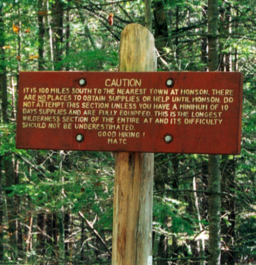
That's the region where you have the most uninhabited part of the Appalachian Trail, called the 100 Mile Wilderness. They've got a warning sign up there telling people to make sure they have at least 10 days worth of supplies before going in.
posted by damayanti at 8:06 AM on April 21, 2014 [14 favorites]
delfin: "I checked my map, and the only empty US space I saw was north of the Gorilla Communes and west of the Expanding Tiger Empire."
How did you call that one up? I keep hitting Command-D and nothing happens.
posted by Strange Interlude at 8:07 AM on April 21, 2014 [1 favorite]
How did you call that one up? I keep hitting Command-D and nothing happens.
posted by Strange Interlude at 8:07 AM on April 21, 2014 [1 favorite]
People live in Idaho? Wait, is Idaho real? Have I been lied to about Idaho?
To be precise, it's a collection of private Idahos.
And apparently I have my own, which I am living in. So I conclude that Idaho is really a vaguely determined unincorporated area in the DC metro region.
Much like Silver Spring, which is pretty much where you are if there's no other name for where you are around there.
posted by Naberius at 8:09 AM on April 21, 2014 [3 favorites]
Ambient Echo: I wonder how much of that land is Federal or state parks?
Dip Flash: In the west, a lot of it is federal. This map (pdf; from here) gives a sense of the scale of federal ownership in the west, especially the intermountain west.
Keen map, thanks! For others looking at that map, note that Bureau of Indian Affairs land are tribal nations, so they are indeed inhabited.
posted by filthy light thief at 8:10 AM on April 21, 2014
You can make out the outline of the Olympic National Park pretty well, but Big Bend NP must have some residents in the form of rangers, hotel & restaurant workers, etc. that live in the park, as only the eastern half of it is green. I'm guessing the big green blob in the middle of central Texas is Ft. Hood.
A lot of the other places are too dry or too steep to live.
posted by Devils Rancher at 8:13 AM on April 21, 2014
A lot of the other places are too dry or too steep to live.
posted by Devils Rancher at 8:13 AM on April 21, 2014
Related - Here is a map of distance to McDonalds.
posted by Pogo_Fuzzybutt at 8:13 AM on April 21, 2014 [4 favorites]
People live in Idaho? Wait, is Idaho real? Have I been lied to about Idaho?
They do but they prefer that everyone else thinks it's fictional so they don't move there and ruin it for them.
posted by Jess the Mess at 8:14 AM on April 21, 2014 [3 favorites]
They do but they prefer that everyone else thinks it's fictional so they don't move there and ruin it for them.
posted by Jess the Mess at 8:14 AM on April 21, 2014 [3 favorites]
This map explains why I want to move to the west coast some day. You can live in a city but still be very close to wilderness.
posted by scose at 8:17 AM on April 21, 2014 [1 favorite]
posted by scose at 8:17 AM on April 21, 2014 [1 favorite]
Wait, is Idaho real?
Where I come from we pronounce it "Iowa."
posted by Floydd at 8:17 AM on April 21, 2014 [1 favorite]
Where I come from we pronounce it "Iowa."
posted by Floydd at 8:17 AM on April 21, 2014 [1 favorite]
You can make out the outline of the Olympic National Park pretty well
I think a topographical map would show that elevation has a big influence as to where people live. Except for Alaska where remoteness still seems to exist on a large scale, but that's probably due to the weather.
posted by three blind mice at 8:19 AM on April 21, 2014
I think a topographical map would show that elevation has a big influence as to where people live. Except for Alaska where remoteness still seems to exist on a large scale, but that's probably due to the weather.
posted by three blind mice at 8:19 AM on April 21, 2014
As noted, it would be nice to have a more zoomable interactive version of this map.
Also, I'm wishing for answers to questions it brings up, like:
-- What is the most uninhabited state, in terms of the square miles of these zero-population census tracts?
-- What is the most inhabited state (the one with the lease area in zero-population tracts)?
-- Ditto for counties
-- How has this map changed over the last few censuses — are we getting more, or less inhabited? And which states are seeing the most change in inhabited area?
posted by beagle at 8:22 AM on April 21, 2014 [3 favorites]
Apologies for being thick, but I scanned TFA and couldn't find an answer: are these places places where literally no one lives, or places where population is at some negligible amount such that "practically" no one lives there?
It's worth remembering that this is Census data, which relies on people returning forms plus a certain amount of legwork. So these are the blocks with no recorded inhabitants -- you could still have transient inhabitants(this could include homeless people or recreational campers) or people who are not returning the forms (and, possibly, hiding from other forms of counting in a My Side of the Mountain scenario) so you can't be sure they are absolutely, constantly uninhabited, but there are so few people living in these areas that they are officially uninhabited.
posted by GenjiandProust at 8:24 AM on April 21, 2014 [1 favorite]
For others looking at that map, note that Bureau of Indian Affairs land are tribal nations, so they are indeed inhabited.
Within the areas marked as "Indian lands," you are going to find areas that are empty of people according to the census, even if those areas have part-time or seasonal use. That's true for a lot of the areas that show as depopulated -- there may be no permanent residents, but there may well be quite a few people there for significant parts of the year.
Or, on preview, pretty much what G&P just said.
posted by Dip Flash at 8:26 AM on April 21, 2014 [1 favorite]
List of U.S. states by population density. Interesting. I always thought Rhode Island was number 1, but New Jersey beat it out.
posted by Melismata at 8:27 AM on April 21, 2014
posted by Melismata at 8:27 AM on April 21, 2014
you could still have transient inhabitants(this could include homeless people or recreational campers) or people who are not returning the forms
The Census does have mechanisms to adjust for that. Before sending forms out they have people tabulating inhabited homes and doing spot checks. You still get counted if you don't return the form. So chances are that if they say there are no people, there really aren't any people. Campers get counted where they really live.
posted by beagle at 8:28 AM on April 21, 2014
Here's my effort to overlay state boundaries, if you get lost in space like I did. I tried to overlay the map of federal lands, but it got to be too visually noisy, and it's pretty easy to jump between images and get a good idea of which lands are unpopulated federal lands, and which are other lands. (Don't forget state lands, which are often the local equivalent of those federal classifications.)
Also, population density can be confusing in this discussion, as some states have dense urban cores and spare development elsewhere, while other states have decent distribution throughout and no real open land.
posted by filthy light thief at 8:29 AM on April 21, 2014 [3 favorites]
Also, population density can be confusing in this discussion, as some states have dense urban cores and spare development elsewhere, while other states have decent distribution throughout and no real open land.
posted by filthy light thief at 8:29 AM on April 21, 2014 [3 favorites]
People live in Idaho?
You can detect them because they say "Boise" with an unvoiced 's' sound instead of "Boize" the way normal human beings say it.
posted by straight at 8:32 AM on April 21, 2014
You can detect them because they say "Boise" with an unvoiced 's' sound instead of "Boize" the way normal human beings say it.
posted by straight at 8:32 AM on April 21, 2014
you could still have transient inhabitants [...]or people who are not returning the forms
Or they could recently been vaporized in artillery strikes...
posted by Tell Me No Lies at 8:36 AM on April 21, 2014 [2 favorites]
Or they could recently been vaporized in artillery strikes...
posted by Tell Me No Lies at 8:36 AM on April 21, 2014 [2 favorites]
I at first thought he had made Alaska larger than life for some reason--but nope! For anyone else as clueless as me, here is a nice scale comparison to make it clear: that place is enormous!
posted by TreeRooster at 8:38 AM on April 21, 2014 [2 favorites]
posted by TreeRooster at 8:38 AM on April 21, 2014 [2 favorites]
Also, population density can be confusing in this discussion, as some states have dense urban cores and spare development elsewhere, while other states have decent distribution throughout and no real open land.
Nevada stands out for that. There are eight states with lower average population densities, but Nevada is second only to Alaska in the percentage of public land (only about 12% of Nevada is private land).
posted by Dip Flash at 8:39 AM on April 21, 2014
Nevada stands out for that. There are eight states with lower average population densities, but Nevada is second only to Alaska in the percentage of public land (only about 12% of Nevada is private land).
posted by Dip Flash at 8:39 AM on April 21, 2014
It should also be mentioned that this isn't necessarily "empty" land, especially on the East Coast. Lots of those blocks have warehouses or office buildings or whatever, just no residences.
posted by tau_ceti at 8:39 AM on April 21, 2014 [6 favorites]
posted by tau_ceti at 8:39 AM on April 21, 2014 [6 favorites]
good point Tau Ceti! That's why we need this as an overlay to google maps
posted by rebent at 8:41 AM on April 21, 2014
posted by rebent at 8:41 AM on April 21, 2014
This is a neat project. I do wish that an interactive (or just a larger, more detailed) version of the map was available. I think the caveats are almost as interesting as the map itself.
As stated above, the census blocks are variable in size. I wish there was a larger map so that I could see how large the census blocks are around the Grand Canyon area. It looks like eastern Grand Canyon actually appears as an inhabited area. This may be due to a handful of permanent residents who live in a few inner-canyon buildings. I suspect that these few residents are causing a huge, empty area to show up as a large, inhabited tract of land.
I can see one white pixel that may or may not represent Supai, a village on the Havasupai Reservation. It is located in a side canyon in the western Grand Canyon area, eight miles from the nearest road. US Mail arrives and departs on the backs of mules.
Someone above joked about Cliven Bundy. There is a ghost town named Bundyville in the isolated Arizona Strip (a strip of Arizona land separated from the rest of the state by Grand Canyon). As of 2006, Bundyville had one surviving resident. Based on what I've read, I suspect that the namesake family are ancestors of Cliven Bundy. So whether or not that portion of the Arizona Strip is populated may depend on whether a distant relative of Cliven Bundy is still alive. There are two white pixels in the general area of Bundyville, so perhaps the resident was still alive as of 2010?
(Thank you, filthy light thief, for the overlays! They help a little, but I could still be totally wrong about what exists where.)
The mapmaker also says that developed industrial and commercial areas can appear as uninhabited blocks, because they have no permanent residents. This is an interesting note, because I suspect that many developed-but-officially-uninhabited industrial/commercial blocks are in fact likely to be inhabited. Homeless residents, though, may not appear in census data for those areas.
If some industrious person is interested in putting together a high-res version of this map, the mapmaker cites his data sources at the bottom of the page. The map was created with an open-source program called Tilemill, which I had not previously heard of but which sounds really neat and I wish I had time to play around with it.
posted by compartment at 8:46 AM on April 21, 2014 [2 favorites]
The only map you really need.
That is literally the the most inaccurate map I have ever seen.
posted by cosmic.osmo at 8:46 AM on April 21, 2014 [10 favorites]
That is literally the the most inaccurate map I have ever seen.
posted by cosmic.osmo at 8:46 AM on April 21, 2014 [10 favorites]
I can't find a good map of it online but from my memory of playing with GIS years ago I think that the perception here is a little skewed because the census blocks themselves are bigger out west. Yes there are places out west where no one "lives" but there are certainly desert/mountain dwellers you run across out there and they may not have been captured by the census.
three blind mice: "I think a topographical map would show that elevation has a big influence as to where people live. Except for Alaska where remoteness still seems to exist on a large scale, but that's probably due to the weather."
I think it's mostly weather everywhere. Less water = less conducive to survival. The uninhabitable elevation extremes are much rarer out west that just generally so dry.
posted by Big_B at 8:49 AM on April 21, 2014
Its a great perspective changing project.
I wonder if saying "47% uninhabited" is a little misleading, though. It's 47% of the census blocks, and that 47% result could be adjusted up or down arbitrarily to any percentage at all by adjusting the size of those blocks. If there were only one census block, this approach would conclude the US was 0% uninhabited. If the blocks were one square meter each, this approach would conclude the US was virtually uninhabited.
posted by Western Infidels at 8:54 AM on April 21, 2014 [1 favorite]
Less water = less conducive to survival.
Well, the other end of the spectrum is true too. A lot of the uninhabited parts of the southeast are swamp. They're probably inhabitable, in the sense that they could be drained and built on if we really wanted to, but it's good that we don't.
posted by Kadin2048 at 8:54 AM on April 21, 2014 [2 favorites]
This just reminds me how different portions of the "Midwest" are from each other. The line started by the western edge of Minnesota and Iowa all the way down to the gulf really is much more like the Eastern US in many, many ways than everything to the west of about the Missouri river.
posted by Muddler at 8:55 AM on April 21, 2014
posted by Muddler at 8:55 AM on April 21, 2014
man, it's almost like we need a GIS layer in google maps where 1 dot = 1 person
posted by rebent at 9:00 AM on April 21, 2014
posted by rebent at 9:00 AM on April 21, 2014
The USA ranks 179th for population density, having one-eighth that of the UK
...
List of U.S. states by population density.
It's interesting to put those together. The US overall isn't very densely populated, but that's because Alaska has very low density and the western US is sparsely populated until you hit the coastal states.
New Jersey is basically as dense as South Korea, for example. Florida and New York are approximately as dense as Wales. North Carolina is about as dense as Egypt, Ukraine, or Burma.
What would be really interesting would be the median population density of the square kilometer or mile surrounding each person -- what is the population density the average resident finds themselves in?
posted by ROU_Xenophobe at 9:00 AM on April 21, 2014
It looks like eastern Grand Canyon actually appears as an inhabited area
The eastern end of the Grand Canyon butts up against the Navajo nation (it pretty much ends at the Canyon rim) and there are a bunch of dwellings back in there. It's surprisingly populated, given how desolate the surrounding area (especially southern Utah) is.
posted by Pogo_Fuzzybutt at 9:02 AM on April 21, 2014 [1 favorite]
Florida and New York are approximately as dense as Wales.
And again, the numbers are skewed by dense cities in their midst. Upstate New York has some beautiful empty parts.
posted by Melismata at 9:02 AM on April 21, 2014
And again, the numbers are skewed by dense cities in their midst. Upstate New York has some beautiful empty parts.
posted by Melismata at 9:02 AM on April 21, 2014
If there were only one census block, this approach would conclude the US was 0% uninhabited.
Wouldn't it conclude 100 percent inhabited?
posted by wikipedia brown boy detective at 9:04 AM on April 21, 2014 [1 favorite]
Wouldn't it conclude 100 percent inhabited?
posted by wikipedia brown boy detective at 9:04 AM on April 21, 2014 [1 favorite]
man, it's almost like we need a GIS layer in google maps where 1 dot = 1 person
Someone made this a while ago, not a google maps overlay however.
posted by wikipedia brown boy detective at 9:06 AM on April 21, 2014
Someone made this a while ago, not a google maps overlay however.
posted by wikipedia brown boy detective at 9:06 AM on April 21, 2014
OK Here we go: 1 dot per person, somehow via census blocks. Ignore the colors which show racial segregation for now. I think this map was posted here previously.
I'm looking for Bundyville right now
posted by rebent at 9:06 AM on April 21, 2014 [2 favorites]
I'm looking for Bundyville right now
posted by rebent at 9:06 AM on April 21, 2014 [2 favorites]
The unpopulated areas of North Carolina are hideous swamplands.
That's what the big area in south GA/north FL is too - Okefenokee Swamp and its wildlife refuge.
posted by bizzyb at 9:09 AM on April 21, 2014
That's what the big area in south GA/north FL is too - Okefenokee Swamp and its wildlife refuge.
posted by bizzyb at 9:09 AM on April 21, 2014
Nobody lives there anymore. It's too crowded.
posted by bowmaniac at 9:10 AM on April 21, 2014 [2 favorites]
posted by bowmaniac at 9:10 AM on April 21, 2014 [2 favorites]
Also note: there is a difference between 'no on lives' and 'no one goes to'. There are huge tracts of wilderness that get packed full of people every summer camping under every tree where their actual physical address is in a city someplace else. Also, big farms or ranches have workers but they don't call that their mailing address.
posted by BearClaw6 at 9:23 AM on April 21, 2014
posted by BearClaw6 at 9:23 AM on April 21, 2014
The only map you really need.
That is literally the the most inaccurate map I have ever seen.
Only because you're misreading the labels. "You" there refers to the inhabitants of the star system in the Andromeda Galaxy (indicated by the arrow) that the Arecibo radio telescope sent this picture to. We thought it might help them get their bearings in case they got turned around a bit, what with M31 spinning all the time.
posted by straight at 9:26 AM on April 21, 2014 [2 favorites]
Yeah if you haven't driven across it, it can be kind of hard to grok just how much of the country is nothing at all. There are parts of Kansas I drove through that are just cornfields and enormous windmills and creepy old timey preachers on the three radio stations you can get. I remember stopping for gas somewhere in Wyoming where the gas station was also the City Hall, post office, a hotel, and the grocery store for the nearby trailer park. There's good-sized chunks of the country where it's a good idea to stop at any gas station you see for gas/bathroom breaks because the next one might be a couple hundred miles down the road.
posted by Ghostride The Whip at 9:32 AM on April 21, 2014 [3 favorites]
posted by Ghostride The Whip at 9:32 AM on April 21, 2014 [3 favorites]
Interesting that the only internal state borders that are clearly delineated are the ones defining North Dakota. (And possibly the NM/CO and OK/KS borders).
posted by univac at 9:42 AM on April 21, 2014
posted by univac at 9:42 AM on April 21, 2014
There's good-sized chunks of the country where it's a good idea to stop at any gas station you see for gas/bathroom breaks because the next one might be a couple hundred miles down the road.
At the risk of excessive pedantry, my recollection is that the longest gap between gas stations in the lower 48 is about 70 or 80 miles. Which of course feels like 200 if your gas gauge is getting low.
posted by Dip Flash at 9:44 AM on April 21, 2014
At the risk of excessive pedantry, my recollection is that the longest gap between gas stations in the lower 48 is about 70 or 80 miles. Which of course feels like 200 if your gas gauge is getting low.
posted by Dip Flash at 9:44 AM on April 21, 2014
Upon googling, it looks like it is 105 miles with no services on I70, and some longer stretches on secondary roads here and there, especially Nevada. I stand corrected.
posted by Dip Flash at 9:48 AM on April 21, 2014 [2 favorites]
posted by Dip Flash at 9:48 AM on April 21, 2014 [2 favorites]
-- What is the most uninhabited state, in terms of the square miles of these zero-population census tracts?
Alaska
-- What is the most inhabited state (the one with the lease area in zero-population tracts)?
New Jersey
-- Ditto for counties
You're on your own.
posted by Herodios at 9:52 AM on April 21, 2014
Alaska
-- What is the most inhabited state (the one with the lease area in zero-population tracts)?
New Jersey
-- Ditto for counties
You're on your own.
posted by Herodios at 9:52 AM on April 21, 2014
-- What is the most inhabited state (the one with the lease area in zero-population tracts)?
New Jersey
Or District of Columbia, by far, if counted as a state.
posted by Herodios at 9:55 AM on April 21, 2014 [1 favorite]
New Jersey
Or District of Columbia, by far, if counted as a state.
posted by Herodios at 9:55 AM on April 21, 2014 [1 favorite]
I thought it was interesting to see a big round blob on the South Carolina side of the Savannah River, about halfway to the coast. I checked and sure enough it's the Savannah River Site, as seen on this map.
posted by TedW at 10:03 AM on April 21, 2014
posted by TedW at 10:03 AM on April 21, 2014
Yeah, looking at the Lake of the Woods bit of northern Coldisota or Cheesconsin or whatever that state is sort of makes you wonder why we wanted that bit that pokes into Canada if we're not going to use it or anything. But the population heat map doesn't make it clear that it's mostly lake.
posted by George_Spiggott at 10:14 AM on April 21, 2014 [2 favorites]
posted by George_Spiggott at 10:14 AM on April 21, 2014 [2 favorites]
Years ago, shortly after 9/11, a friend of mine was teaching in Montana and she had her students writing letters. Since I was living in NYC a few of her kids sent me letters about what had happened. I remember thinking how strange it was that there were more people in my apt building then there were in this entire small town in Montana.
posted by R. Mutt at 10:23 AM on April 21, 2014
posted by R. Mutt at 10:23 AM on April 21, 2014
And again, the numbers are skewed by dense cities in their midst. Upstate New York has some beautiful empty parts.
Well, I mean, the exact same is true of Wales.
posted by erlking at 10:31 AM on April 21, 2014 [2 favorites]
Well, I mean, the exact same is true of Wales.
posted by erlking at 10:31 AM on April 21, 2014 [2 favorites]
Interesting maps here at the National Center for Frontier Communities map page.
The most interesting line on the Nobody Lives Here map to me is the north New York Vermont border. There isn't any obvious reason why people seem to so strongly prefer to live on the Vermont side.
posted by bukvich at 10:33 AM on April 21, 2014
The most interesting line on the Nobody Lives Here map to me is the north New York Vermont border. There isn't any obvious reason why people seem to so strongly prefer to live on the Vermont side.
posted by bukvich at 10:33 AM on April 21, 2014
The creator linked to a zoomable version on reddit: http://mapsbynik.com/maps/census0pop/
posted by fitnr at 10:35 AM on April 21, 2014 [3 favorites]
posted by fitnr at 10:35 AM on April 21, 2014 [3 favorites]
New Jersey is basically as dense as South Korea, for example
The crazy thing is there's still a fairly large patch with no people- mainly, the Pine Barrens. cf. Rhode Island and Connecticut, for example, which don't have any large green patches.
So the dense areas of New Jersey are dense.
posted by damayanti at 10:38 AM on April 21, 2014
The crazy thing is there's still a fairly large patch with no people- mainly, the Pine Barrens. cf. Rhode Island and Connecticut, for example, which don't have any large green patches.
So the dense areas of New Jersey are dense.
posted by damayanti at 10:38 AM on April 21, 2014
The fact that it uses Census blocks which are really variable in size, along with "any population," makes it kind of vaguely confusing; the areas of Alaska that aren't green could either represent one homestead parked in the middle of nowhere or a huge sprawling semi-urban area (which is a thing that does exist there).This map quietly infuriates me. I used to live on Nunivak Island AK which has two census tracts. One is the village of Mekoryuk, the only “permanent” village on the island. This shows up as a tiny white dot on the northeast coast if you zoom in. The rest of the island is green on this map. With only 200 year-round inhabitants and a size about like Rhode Island, Nunivak is indeed very sparsely populated.
But it’s hardly “uninhabited.” There are fish camps along the rivers and coasts which are inhabited in the summer. Also year-round hunting camps, reindeer or muskox herding stations, research stations, and other semi-permanent abodes elsewhere on the island. These are all settlements with buildings and some infrastructure. You are seldom more than a dozen miles away from another human being on Nunivak. But they are people whose way of life is not well represented or understood by tools like the census. I think much of the Alaskan bush is like this.
I could relate similar stories about similarly “uninhabited” pieces of Wyoming, North Dakota, and western Montana (all are places I used to live).
posted by axoplasm at 10:45 AM on April 21, 2014 [3 favorites]
So do we call them 'green states' now instead of 'red states'?
posted by MtDewd at 10:50 AM on April 21, 2014
posted by MtDewd at 10:50 AM on April 21, 2014
rebent: "OK Here we go: 1 dot per person, somehow via census blocks. Ignore the colors which show racial segregation for now. I think this map was posted here previously."
Click on the Remove Color-Coding button on the left side.
posted by Big_B at 10:53 AM on April 21, 2014 [3 favorites]
Click on the Remove Color-Coding button on the left side.
posted by Big_B at 10:53 AM on April 21, 2014 [3 favorites]
I work at a NASA-funded university data center that distributes similar data in gridded form (rather than by admin boundary). If anyone wants to play around with it the gridded data are in ascii and geotiff format for 1990 and 2000. The grids are at 30 arc-second resolution (~1 km at equator) and the Summary File 1 and SF 3 data include pop count, demographic info and housing info.
posted by plastic_animals at 10:54 AM on April 21, 2014 [4 favorites]
posted by plastic_animals at 10:54 AM on April 21, 2014 [4 favorites]
Ghostride The Whip: Yeah if you haven't driven across it, it can be kind of hard to grok just how much of the country is nothing at all.
From the other side of the country, I find it freaky how much of the country (particularly in the East) is just continuous, uninterrupted town. Truthfully, I have no idea how you stand living in a place like that.
posted by Mitrovarr at 11:00 AM on April 21, 2014 [7 favorites]
From the other side of the country, I find it freaky how much of the country (particularly in the East) is just continuous, uninterrupted town. Truthfully, I have no idea how you stand living in a place like that.
posted by Mitrovarr at 11:00 AM on April 21, 2014 [7 favorites]
The creator linked to a zoomable version on reddit
Nice, this is pretty much what I was looking for. Marble Canyon (the north/easternmost portion of Grand Canyon, which runs roughly from Glen Canyon Dam to the Little Colorado confluence) is shown as uninhabited. Navajo lands to the east of Marble Canyon are a patchwork of inhabited and uninhabited parcels, which makes me doubt the accuracy of census data in this area. As Pogo_Fuzzybutt says, there are a lot of dwellings in that area.
The inner Grand Canyon east of Great Thumb Mesa (i.e., the area encompassing what you will probably see if you drive to a scenic overlook) is, according to the big map, inhabited. That is a huge amount of empty land that appears to be inhabited on the basis of a very small number of permanent residents.
I don't think the big map shows every single census block, or when blocks were first established, but some of the boundaries seems to be mark settlements that no longer exist.
posted by compartment at 11:11 AM on April 21, 2014
I'd like a comparison -- at least for the homestead-patent areas in the upper Midwest -- to census data from 1920. For instance, North Dakota today has about the same population as it had in the 1920s...but back then, there was a farmstead about every half-mile or so and the "big cities" were only about 20,000 people. Today, as you can see on the map, very few people live out in those areas, our current population is mostly urban, so I wonder how less "green" North Dakota was a hundred years ago.
posted by AzraelBrown at 11:14 AM on April 21, 2014
posted by AzraelBrown at 11:14 AM on April 21, 2014
I'm beginning to think vast swaths of uninhabited land are slightly overrepresented in the Senate.
posted by Bromius at 11:25 AM on April 21, 2014 [4 favorites]
posted by Bromius at 11:25 AM on April 21, 2014 [4 favorites]
Living in Orlando, I found it interesting that some of the largest green zones still have tons of people, just no permanent residents. Disneyworld and the I-drive/Universal tourist corridor show up as big(ish) green areas even though there are tens of thousands of people there at any given time. Then there are the urban areas that are just industrial and commercial districts, so they may be unpopulated, but still have people present at most times.
posted by Badgermann at 12:02 PM on April 21, 2014 [1 favorite]
posted by Badgermann at 12:02 PM on April 21, 2014 [1 favorite]
"vast swaths of uninhabited land..."
“As you all surely know, the Senate is not a terribly democratic institution. A voter in Wyoming — population 533,000 — has about 70 times more ability to influence the Senate’s direction than one in California — population 36.8 million.” [Nate Silver]
posted by LeLiLo at 12:10 PM on April 21, 2014
“As you all surely know, the Senate is not a terribly democratic institution. A voter in Wyoming — population 533,000 — has about 70 times more ability to influence the Senate’s direction than one in California — population 36.8 million.” [Nate Silver]
posted by LeLiLo at 12:10 PM on April 21, 2014
I'm beginning to think vast swaths of uninhabited land are slightly overrepresented in the Senate.
Only if you manage to forget or misunderstand why the Senate is composed like it is.
posted by donnagirl at 12:12 PM on April 21, 2014 [2 favorites]
Only if you manage to forget or misunderstand why the Senate is composed like it is.
posted by donnagirl at 12:12 PM on April 21, 2014 [2 favorites]
beagle: "-- What is the most uninhabited state, in terms of the square miles of these zero-population census tracts?"
Alaska by a country mile. By an Alaskan mile, even.
"Ditto for counties"
Wikipedia has your back. Densest counties are Manhattan, Brooklyn (King's Co), Bronx, Queens, and San Francisco. Least dense are Yukon-Koyukuk, Lake & Peninsula, Yakutat, and North Slope (all in Alaska), and then Loving County Texas. Yukon-Koyukuk has a population density of .03 people per square mile; Loving County has .12 people per square mile. Manhattan has 69,468 per square mile; Brooklyn is 35,369. Washington DC is 9,857 per square mile (it's not very tall there). Cook County, which includes Chicago and a bunch of suburbs (and supposedly is the urban county with the greatest greenspace in the US, due to the forest preserve), is 5,495 people per square mile.
posted by Eyebrows McGee at 12:33 PM on April 21, 2014 [2 favorites]
vast swaths of uninhabited land are slightly overrepresented in the Senate.
Man, you just gave me a brief vision of a world in which there would be a Senator Puma Concolor (D-Mojave). Imagine the committee meetings! Dang it, I wish I lived in that world.
Yes, I am imagining that the mountain lion is a democrat. Because come on, of course she is!
posted by hap_hazard at 12:34 PM on April 21, 2014
In the U.S., checking Google Maps for Street View coverage is a good way of illustrating where nobody lives.
Northern Maine really pops out in that map. It's so strikingly unpopulated that you can discern the US/Canada border even with labels turned off.
I live in a Western Maine, separated from Canada by forest, and it's easy to forget how close we are to that "foreign" culture. We have folks from Québec pass through town, but they have to get here through New Hampshire or a neighboring county, as there is no direct route. The border is only a couple hours' drive away, but it took the recent tragedy in Lac-Mégantic to bring home how close we are.
posted by Knappster at 12:57 PM on April 21, 2014
Northern Maine really pops out in that map. It's so strikingly unpopulated that you can discern the US/Canada border even with labels turned off.
Actually, keep it quiet but we up here are mostly not here. The country is pretty much just me and gman and Alvy Ampersand turning on the water now and again in the winter so the pipes don't freeze.
posted by ricochet biscuit at 1:17 PM on April 21, 2014 [3 favorites]
Actually, keep it quiet but we up here are mostly not here. The country is pretty much just me and gman and Alvy Ampersand turning on the water now and again in the winter so the pipes don't freeze.
posted by ricochet biscuit at 1:17 PM on April 21, 2014 [3 favorites]
If nobody lives there, then why all this complaining about clear cutting this area? Nobody has to live there? I mean... I think I see a way to repurpose these national parks. Also, it is possible to free up some of this land by combining military practice ranges and national parks as well. Think about the money the government could put towards the national debt if we fully utilized the parts we want to and then leveraged the free market to maximize the sale of the rest! We may even be able to lower our taxes in the process.
Oh woah... I just realized I accidentally picked up Paul Ryan's koolaid cup at the last mixer we attended together... My bad. Forget what I just said.
posted by Nanukthedog at 1:18 PM on April 21, 2014 [1 favorite]
Oh woah... I just realized I accidentally picked up Paul Ryan's koolaid cup at the last mixer we attended together... My bad. Forget what I just said.
posted by Nanukthedog at 1:18 PM on April 21, 2014 [1 favorite]
Argh. You know how, when the weather gets cold, the climate-change deniers all say "See? Global warming is a hoax!."
I'm kinda sad to see this map because--interesting as it is--it's the population analog of a cold snap. That is, it'll be an occasion for confused but passionate overpopulation deniers to say "See? No problem!"
posted by Fists O'Fury at 1:48 PM on April 21, 2014
I'm kinda sad to see this map because--interesting as it is--it's the population analog of a cold snap. That is, it'll be an occasion for confused but passionate overpopulation deniers to say "See? No problem!"
posted by Fists O'Fury at 1:48 PM on April 21, 2014
yes the science on "overpopulation' is clearly as settled as climate change?
posted by JPD at 2:00 PM on April 21, 2014 [1 favorite]
posted by JPD at 2:00 PM on April 21, 2014 [1 favorite]
The crazy thing is there's still a fairly large patch with no people- mainly, the Pine Barrens.
For which read John McPhee's The Pine Barrens. Dated, but v. interesting. (Interesting people have lived in the Pinelands.)
posted by BWA at 2:17 PM on April 21, 2014 [2 favorites]
For which read John McPhee's The Pine Barrens. Dated, but v. interesting. (Interesting people have lived in the Pinelands.)
posted by BWA at 2:17 PM on April 21, 2014 [2 favorites]
Yes, I am imagining that the mountain lion is a democrat. Because come on, of course she is!
Do you have any cats? Mine are totally Republicans. They love handouts, but then they make somebody else clean up their shit.
posted by Kadin2048 at 2:52 PM on April 21, 2014 [9 favorites]
Do you have any cats? Mine are totally Republicans. They love handouts, but then they make somebody else clean up their shit.
posted by Kadin2048 at 2:52 PM on April 21, 2014 [9 favorites]
damayanti, I think it's actually 12 days of food.. though I've done that portion in 6 days before (100-mile wilderness + 20miles = 120 total).
posted by mbatch at 4:03 PM on April 21, 2014
posted by mbatch at 4:03 PM on April 21, 2014
I love going into Google Street View and plopping the man down in the middle of nowhere in nothern Nevada or elsewhere in the giant empty expanse out West. I grew up in southern New Mexico, so I'm used to stretches of empty road, but the most utterly empty stretch I've ever driven on has to be Route 491 (formerly 666) between Gallup and Shiprock.
posted by pravit at 5:09 PM on April 21, 2014
posted by pravit at 5:09 PM on April 21, 2014
Wow, that map really starkly shows where western expansion ended. East of the Mississippi it's visible. You can plainly see, as has been said above, a town every x number of miles.
West of that, and all bets are off. And I'm guessing that you can see the Dakotas because they missed that first wave, where all the small towns are now. I'm pretty sure it has to do with one of the early reservations essentially being "The Dakota Territory".
I was surprised so much of Hawaii was uninhabited, then I remembered that huge fuck-off cattle herd that's been there for 150 odd years. One of the largest cattle herds in America IIRC.
Anecdotally, I just returned from a drive to way northern Minnesota and there are dozens of these tiny, tiny towns evenly spaced over the landscape, and you'll see train lines to them, ostensibly to return grain to the Cities where we'd mill it, and barge it down the river to New Orleans, or later on railroad it up to Duluth, and ship it all over the world.
Then you drive for 20-30 miles and don't see more than ten or fifteen cars, it's that barren.
posted by Sphinx at 5:16 PM on April 21, 2014
Do you have any cats?
Well I have and I'm afraid they mostly leaned libertarian as far as I can tell, but on the other hand if you thought they'd put up with any logging, mining, cattle grazing or golf-course-building in their habitat you would have been sorely mistaken! So I can't see them voting R.
posted by hap_hazard at 5:37 PM on April 21, 2014
If you look very closely, there are census blocks in NYC that are uninhabited. New York, being the most densely populated large city (this is excluding several incorporated areas of approximately 50,000 in New Jersey, right across the Hudson) in the United States still has areas where no one lives. They are places like the old navy yard, or certain industrial areas, but not having people living in a census block is not as uncommon as people think.
It's easiest to see if you zoom in using cosmic.osmo's map.
(Central Park is technically uninhabited, but I think that's a lie.)
Also, that "You are here map" with Andromeda really should be a "You will be here," or perhaps "The earth will be here," or morbidly "The atoms that make up your body and will be long dispersed into the soil or blown out into space by the expanding sun will be here or somewhere nearby." But that's a mouthful.
posted by Hactar at 7:35 AM on April 22, 2014
If nobody lives there, then why all this complaining about clear cutting this area? Nobody has to live there? I mean... I think I see a way to repurpose these national parks. Also, it is possible to free up some of this land by combining military practice ranges and national parks as well.
posted by Nanukthedog
Bad dog! Bad dog!
posted by wenestvedt at 9:20 AM on April 22, 2014 [2 favorites]
posted by Nanukthedog
Bad dog! Bad dog!
posted by wenestvedt at 9:20 AM on April 22, 2014 [2 favorites]
I think I can make out I90 in South Dakota, but what's the clear line of inhabited territory about halfway further up the state? Old train line, maybe?
posted by rmd1023 at 9:45 AM on April 22, 2014
posted by rmd1023 at 9:45 AM on April 22, 2014
« Older Beats Unraveled | Saving The Bay Newer »
This thread has been archived and is closed to new comments
posted by rebent at 7:16 AM on April 21, 2014 [1 favorite]