A Guide To Rivers, Plains, Planets, Stars
December 22, 2009 9:26 AM Subscribe
Peacay of BibliOdyessey highlights some stunning examples of Victorian Infographics from the Rumsey Map Collection(previously). (Direct Flickr link)
Sys Rq:
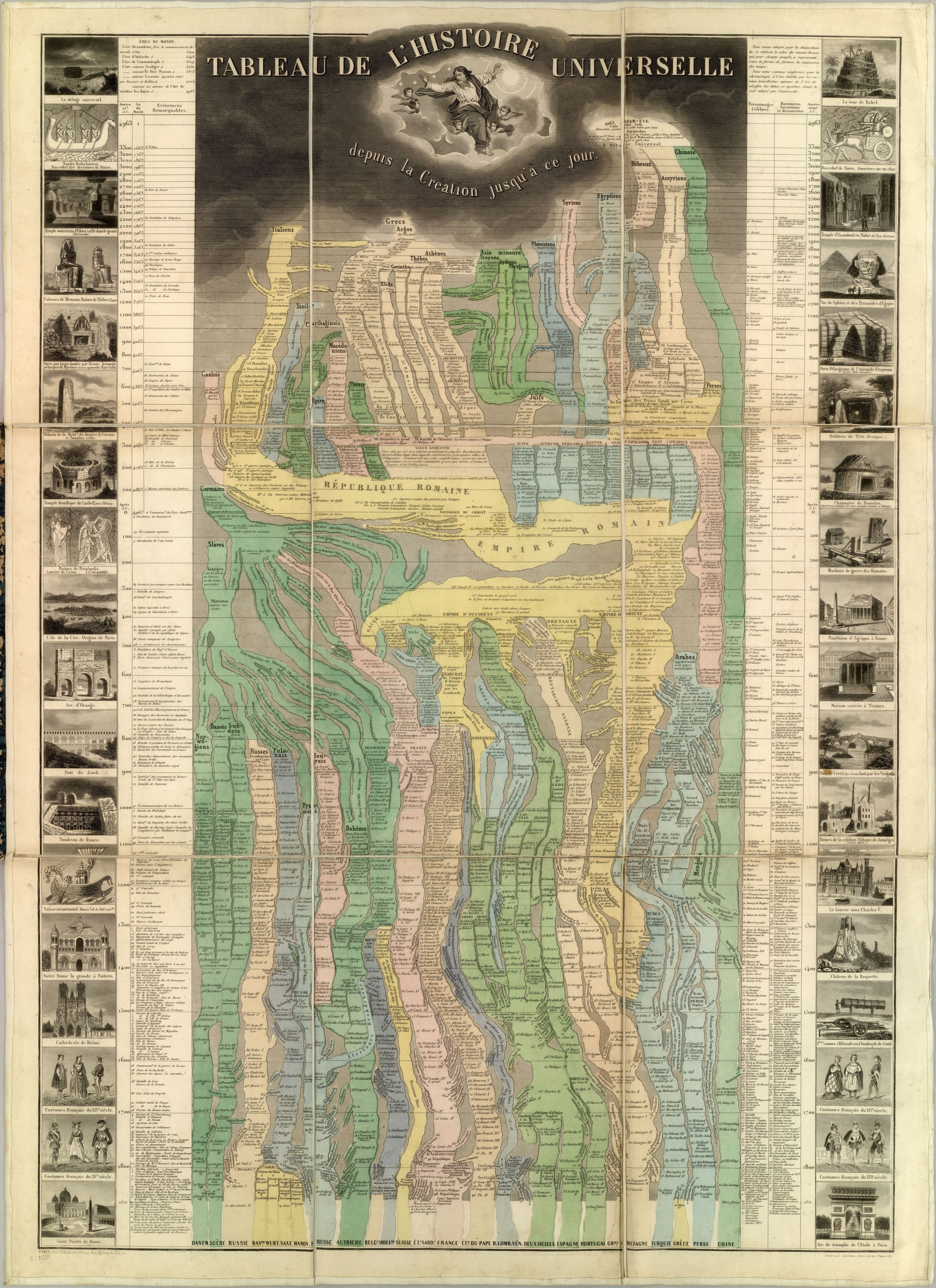
It's a history of the world, starting with Adam And Eve and then following their linage to the nation-states.
posted by The Whelk at 9:45 AM on December 22, 2009
It's a history of the world, starting with Adam And Eve and then following their linage to the nation-states.
posted by The Whelk at 9:45 AM on December 22, 2009
Also: Charles Minard's famous graphic mapping of Napolean's campaign in Russia (this was the best resolution I could find with an admittedly quick search).
posted by jokeefe at 9:48 AM on December 22, 2009
posted by jokeefe at 9:48 AM on December 22, 2009
(Actually, you can enlarge it, so it's totally readable. It's an amazing piece of work.)
posted by jokeefe at 9:50 AM on December 22, 2009
posted by jokeefe at 9:50 AM on December 22, 2009
Is there someplace online that sells originals or reprints of material similar to this?
posted by billysumday at 9:59 AM on December 22, 2009
posted by billysumday at 9:59 AM on December 22, 2009
Sys Rq - my French is a little rusty, but I read it as a chart of the political organization of the world's peoples, from the day of Creation (in 4963 BC) down to the present day (in 1858). The vertical "swim-lanes" seem to represent geographical locations - you can see at bottom they're labeled with political divisions as they existed in the mid-1850s (i.e., there are separate entries for the Kingdom of the Two Sicilies and the Papal States and various other Italian polities, rather than one for Italy).
The branches and flows in the chart seem to represent different races and countries as they conquer different places, and look to be inscribed with the names of empires and prominent rulers. Running down the y-axis to the left side of the chart is a list of important events, and on the right side a list of famous people and important inventions. The chart appears to treat the Old Testament as a perfectly reliable historical source and indeed also lists Greek mythological figures such as Atlas, Achilles and Orpheus in the Famous People column.
posted by strangely stunted trees at 10:02 AM on December 22, 2009
Yeah, no shit. I said EXPANSION, not explanation.
to read makes the writing english good.
posted by The Whelk at 10:18 AM on December 22, 2009
And here's a more contemporary piece: Harold N. Fisk's Geological Investigation of the Alluvial Valley of the Lower Mississippi River (via Pruned). (Full Resolution pdfs are located in the Fisk 44 Oversized Plates link (Plates 22-1 through 22-15 being the most famous and beautiful)
Truly, the most beautiful piece of infographic goodness the US Government has ever produced.
posted by Chrischris at 10:27 AM on December 22, 2009 [1 favorite]
Truly, the most beautiful piece of infographic goodness the US Government has ever produced.
posted by Chrischris at 10:27 AM on December 22, 2009 [1 favorite]
Compile runcible.
posted by Babblesort at 10:42 AM on December 22, 2009 [2 favorites]
posted by Babblesort at 10:42 AM on December 22, 2009 [2 favorites]
Shit. I'm lost in the Tableau de L'Histoire Universelle, and my boss is not going to be happy with my productivity today. Expand it here.
posted by kanewai at 11:38 AM on December 22, 2009
posted by kanewai at 11:38 AM on December 22, 2009
This one could do with some expansion. Any takers?
Done!
posted by DU at 11:52 AM on December 22, 2009 [1 favorite]
Done!
posted by DU at 11:52 AM on December 22, 2009 [1 favorite]
A salute to David Rumsey. An awesome guy.
"I realized that whichever institution I gave it to would lock it away, put it on a shelf," he says, with mild indignation. "But just then the technology came along that would enable me to put it all up online, and it was obvious that this was the best way I could give it away to the public."
SFGate Article...
posted by thisisdrew at 7:07 PM on December 22, 2009
If I recall correctly, ConEd still uses versions of those topographical maps of manhattan for something. Maybe some of the sewers empty out into old stream beds? Is this ringing any bells?
posted by shothotbot at 7:48 PM on December 22, 2009
posted by shothotbot at 7:48 PM on December 22, 2009
These are fantastic.
Noticed the Cy. abbreviation for "city" on the time table piece; haven't seen that before. I love old abbreviation marks like that. Why have they gone out of use?
(Suppose it's to do with the advent of computers and limited symbol sets...)
posted by spitefulcrow at 8:08 PM on December 24, 2009
Noticed the Cy. abbreviation for "city" on the time table piece; haven't seen that before. I love old abbreviation marks like that. Why have they gone out of use?
(Suppose it's to do with the advent of computers and limited symbol sets...)
posted by spitefulcrow at 8:08 PM on December 24, 2009
« Older The Silver Thief | Savant who inspired Rain Man dies Newer »
This thread has been archived and is closed to new comments
posted by mathowie at 9:30 AM on December 22, 2009