Africa: History, Cartography and Exploration
July 7, 2011 9:00 AM Subscribe
Evolution of the Map of Africa
Further reading:
The Republic of South Africa's Parliamentary Millennium Programme has a Virtual Tour (flash required), which contrasts foreign and domestic perspectives of Africa. The exhibition originally was shown in Capetown and included the oldest known map of the African continent, dating back to 1389.
Additional historic maps of Africa are available online:
* David Rumsey Map Collection Database and Blog: Africa. The full collection now has 27,000 historical maps and images online. Previously: 1, 2, 3)
* Northwestern University Library: 16th to 20th Century Maps of Africa (Previously on MeFi)
* Royal Museum for Central Africa: The Online Collection of Ancient Maps: Introduction. Collection.
* American Museum of Natural History: 1562 - 1940
* Yale University Library: The Map Collection: Maps of Africa. The Collection has additional maps available.
* University of Illinois at Urbana-Champaign: Maps of Africa to 1900 (767 items)
* The University of Texas at Austin: Perry-Castañeda Library Map Collection: Historical Maps of Africa
* Michigan State University: Scanned maps of Africa
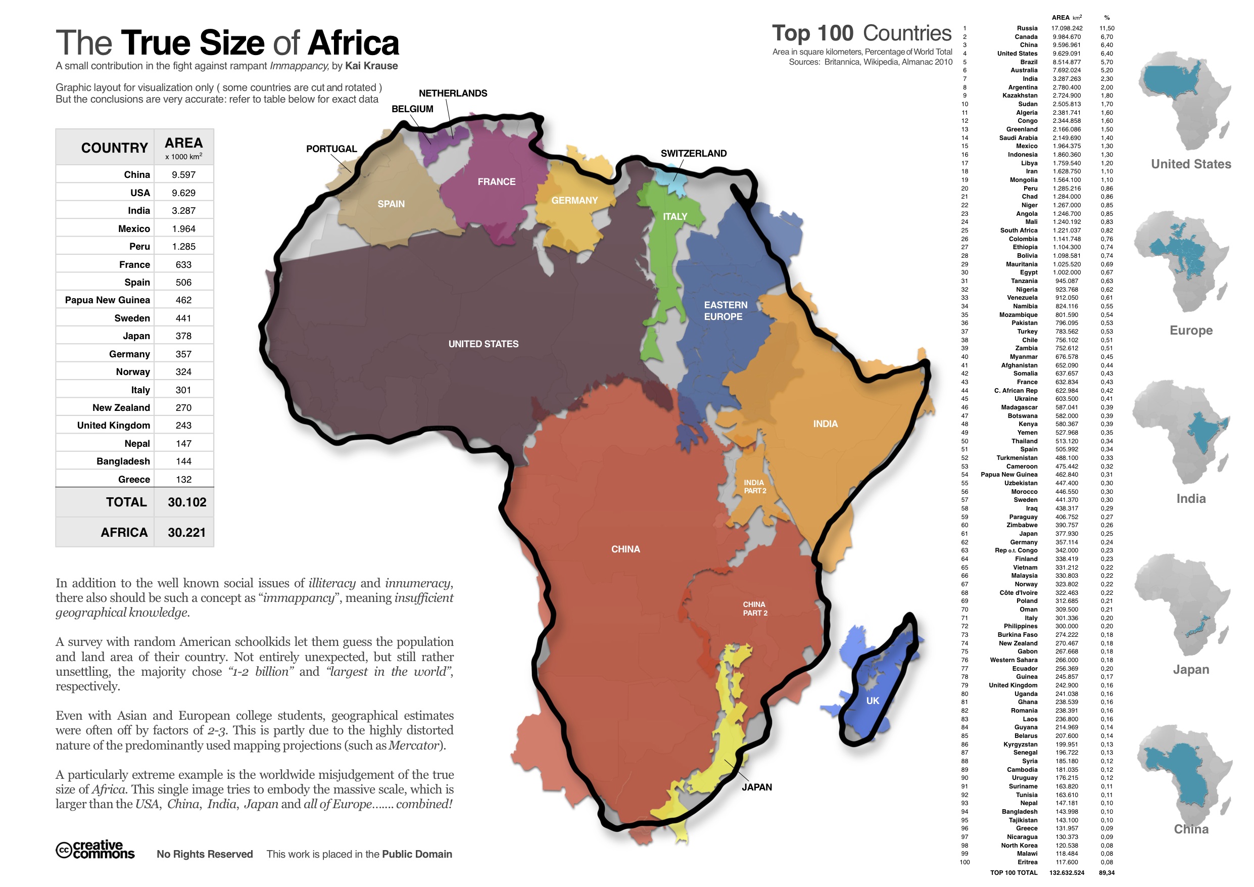
See also this map of the size of Africa, which shocks most people when they first see it. (Spoiler: Africa is HUGE.)
posted by desjardins at 9:08 AM on July 7, 2011 [1 favorite]
posted by desjardins at 9:08 AM on July 7, 2011 [1 favorite]
desjardins: "See also this map of the size of Africa, which shocks most people when they first see it. (Spoiler: Africa is HUGE.)"
Definitely shocked the hell out of me. Previously! :)
posted by zarq at 9:21 AM on July 7, 2011
Definitely shocked the hell out of me. Previously! :)
posted by zarq at 9:21 AM on July 7, 2011
"[Africa] is big. You just won't believe how vastly, hugely, mind- bogglingly big it is. I mean, you may think it's a long way down the road to the chemist's, but that's just peanuts to [Africa]." (with apologies to D.A)
posted by blue_beetle at 9:21 AM on July 7, 2011 [2 favorites]
posted by blue_beetle at 9:21 AM on July 7, 2011 [2 favorites]
I love how those early maps of Africa are filled with confident details describing the interior, then around the end of the 18th century most of the details disappear as the cartographers realize how little they actually know. Then the interior of Africa fills up again on the later maps when explorers go there and bring back factual information.
posted by Kevin Street at 9:22 AM on July 7, 2011 [3 favorites]
posted by Kevin Street at 9:22 AM on July 7, 2011 [3 favorites]
Also, desjardins, I just noticed this graphic in the comments of the first link. Neat stuff.
posted by zarq at 9:29 AM on July 7, 2011
posted by zarq at 9:29 AM on July 7, 2011
I dislike it when middle-click does not open a new tab. I also dislike it when middle click does the same thing as left-click. If I'd wanted to left-click, I would have left-clicked.
posted by Eideteker at 9:40 AM on July 7, 2011 [1 favorite]
posted by Eideteker at 9:40 AM on July 7, 2011 [1 favorite]
Eideteker: "I dislike it when middle-click does not open a new tab. "
?
posted by zarq at 9:54 AM on July 7, 2011
?
posted by zarq at 9:54 AM on July 7, 2011
Chrome, it seems. Firefox honors my preferences. May be time to switch browsers. Back! Switch back.
posted by Eideteker at 10:18 AM on July 7, 2011
posted by Eideteker at 10:18 AM on July 7, 2011
See also this map of the size of Africa, which shocks most people when they first see it.
Which is why it's always amusing when people over at Thorn Tree are like "I want to do all of (American Midwest-sized African country) via civic transportation in a week. Is my itinerary feasible?"
posted by mykescipark at 10:50 AM on July 7, 2011
Which is why it's always amusing when people over at Thorn Tree are like "I want to do all of (American Midwest-sized African country) via civic transportation in a week. Is my itinerary feasible?"
posted by mykescipark at 10:50 AM on July 7, 2011
Speaking of long African journeys by public transport, I highly recommend the book Dark Star Safari.
posted by desjardins at 10:57 AM on July 7, 2011 [2 favorites]
posted by desjardins at 10:57 AM on July 7, 2011 [2 favorites]
My favorite map of Africa came in an envelope with one of my favorite books, an ethnomusicological tome the name of which escapes me at present. It's a poster-size map that divides the continent into tribal groups - all zillion of 'em. I can listen to my Nonesuch and Folkways and Ocora discs and see where the musicians live and who their neighbors are.
I've always wondered how accurate it was and how much things have changed since it was drawn (in the '50s or early '60s?).
posted by Greenie at 1:17 PM on July 7, 2011 [1 favorite]
I've always wondered how accurate it was and how much things have changed since it was drawn (in the '50s or early '60s?).
posted by Greenie at 1:17 PM on July 7, 2011 [1 favorite]
See also this map of the size of Africa, which shocks most people when they first see it.
Commonly missed trivia question: What's the largest U.S. State?
Texas?
Try Alaska. 2.5 times larger than Texas, actually. Nobody remembers Alaska.
posted by namewithhe1d at 1:42 PM on July 7, 2011
Commonly missed trivia question: What's the largest U.S. State?
Texas?
Try Alaska. 2.5 times larger than Texas, actually. Nobody remembers Alaska.
posted by namewithhe1d at 1:42 PM on July 7, 2011
"If it weren't for you people, I'd still be in Africa! Gorgeous, politically stable Africa!" -Tracy Jordan, 30 Rock
posted by d1rge at 5:41 PM on July 7, 2011
posted by d1rge at 5:41 PM on July 7, 2011
« Older Viva San Fermin! Viva San Fermin! | Obama goes to China Newer »
This thread has been archived and is closed to new comments
MeFi favorite Worldmapper now has a blog, "Views of the World" in which Benjamin D. Hennig of the University of Sheffield talks about his most recent projects and other cartographic news. Filled with links to fascinating stuff, including this: The Human Shape of the Planet.
posted by zarq at 9:06 AM on July 7, 2011