A Tarantula the Size of Florida
August 30, 2019 6:16 AM Subscribe
Hurricane Dorian is aimed at the east coast of Florida. It is currently pegged to make landfall as a category 4 storm in the area of Lake Okeechobee, the site of an earlier major disaster. The possibility of landing on Labor Day recalls another horrific storm.
In spite of jutting out its chin into a hurricane zone, Florida has been hit by only ten major hurricanes (Category 3 or higher) at landfall since 1850.
Tropical Tidbits has one of the most intelligent discussions of Atlantic, Caribbean and Gulf of Mexico hurricanes. The blogger, Levi, also runs a YouTube channel.
Miami is already having difficulty dealing with seepage and sea swell. Depending on how bad the hurricane is, especially in terms of rainfall, the entire narrow band of city that crawls up Florida's east coast is likely to suffer tremendous damage.
Even worse, especially from an environmental standpoint, Lake Okeechobee is bordered on the south by huge environmentally devastating vegetable farms [1]. The vegetable farms use massive quantities of fertilizer which are (in theory anyway) extracted from their runoff by filtration ponds. If they flood not only will the "farmers" be hurt economically (I send all my thoughts and prayers, fuckers) but more importantly it'll send a huge wash of pollutants right into the everglades. And the actual labor force on the farms will most likely not be evacuated and will have to ride out the storm in shanties, and them I do worry about. Most are undocumented immigrants and the "farmers" won't be in any hurry to help them evacuate or get them supplies, or even admit that they exist.
Good luck Florida. At least Trump will let FEMA send in relief teams since so many of you are white and Republican.
[1] Mostly worked by people kept in the next thing to slavery employed by "farmers" who do little but bribe politicians and employ brutal overseers who physically, sexually, and economically abuse the actual labor force.
posted by sotonohito at 6:48 AM on August 30, 2019 [28 favorites]
Good luck, Floridians.
I'm heading to Puerto Plata for October to do a cat sit for a month. Having never been to the Dominican, I'm wondering if I made the right decision or if another storm is gonna make me regret it.
At least Trump will let FEMA send in relief teams since so many of you are white and Republican.
You're an optimist. I think it's more likely that if Mar-a-lago is hit, he will manipulate FEMA funds to make it "better than ever" on the taxpayer's dime.
posted by dobbs at 7:03 AM on August 30, 2019 [9 favorites]
I lived in Florida for 25 years, through David and Andrew, and it’s interesting the local take on hurricanes: everyone does prep, but there’s only so much prep you can do as a person. A storm that doesn’t top the bar of what you prepped for is no big deal, but one that tops it is bad news. Here’s the thing: climate change has raised the bar of what storms can do and how the peninsula will react to them, and what you thought was “good enough” twenty years ago for just about any storm is likely not so good any more. Which is to say, if a cat 4 or 5 rolls through this year with a decent surge or a lot of rain, there are going be millions of people who thought they would be ok and were probably told they were ok by the state and county and city and developers who sold them their house. They will not be ok.
So if it’s going to be bad, it’s going to be extremely bad.
posted by seanmpuckett at 7:10 AM on August 30, 2019 [16 favorites]
So if it’s going to be bad, it’s going to be extremely bad.
posted by seanmpuckett at 7:10 AM on August 30, 2019 [16 favorites]
Since 1989, Democrats have been in the White House 16 out of what is going on 31 years.
Of the 20 most costly US hurricanes, 17 have been during Republican administrations.
I don't have any scientific explanation for this beyond "God hates Republicans" (and we suffer the consequences).
Hurricane season 1989 to 1992 (Republican 2).
1993 to 2000 (Democrat 1)
2001 to 2008 (Republican 10)
2009 to 2016 (Democrat 3)
2017 to current (Republican 5)
Name of hurricane, cost in billions (unadjusted), cost adjusted to 2018 dollars, year struck.
Katrina $125.0 $116.9 2005
Harvey $125.0 $62.2 2017
Maria $91.6 N/A 2017
Irma $77.2 $31.0 2017
Sandy $68.7 $73.5 2012
Ike $38.0 $35.2 2008
Wilma $27.4 $31.9 2005
Andrew $27.3 $106.0 1992
Ivan $26.1 $25.9 2004
Michael >$25.1 N/A 2018
Florence >$24.2 N/A 2018
Rita $18.5 $14.9 2005
Charley $16.9 $26.9 2004
Matthew $16.5 $8.6 2016
Irene $14.2 $10.8 2011
Georges $13.9 <$6.0 1998
Frances $10.1 $16.5 2004
Hugo $9.47 $25.1 1989
Allison $8.5 <$6.0 2001
Gustav $8.31 <$6.0 2008
Jeanne $7.94 $13.6 2004
posted by dances_with_sneetches at 7:22 AM on August 30, 2019 [12 favorites]
I am amazed by the turn the storm took (thanks for the illustrative link, dances-with-sneetches), and relieved and happy it did not hit Puerto Rico. Good luck to those in the path now.
posted by coppertop at 7:29 AM on August 30, 2019 [3 favorites]
posted by coppertop at 7:29 AM on August 30, 2019 [3 favorites]
We're up in the northeast corner of the state and still have no idea what to even do, besides top up supplies and I guess be ready to evacuate if and when the time comes. This storm has been so slow, and the deviations and changes so numerous, that it's been especially difficult to plan for. The northward turn they're predicting it to take once it makes landfall is making it especially tricky to anticipate, because it's unclear what effect that could have on us; as it stands now we're most likely (but not definitely) going to miss the worst of the initial impact, but then... maybe we'll have 4 straight days of tropical storm conditions, replete with catastrophic flooding? Or maybe not?
posted by saladin at 7:35 AM on August 30, 2019 [1 favorite]
posted by saladin at 7:35 AM on August 30, 2019 [1 favorite]
still have no idea what to even do
A few basic tricks: keep gas tanks full, put as many of those bottles of water that you bought as you can fit into your freezer and fridge to keep it cool when the power goes out, withdraw some cash from an ATM, make sure you have a couple big tarps to cover your roof if needed, make sure you have fuel and oil for the chainsaw.
posted by Bee'sWing at 7:50 AM on August 30, 2019 [9 favorites]
The CDC has a pretty good list of things to do before, during, and after a hurricane. We found this to be helpful in prepping for Harvey (although nothing could have prepared us for the amount of water in that storm!).
I'm keeping a close eye on Broward County, where the majority of my family lives, but I am hoping for the best for everyone in the storm's path.
posted by blurker at 7:58 AM on August 30, 2019 [4 favorites]
I'm keeping a close eye on Broward County, where the majority of my family lives, but I am hoping for the best for everyone in the storm's path.
posted by blurker at 7:58 AM on August 30, 2019 [4 favorites]
A few basic tricks
Right, I'm a native Floridian, I've got all taken care of, I guess what I mean is how to anticipate when and if to actually leave. As recently as two days ago it was looking like it would potentially strike north of Canaveral sometime early on Sunday, and, given that we live two blocks from the Intercoastal, we were speculating that we'd need to evacuate no later than this afternoon to be on the safe side. Now that timeline is completely blown up, it's not even going to arrive until late Monday/early Tuesday, we're much further from the likely initial landfall zone (which is good!) but now instead they think it's going to make a hard right turn and creep up the middle of the state and could still be a hurricane as it's crossing the Ocala National Forest, which means maybe by that point we'll have experienced days and days of tropical storm/hurricane force winds + absolutely ungodly amounts of rain AND still potentially have a hurricane eye wall passing over or at least very close to us, but then again maybe it'll just turn out, or cross further in to the state so that the main secondary impacts are on the Gulf coast and we're largely untouched...
All of which leaves us wondering, should we just go ahead and bail tomorrow? Or wait until Monday, at which point all of South Florida will have already evacuated, the roads will be a nightmare, and there won't be a hotel room available south of Louisville? It's an exhausting calculus, and one that we keep having to re-run over and over again as the storm approaches, changes speed, changes direction, and the NHC produces updated guidance. We're not even getting waves from this thing yet and I already hate this fucking storm so much.
posted by saladin at 8:26 AM on August 30, 2019 [11 favorites]
We're up in the northeast corner of the state
Us too bud, we're about as far northeast as you can get so, if the track holds, we'll only get the second half of the 1, 2 punch as opposed to those poor bastards that are gonna see landfall. We were in the bullseye until it shifted south, we would have booked it out of here if that model would have held a day or two longer. One does not fuck with a Cat 4 when one lives on an island on the ocean.
This one does seem to be a bit prone to defying models and/or just not having models coalesce into a decently reliable path. At least that's my impression from reading the Discussion pages from the NHC advisories, which I wholeheartedly recommend for folks that want more than a trend line but less than the link I'll post below.
Sidenote, here's a good link for data nerds. This page is a bit crusty looking but the guy is a data freak and is a bit of a legend in storm tracking in this part of the world.
Condolences for those in decision land/time farther south, there's only so much roadway and, as I saw it posted in a facebook meme/quote earlier today, "Dealing with a hurricane is like getting stalked by a turtle." It sucks.
posted by RolandOfEld at 8:28 AM on August 30, 2019 [5 favorites]
days and days of tropical storm/hurricane force winds
Small nitpick, few storms subject folks in a given location to "days" of hurricane force winds, though I know that's not exactly what you said. You'll get those crazy scary winds for hours until it passes or powers down. You're absolutely right that the rain is going to be most folk's biggest concern at this point I think. It's going to dump a ton per the models that spaghetti is plotting.
I believe those models more than plot models insofar as Mike states, "These are the EURO/GFS tracks which will likely change. But won't might change are the rain estimates. "
posted by RolandOfEld at 8:33 AM on August 30, 2019
Crap, sorry, more recent picture of that rain map (2 hours ago vs Yesterday).
Again track changes can change this but the rains will be falling regardless of final path.
posted by RolandOfEld at 8:36 AM on August 30, 2019 [2 favorites]
Again track changes can change this but the rains will be falling regardless of final path.
posted by RolandOfEld at 8:36 AM on August 30, 2019 [2 favorites]
The website ventusky.com is a good way to see things and predictions. You can play with filters for different items such as winds, rain etc.
posted by mightshould at 9:05 AM on August 30, 2019
posted by mightshould at 9:05 AM on August 30, 2019
post title nearly triggered me
but seriously though, thankful PR missed a direct hit but I send my hopes for safety to florida, this one looks serious :(
posted by supermedusa at 9:17 AM on August 30, 2019 [1 favorite]
but seriously though, thankful PR missed a direct hit but I send my hopes for safety to florida, this one looks serious :(
posted by supermedusa at 9:17 AM on August 30, 2019 [1 favorite]
We're visiting my parents in Orlando, and have tickets to fly back on Tuesday. No idea whether our flight will be cancelled or not - every projection changes, with the wild card being that this storm seems to be moving slower than they know what to do with for something potentially so huge. We looked into moving our flight earlier and getting out before Monday, but decided that if things got really bad, it would be better to be here to help my parents out, than to be at home and potentially have to fly back anyway. And now all the weekend flights are sold out.
Fingers crossed it follows the least-likely projected path and heads out to sea. It would be worth even Trump's moronic gloating if it saves lives and homes.
posted by Mchelly at 9:29 AM on August 30, 2019
Fingers crossed it follows the least-likely projected path and heads out to sea. It would be worth even Trump's moronic gloating if it saves lives and homes.
posted by Mchelly at 9:29 AM on August 30, 2019
Considerably less great reporting:
Former Canadian Prime Minister Kim Campbell wrote in a tweet Wednesday that she was "rooting for a direct hit" by Hurricane Dorian on President Donald Trump's residence at Mar-a-Lago.
posted by DreamerFi at 9:34 AM on August 30, 2019 [4 favorites]
Former Canadian Prime Minister Kim Campbell wrote in a tweet Wednesday that she was "rooting for a direct hit" by Hurricane Dorian on President Donald Trump's residence at Mar-a-Lago.
posted by DreamerFi at 9:34 AM on August 30, 2019 [4 favorites]
My spouse survived Andrew while he was in high school (but his family lost everything they owned) and has a 100-year old grandma in Miami, so we're watching warily from Atlanta. We always get evacuees from Florida in these situations, but all our hotels are already full for Labor Day weekend because of the always terrifying intersection of Dragon Con, Decatur Book Festival, Black Pride, and the Chick-Fil-A college football.
I'm also a little worried that this might be following the Irma track and head up here. Irma was the first Tropical Storm Warning ever in Atlanta, but it certainly will not be our last.
posted by hydropsyche at 9:37 AM on August 30, 2019 [1 favorite]
I'm also a little worried that this might be following the Irma track and head up here. Irma was the first Tropical Storm Warning ever in Atlanta, but it certainly will not be our last.
posted by hydropsyche at 9:37 AM on August 30, 2019 [1 favorite]
We're visiting my parents in Orlando, and have tickets to fly back on Tuesday.
I would do everything I could to move those tickets to Sunday at the latest if I was you.
posted by saladin at 9:58 AM on August 30, 2019 [4 favorites]
I would do everything I could to move those tickets to Sunday at the latest if I was you.
posted by saladin at 9:58 AM on August 30, 2019 [4 favorites]
I would do everything I could to move those tickets to Sunday at the latest if I was you.
Yes, now and then hurricanes speed up.
posted by kingless at 10:10 AM on August 30, 2019
Yes, now and then hurricanes speed up.
posted by kingless at 10:10 AM on August 30, 2019
One of my coworkers is a Disney fanatic, and left for her trip to Disneyworld yesterday. She's originally from Florida, but that still seems like a questionable decision from where I'm sitting.
posted by Autumnheart at 10:15 AM on August 30, 2019
posted by Autumnheart at 10:15 AM on August 30, 2019
Me and the fam are in Broward county and I hope we are making the right decision. We did our prep, have a hotel to crash at outside the mandatory evac zone, and a co-workers house to go to another 15 miles past that if necessary. Still pretty frightening tho.
Evacing, and more specifically, returning from Irma was horrible 2 years ago, so we are gonna do our best to avoid it this time around. But it's just really tough to know.
posted by jonbro at 10:17 AM on August 30, 2019 [5 favorites]
Evacing, and more specifically, returning from Irma was horrible 2 years ago, so we are gonna do our best to avoid it this time around. But it's just really tough to know.
posted by jonbro at 10:17 AM on August 30, 2019 [5 favorites]
seems like a questionable decision from where I'm sitting.
Well she's sitting in a teacup right about now so I don't see where you have much room to talk.
/s
posted by RolandOfEld at 10:17 AM on August 30, 2019 [2 favorites]
Well she's sitting in a teacup right about now so I don't see where you have much room to talk.
/s
posted by RolandOfEld at 10:17 AM on August 30, 2019 [2 favorites]
From TFA: One of the reasons the 1935 hurricane was so destructive was because satellite and mapping technology was virtually non-existent
I'd say satellite technology was more than virtually non-existent.
posted by Ickster at 10:23 AM on August 30, 2019 [18 favorites]
I'd say satellite technology was more than virtually non-existent.
posted by Ickster at 10:23 AM on August 30, 2019 [18 favorites]
And pretty soon it'll be a tempest in a teacup! :D
I'm just sayin', I think I would've rescheduled.
posted by Autumnheart at 10:24 AM on August 30, 2019 [3 favorites]
I'm just sayin', I think I would've rescheduled.
posted by Autumnheart at 10:24 AM on August 30, 2019 [3 favorites]
I would do everything I could to move those tickets to Sunday at the latest if I was you.
We just moved them to first thing Monday morning. Everything from today through Sunday was sold out. Fingers crossed.
posted by Mchelly at 10:27 AM on August 30, 2019
We just moved them to first thing Monday morning. Everything from today through Sunday was sold out. Fingers crossed.
posted by Mchelly at 10:27 AM on August 30, 2019
One of the reasons the 1935 hurricane was so destructive was because satellite and mapping technology was virtually non-existent
I was thinking about that earlier. before we had this modern tracking/dissemination capacity people would know something was coming but have no idea how bad it might be. if you were used to getting swiped by a cat1/2 every once in a while and thought you'd taken the measure...but then a cat 5 comes straight at you??? I suppose lots of people died...it's unimaginable...
posted by supermedusa at 11:01 AM on August 30, 2019 [2 favorites]
I work in IT for a university in New England, with a branch campus in Miami. We just got off the phone with our guy down there, and they are sending home staff and turning off equipment starting now. Luckily, school doesn't start for a week so there are fewer than twenty students on campus whose shelter has been arranged for.
The so-called "good news" is that we've done this so many years in a row -- and often close to the start of classes -- that we know what to do. *sigh*
A slow-moving storm has plenty of time to dump rain: this morning I heard one forecaster suggest fifteen inches of rain is possible in some places!
Good luck, Florida: I hope you all come out of this safely.
posted by wenestvedt at 11:05 AM on August 30, 2019 [1 favorite]
King Tides: The tidal phenomenon that could make Dorian's impact even worse
King Tides: Hurricane Dorian may hit Florida at the worst possible time for storm surge flooding
posted by peeedro at 11:05 AM on August 30, 2019 [3 favorites]
King Tides: Hurricane Dorian may hit Florida at the worst possible time for storm surge flooding
posted by peeedro at 11:05 AM on August 30, 2019 [3 favorites]
Dorians already have enough of a bad rap. I hope this storm isn't a stinker.
posted by joeyh at 11:14 AM on August 30, 2019
posted by joeyh at 11:14 AM on August 30, 2019
The major computer model (ECMWF) is now predicting that it will slow down and curve north missing landfall. I'm a little reluctant to post that. Get people's hopes up when there is a lot of time still left for most anything to happen.
posted by dances_with_sneetches at 11:41 AM on August 30, 2019 [4 favorites]
posted by dances_with_sneetches at 11:41 AM on August 30, 2019 [4 favorites]
I live on the Gulf Coast of Florida, here is a good tip for any adult no matter where you live but more applicable now if you are in the path:
Every six months, and right before a natural disaster, use the camera on your cell phone to take a picture of the inside of every single drawer inside your house and garage, every shelf and closet, along with any art you may have hanging on the well. Also take a few pics of your vehicles along with close ups of the auto tag, serial number, registration and insurance card. Take a pic or two of people and pets living with you.Take some pics of the outside of your dwelling, plants and trees included.
Once a year take a pic of the summary page of insurance policies, health, home and life. Save all these pics in an album on your phone AND two separate USB drives, store one in a safe deposit box, the other one send to a relative or friend who lives in a different geographic location. If you ever suffer a flood, fire, hurricane or tornado, these pics will jog your memory (and serve as proof of belongings) when dealing with officials and adjusters, while your world is falling apart.
posted by HappyHippo at 11:48 AM on August 30, 2019 [25 favorites]
The ECMWF (euro) model is a major computer model, not necessarily the only major computer model. As with polling, it's probably better to look at the aggregate. However it's true that the spaghetti models do show a turn northward in aggregate.
However thats using slightly old data; we should get newer model runs very soon. Like in minutes I believe (2pm Pacific).
posted by Justinian at 1:59 PM on August 30, 2019
However thats using slightly old data; we should get newer model runs very soon. Like in minutes I believe (2pm Pacific).
posted by Justinian at 1:59 PM on August 30, 2019
Speak o the devil, the NHC updated its data right after I posted.
tl-dr as to whether it will turn north before landfall: 🤷
posted by Justinian at 2:04 PM on August 30, 2019
tl-dr as to whether it will turn north before landfall: 🤷
posted by Justinian at 2:04 PM on August 30, 2019
Latest uncertainty discussion from the officials:
Given the collapse of the steering currents, the
track forecast by the end of the forecast period is highly
uncertain, and any small deviation in the track could bring the
core of the powerful hurricane well inland over the Florida, keep
it near the coast, or offshore. The models have not been very
consistent from run to run in terms of the timing of the northward
turn, but there are more models now indicating that the turn could
occur near the east coast of Florida instead of well inland. Given
this latest change, the NHC forecast has been shifted just a little
to the right at this time, but users should be prepared for
additional adjustements to the left or right depending on future
model trends.
posted by RolandOfEld at 2:44 PM on August 30, 2019 [4 favorites]
Speaking from Tampa: good luck and well-wishes to all the East Coast Floridians reading, and to everybody else in the path as well.
It is starting to look more like a Hurricane Michael (hard turn north, stay just off the coast, scrape up the whole coastline and continue north into other states). But as Justinian and others have said, this is a particularly uncertain storm to forecast (for a couple reasons, including the leftover low pressure in the Gulf and from TS Erin, and the fact that a difference in when it makes the turn accounts for hundreds of miles). It's a strong, tight storm, which is always more difficult to forecast, but it's moving fairly slowly which usually makes it slightly easier. But everything is different now.
In any case, everybody stay dry and safe.
posted by penduluum at 3:54 PM on August 30, 2019 [1 favorite]
Right, I'm a native Floridian, I've got all taken care of, I guess what I mean is how to anticipate when and if to actually leave.
I promise I'm not saying this in a scare-mongery or hyperbolic way. Like I said, I'm in Tampa, and we're not planning to evacuate. I even considered sending this via Mefi Mail so as not to upset the thread.
saladin: I'm a lifelong Floridian as well, and I'm about the same age as you, based on your profile. Just my opinion, if I lived where you live and leaving was feasible, I would be planning to evacuate. I would want to be on the road by Sunday (morning if possible) and head west or northwest. For me personally, I'd be looking for a nice cheap AirBNB in New Orleans, but YMMV. I know some people who's evacuation plan is "there are always cheap flights to Las Vegas."
There will be NHC model updates at 5 am and 11 am tomorrow morning and an ATCF model update at 8 am (although it typically takes a half-hour or so to trickle down to the websites). Prepare to leave now, if possible. You can make your final decision based on that 11 am model and still have plenty of time to get away. Even in an unpredictable storm like this, it's expected that the models will have coalesced pretty solidly 3 days ahead, and Tuesday AM is a pretty decent estimate for FL landfall (or near-landfall) at this point. And once you commit to a choice, commit.
Evacuation is unpleasant, disruptive and expensive. People who don't live here often have a distorted idea of how often it's necessary or how best to do it. But like I said, if I lived where you did I'd be getting ready to leave.
posted by penduluum at 4:10 PM on August 30, 2019 [2 favorites]
Well this one is going to be interesting, with a strong chance of the storm moving very slowly 50-100 miles off the SE Florida coast for 24-48 hours with a good chance of it suddenly and unexpectedly accelerating some direction between SW and NNW leaving maybe 12ish hours to make final preparations and/or evacuate.
It's a very dangerous situation, parts of the northern Bahamas are almost certain to be in the hurricane for days. Florida, however, has about a 50/50 chance between only seeing torrential rains and high surf, which we are mostly designed for, and a landfall with devastating winds and high surge. And if it doesn't, the Carolinas are in the same situation.
It's almost maddening that the models are proving so inconclusive to the point of near uselessness for planning despite their being in almost exceptionally good agreement since the center went away and reformed 50+ miles to the north when it was south of Puerto Rico. The shape of the coastline and the likely track means that a virtual nothingburger for Florida and a near worst case scenario for the state are well within the margin of error on these things. Worse, the weak steering flow makes the predictive power of the forecast models' track very low just when it is needed most.
At least that's what it looks like right now. Hope you like waiting! If not, this storm may teach you to like it through sheer necessity. Of course, it comes with the very real risk of people instead becoming complacent and caught off guard if/when it does finally make landfall. Most people are only willing and able to put their life on hold for so long when the conditions outside aren't immediately and obviously life threatening.
posted by wierdo at 5:43 PM on August 30, 2019
The latest model runs are still edging ever so slightly off the coast of Florida and running up the seaboard. Not nearly far enough offshore for comfort, though. Should have more clarity tomorrow.
posted by Justinian at 11:17 PM on August 30, 2019
posted by Justinian at 11:17 PM on August 30, 2019
Speaking from the SE coast of NC and having dealt with Florence last year...we were so fortunate. But the literal feet of rain that she heaped on us was awful. In ILM we're used to being cut off from the rest of the state for weeks at a time during hurricane season, but this area keeps growing and they keep building on floodplains and a lot of folks end up here from non-coastal cities and they aren’t sure what to do.
I’ve heard that some towns/cities around are making some plans; the municipality that I am employed by has not. I am going to the Teeter or Walmart late tonight to get some water and pedialyte and tuna packets and crackers. My generator has fuel and I start and put a load on it every month, but I’m going to get some extra gas just in case. Plenty of propane for the grill. We weren’t paid correctly for Florence, so we’ve all decided that at night, most of us paid staff are probably going to go back to our homes instead of sleeping on mattresses on top of moldy carpet in a station that leaks due to holes in the roof and failing building flashing. The town still hasn’t repaired our station from Florence and don’t seem to be interested in doing so, so ¯\_(ツ)_/¯
Good luck Florida.
posted by sara is disenchanted at 7:42 AM on August 31, 2019 [3 favorites]
Speaking from the SE coast of NC
Current predictions put you well within the envelope for Dorian coming ashore. Here's hoping it peels off into the shipping lanes instead.
posted by RolandOfEld at 8:21 AM on August 31, 2019 [3 favorites]
Current predictions put you well within the envelope for Dorian coming ashore. Here's hoping it peels off into the shipping lanes instead.
posted by RolandOfEld at 8:21 AM on August 31, 2019 [3 favorites]
In case it makes you feel safer, Trump cancelled his scheduled trip to Poland this weekend to deal with hurricane Dorian. Today he is playing golf at the Trump National Golf Club.
posted by JackFlash at 9:23 AM on August 31, 2019 [3 favorites]
posted by JackFlash at 9:23 AM on August 31, 2019 [3 favorites]
So rain has kept Trump from making another WWII memorial ceremony.
posted by dances_with_sneetches at 10:02 AM on August 31, 2019
posted by dances_with_sneetches at 10:02 AM on August 31, 2019
MeFi's Own™ Twitterer Out Of Cheese Error @indik has an excellent and witty hurricane prep thread. I don't know which MeFite this is, I think I got to them via ColdChef.
posted by theora55 at 10:07 AM on August 31, 2019
posted by theora55 at 10:07 AM on August 31, 2019
Years ago I worked on a story of a man who lived through the 1935 hurricane in Key West. I think he may have been on Marathon as a kid when it hit. He told me the story of seeing the Gulf and the Atlantic rising from both sides of the roof of a two story barn until eventually the sea was lapping over the sides. He spent the night on the roof while the sea carried away family members. He said they knew something was coming because the barometric pressure suddenly started dropping but they had no clue what was in store. He was in his late 70’s and had the personality of someone who’d seen some awful shit and didn’t like to talk about it. Pretty sure he was a WW II vet as well.
posted by photoslob at 11:31 AM on August 31, 2019 [4 favorites]
posted by photoslob at 11:31 AM on August 31, 2019 [4 favorites]
This is very nerve-wracking. Category 5 heading straight for the Northern Bahamas and which doesn't seem to be slipping north. The major turn north is supposed to be 36 hours away after stalling over the Bahamas but every extra mile away is putting a Florida landfall back in play. This extra western movement is also likely to make a Carolina landfall more likely.
What's good for the U.S. is bad for the Bahamas and vice-versa (less time stalled).
The Northern Bahama islands are something like 80% beneath storm surge in elevation.
The first sign of what will happen is when and where the actual stall begins.
posted by dances_with_sneetches at 6:39 AM on September 1, 2019 [1 favorite]
The storm has continued to intensify very quickly, with some incredibly quick pressure falls between successive passes of the two recon planes that have been out this morning.
Happily for those of us in Florida, it has thus far continued to head slightly north of west to due west (it's a hurricane, it will wobble, that's what they do) and has begun to decrease in speed, as expected.
The models remain in good agreement, and the HWRF (which is known to be one of the more accurate intensity models, though less so with track) did in fact show it continuing to strengthen, so there remains no particular reason to expect the forecast to be wrong.
By no means am I saying anyone should let their guard down and just assume everything will be OK, but there is also no reason to expect widespread structural damage on the mainland. Widespread power outages, on the other hand, are a very real possibility even if the forecast holds, and a near certainty if the storm gets closer to shore than expected.
That said, we can't be certain that beginning to slow means it will actually stall, which is why I hope anyone north of Miami either has their windows boarded or is prepared to do so on short notice in the next day or so and has the necessary supplies on hand.
Evacuations are being ordered for the most vulnerable areas in Palm Beach County, but that has more to do with the impossibly short window of time that would remain if they waited for signs of the forecast being in error than a response to the conditions that are presently expected.
posted by wierdo at 9:42 AM on September 1, 2019
Dorian now has some of the highest winds ever recorded for a hurricane. Sustained 185mph with gusts of 220mph.
posted by gwint at 10:23 AM on September 1, 2019 [2 favorites]
posted by gwint at 10:23 AM on September 1, 2019 [2 favorites]
If you're wondering what 220mph winds would do; they are capable of completely leveling well constructed wooden houses and picking up cars and hurling them. 220mph is ef-4 or ef-5 tornado speed.
posted by Justinian at 10:41 AM on September 1, 2019 [3 favorites]
posted by Justinian at 10:41 AM on September 1, 2019 [3 favorites]
But where a big tornado is a mile wide the hurricane is ten miles wide.
posted by Mitheral at 10:52 AM on September 1, 2019 [1 favorite]
posted by Mitheral at 10:52 AM on September 1, 2019 [1 favorite]
County just issued mandatory evac orders and school closures through at least Wednesday so we're out of here. Now comes the secondary calculus of where to go... 15 miles inland to my mom's house, or all the way to Tallahassee where we've got a shitty hotel room reserved, or even further up in to Alabama, as we did for Irma, because we can assume that it's gonna shift on us and it's not worth chancing it.
Good luck everybody.
posted by saladin at 11:02 AM on September 1, 2019 [5 favorites]
Good luck everybody.
posted by saladin at 11:02 AM on September 1, 2019 [5 favorites]
There's some footage from Abaco on this instagram: @olie.martini.
CW: it's very not easy watching, particularly the current latest one.
posted by Buntix at 11:13 AM on September 1, 2019 [2 favorites]
CW: it's very not easy watching, particularly the current latest one.
posted by Buntix at 11:13 AM on September 1, 2019 [2 favorites]
SE NC here. It's been crazy this weekend at the big box home improvement store.... we received a tractor trailer load of generators today and they were almost gone in 6 hours. But if the storm doesn't hit, those things will be returns in a week. Were due a truckloaded with water and sand today since there were only about 30 bags of paver sand left by noon today.
posted by mightshould at 11:31 AM on September 1, 2019 [3 favorites]
posted by mightshould at 11:31 AM on September 1, 2019 [3 favorites]
I have watched hurricanes unfold for awhile now, being a veteran of Andrew and more recently Maria. These are my rules for interpreting the models.
1. Models don't predict or handle freakish storms very well. It's like a baseball prospect. The predictions will be according to what an average good prospect will do. They won't predict those who bat .330 with 45 HR per year.
2. So in hurricane terms: how can you predict a monster? If there is nothing to stop intensification, the hurricane will always overachieve. This is the case for Dorian. By the time it climbed north of Puerto Rico, there was no wind shear to speak of, no landfalls, or mountains, not much dry air or Sahara sand, and freakishly warm waters ahead.
3. There are still freakishly warm and deep waters after the Bahamas. I believe even more intensification is possible.
The main thing that could weaken this monster is an eyewall replacement cycle which would expand the windfield size. And the dampening effects of a replacement cycle would be temporary. I
Small storms (Patricia and Andrew) can be the most intense. If Dorian does blow up in size it is hard for me to imagine maintaining this intensity.
4. This storm still has the potential to make landfall in Florida. Not only are they in the cone, I personally believe the cone is off by tens of miles. My gut tells me this going to stall after the Bahamas.
posted by dances_with_sneetches at 11:44 AM on September 1, 2019 [5 favorites]
1. Models don't predict or handle freakish storms very well.
Absolutely right on every point. Especially freakish, small storms that travel slowly. Dorian is historically strong, and looks increasingly likely to just park itself N of the Bahamas and off the East coast of FL for like 18-24 hours. The models really don't know what to expect from a storm this strong, interacting with no features (wind shear, cool water, disruptive geography) that would slow it, that stops traveling in any direction for that long.
posted by penduluum at 12:05 PM on September 1, 2019
Also, the meaning of the cone. That is not where the hurricane winds will be. It is the 90% probability of where the center of the storm will be.
posted by dances_with_sneetches at 12:14 PM on September 1, 2019 [2 favorites]
posted by dances_with_sneetches at 12:14 PM on September 1, 2019 [2 favorites]
The latest models do seem to be having some minor problems, particularly with initialising the current pressure too high, e.g.
@MJVentrice: "Sorry folks, our 12Z MPAS cycle appears to have initialized #Dorian at 964mb. Since this is way too high as the storm is now 906mb, I'm going to wait to share the 18Z cycle later this evening."
Also not sure it's a particularly helpful focusing on the eyewall making landfall aspect, if it comes in close enough and climbs up the coast there's still a lot of warm water to feed it.
posted by Buntix at 12:17 PM on September 1, 2019 [1 favorite]
@MJVentrice: "Sorry folks, our 12Z MPAS cycle appears to have initialized #Dorian at 964mb. Since this is way too high as the storm is now 906mb, I'm going to wait to share the 18Z cycle later this evening."
Also not sure it's a particularly helpful focusing on the eyewall making landfall aspect, if it comes in close enough and climbs up the coast there's still a lot of warm water to feed it.
@MichaelEMann: Here are the current sea surface temperature anomalies (departure from 'normal') in the tropical Atlantic. #Dorian's track took it over waters that are 0.5C-1.0C warmer than "normal" (thread)Having the damage (even if not at the same level a cat 5 landfall would do) spread over a larger area and incapacitating more supply lines could be a worse case scenario than a localised landfall and subsequently more rapid dissipation.
posted by Buntix at 12:17 PM on September 1, 2019 [1 favorite]
Dorian looks to be tracking a bit south of where most of the models have it.
posted by Justinian at 12:19 PM on September 1, 2019 [1 favorite]
posted by Justinian at 12:19 PM on September 1, 2019 [1 favorite]
Dorian is a Category 5 hurricane, with no sign of weakening (Eric Berger, Ars Technica)
Slowly passing the Bahamas.
posted by ZeusHumms at 12:34 PM on September 1, 2019
Slowly passing the Bahamas.
posted by ZeusHumms at 12:34 PM on September 1, 2019
The HWRF and HMON models are both predicting landfall in Florida somewhere between Titusville and Jacksonville. No weather model is perfect, but they all specialize in one specific area. These two are both hurricane specific models. St. John's County, Florida has issued a mandatory evacuation.
Right now, it's still looking to stall as a Cat 5 just a bit north of Grand Bahama and it's warm seas all the way. It's not likely to get a whole lot weaker any time soon.
posted by Xyanthilous P. Harrierstick at 1:05 PM on September 1, 2019
Right now, it's still looking to stall as a Cat 5 just a bit north of Grand Bahama and it's warm seas all the way. It's not likely to get a whole lot weaker any time soon.
posted by Xyanthilous P. Harrierstick at 1:05 PM on September 1, 2019
The 2:00pm (pst) update from the NHC still has the storm swinging north and edging along the coast! If that's so we should see it trending that way in the next 12 hours... right now it's still moving between 270 and 275.
posted by Justinian at 2:02 PM on September 1, 2019
posted by Justinian at 2:02 PM on September 1, 2019
NHC just updated the hurricane and storm surge warnings to extend as far south as Palm Beach.
If it doesn't come on-shore, it's going to be *close*.
posted by Xyanthilous P. Harrierstick at 2:17 PM on September 1, 2019
If it doesn't come on-shore, it's going to be *close*.
posted by Xyanthilous P. Harrierstick at 2:17 PM on September 1, 2019
5PM advisory has it on heading 270 (due west) and down to 5MPH forward speed now. Not great for the Bahamas, but pretty much as expected so far with regard to track, despite all the people on some other forums who really should know better who are freaking out and insisting that the storm is certain to make an unexpected landfall.
I'm starting to feel like someone is taking the opportunity to run a psyops campaign, but I'm sure that's just the lack of sleep making me paranoid.
posted by wierdo at 2:17 PM on September 1, 2019 [1 favorite]
I'm starting to feel like someone is taking the opportunity to run a psyops campaign, but I'm sure that's just the lack of sleep making me paranoid.
posted by wierdo at 2:17 PM on September 1, 2019 [1 favorite]
To be clear, it's not simple forecasts of doom I'm complaining about. Doom remains a very real possibility, so absent a conclusory statement it's fine.
What I'm complaining about is people saying things that simply are not true, often about things so simple as the location of the hurricane relative to certain landmarks and its current motion. Happily, this is one of the few places I haven't seen anybody do that.
posted by wierdo at 2:23 PM on September 1, 2019
It's been an "exciting" day on that front, weirdo. Even Reed Timmer of AccuWeather fame accidentally retweeted a "live stream" from Marsh Harbor that was actually just a loop of old footage from Irma. The monsters are out today.
posted by Xyanthilous P. Harrierstick at 2:34 PM on September 1, 2019 [2 favorites]
posted by Xyanthilous P. Harrierstick at 2:34 PM on September 1, 2019 [2 favorites]
I think there is only a 25% chance for a worst case scenario for Florida, but this storm has the capacity to change the future, as in changing people's impressions about Florida as a paradise state, the way the 1926 Miami hurricane did. (For about twenty years, until it was forgotten by many.) It may impact the presidential campaign of Trump responds as competently as he did in Puerto Rico (i.e. 5% competence.)
posted by dances_with_sneetches at 2:35 PM on September 1, 2019
posted by dances_with_sneetches at 2:35 PM on September 1, 2019
The Environment Canada runs I’m looking at show it hitting somewhere between PSL and Daytona and tearing a strip off the coast up to South Carolina. There’s almost nothing steering it for days until it get caught up in the fringe of the jet stream.
If I were living in Jupiter now like I was 18 years ago I’d be freaking out quite a bit. But not planning on leaving. Just put up shutters and clean the yard etc. It’s usually not the SW quadrant that will fuck you up — but winds from the north are unusual enough it would probably take out a lot of weak trees.
Anywhere north of there better be packing up essentials and getting the hell out.
posted by seanmpuckett at 2:38 PM on September 1, 2019 [2 favorites]
I have inside info that Nassau county will be declaring a mandatory evacuation for 8 am tomorrow for several low lying zones, including all of Amelia Island.
We are heading out ahead of that for a myriad of reasons. I think it'll head up and hit SC/NC but I can't blame them for getting folks out because a scant tens of miles difference would be a whole nother ballgame.
posted by RolandOfEld at 2:57 PM on September 1, 2019 [2 favorites]
We are heading out ahead of that for a myriad of reasons. I think it'll head up and hit SC/NC but I can't blame them for getting folks out because a scant tens of miles difference would be a whole nother ballgame.
posted by RolandOfEld at 2:57 PM on September 1, 2019 [2 favorites]
Having just evacuated from the Satellite Beach area, I was stunned by how many people were planning on staying — very solidly in the cone, and the cone keeps trending ever so slightly west with every update.
The evac route was basically a no-traffic ghost town — I feel like Dorian is one unexpected movement from causing a lot of avoidable loss of life. Hopefully people kick into gear on Monday, this looks like it’s going to be close enough that people aren’t going to know until it’s way too late, like Matthew in reverse.
posted by rssor at 3:18 PM on September 1, 2019 [1 favorite]
It's heading into landfall near wilmington nc at present predictions. Again. Florence was Sept 14 2018; landfall hearabouts. 30 inches if rain. We haven't fully recovered. Le sigh.
posted by mightshould at 3:25 PM on September 1, 2019
posted by mightshould at 3:25 PM on September 1, 2019
Trump says he's never even heard of a Category 5 hurricane. (Not a fan of The Rolling Stones.)
posted by dances_with_sneetches at 4:46 PM on September 1, 2019
posted by dances_with_sneetches at 4:46 PM on September 1, 2019
The late Sunday NHC update has the track inching even closer to the coast of Florida. Seems like every time it updates the centerline of the track moves west. This thing better start turning north.
posted by Justinian at 8:56 PM on September 1, 2019
posted by Justinian at 8:56 PM on September 1, 2019
Eric Berger for Ars Technica: Many models are converging to show a possible landfall or very close pass around Florida's Space Coast.
posted by mbrubeck at 9:17 AM on September 2, 2019
posted by mbrubeck at 9:17 AM on September 2, 2019
sio42, yes, communications are difficult. One of the Miami stations temporarily lost track of a reporter who was in a hotel on Abacos, but she turned up this morning.
posted by wierdo at 10:24 AM on September 2, 2019
posted by wierdo at 10:24 AM on September 2, 2019
Goddammit.
We’re all still pissed off from Florence.
mightshould, I’m sorry if people are cussin you for gas cans. I’m still looking for one more 5gal.
At work today; 12s starting Wednesday.
posted by sara is disenchanted at 10:35 AM on September 2, 2019
We’re all still pissed off from Florence.
mightshould, I’m sorry if people are cussin you for gas cans. I’m still looking for one more 5gal.
At work today; 12s starting Wednesday.
posted by sara is disenchanted at 10:35 AM on September 2, 2019
I've seen some Twitter video of the airport in Marsh Harbour basically underwater. I'm curious to know the fate of Treasure Cay, where I was fortunate to have spent a lot of time in my youth.
posted by emelenjr at 11:42 AM on September 2, 2019
posted by emelenjr at 11:42 AM on September 2, 2019
Most of Grand Bahama and Abaco is under several feet of water. The power is out everywhere.
They're still going to be inside the storm for the next 24h, as it's moving WNW at 1 mile per hour.
On our end of things, the evacuation orders have now extended to the Outer Banks of NC.
It has started to make the turn northward, and what happens now is entirely up to the strength and longevity of the high pressure ridge sitting across Tennessee-North Carolina. The longer it lasts, the more south Dorian will stay and the more west it will go.
posted by Xyanthilous P. Harrierstick at 12:30 PM on September 2, 2019 [2 favorites]
Live from Dania Beach via the "Sun" (British newspaper)!
https://youtu.be/fSN9i2vXm28
Lets hope it keeps working.
Stay safe to all Mefites :)
posted by lungtaworld at 7:36 AM on September 3, 2019
https://youtu.be/fSN9i2vXm28
Lets hope it keeps working.
Stay safe to all Mefites :)
posted by lungtaworld at 7:36 AM on September 3, 2019
The storm has been parked in the same spot for 30 hours. This led to a cause of weakening I didn't consider above: resampling the same water over and over and not being able to draw extra energy from it (and welling up the colder water from below).
This stall has been long enough for the pressure system from the west to move in and seize control. As of now, a landfall in Florida is now outside the cone.
The storm is down to Category 3. It will strengthen a little (in my opinion) when it hovers over the Gulf Stream. The Carolinas are still in play and Georgia, although I'm guessing landfall in Georgia at less than 10% chance.
According to this, Dorian is the slowest-ever moving major hurricane.
posted by dances_with_sneetches at 8:06 AM on September 3, 2019 [4 favorites]
These satellite images show Grand Bahama before and after Dorian's wrath (Meg Wagner and Artemis Moshtaghian, CNN)
Interactive slider/before-and-after satellite picture.
posted by ZeusHumms at 8:58 AM on September 3, 2019 [1 favorite]
Interactive slider/before-and-after satellite picture.
posted by ZeusHumms at 8:58 AM on September 3, 2019 [1 favorite]
1) That's truly horrific and I hope relief efforts can get in there and save everyone who can be saved.
2-98) see #1
99) As someone who used to do this sort of work, the person responsible for putting together those images is very bad at his or her job. The images should be resized to be at precisely the same scale so that when you slide the thing back and forth the locations on the island are in the same place.
posted by Justinian at 11:46 AM on September 3, 2019 [7 favorites]
(It does matter as the extent of the flooding and devastation is undersold the way they did it; if you aren't paying attention you'll see the flooding as not as bad as it actually is.)
posted by Justinian at 11:48 AM on September 3, 2019 [2 favorites]
posted by Justinian at 11:48 AM on September 3, 2019 [2 favorites]
Here's a tweeted, better formatted before-and-after satellite picture of Grand Bahama. (Anthony Quintano)
posted by ZeusHumms at 1:58 PM on September 3, 2019 [1 favorite]
posted by ZeusHumms at 1:58 PM on September 3, 2019 [1 favorite]
ICEYE tweeted a satellite image of Grand Bahama with a street grid overlay.
posted by ZeusHumms at 2:01 PM on September 3, 2019 [1 favorite]
posted by ZeusHumms at 2:01 PM on September 3, 2019 [1 favorite]
https://www.washingtonpost.com/world/the_americas/slow-moving-hurricane-dorian-pounding-the-bahamas-for-a-third-punishing-day-children-among-the-dead...
A fly over video of the islands
posted by ascrabblecat at 4:24 PM on September 3, 2019
A fly over video of the islands
posted by ascrabblecat at 4:24 PM on September 3, 2019
FWIW, for anyone up in the Carolinas: Dorian appears to be weakening fairly quickly in terms of core strength because it pulled in a bunch of dry air while it was sitting over Grand Bahama. I should have expected it given how dry the inflow was here in Miami yesterday into last night.
It's more humid than it was, but the satellite water vapor products are still showing a big dry slot across the southern and western parts of the peninsula that are working their way in. However, one should not let their guard down, because there is a slug of moist air farther north that should allow it to stabilize and possibly even strengthen somewhat once it gets north of Jacksonville.
Also important to remember is that the storm surge potential does not decrease until well after the storm has weakened. It's entirely possible to get surge well in excess of what one might expect from a storm's current strength for several days after it begins to weaken.
posted by wierdo at 4:29 PM on September 3, 2019 [2 favorites]
Those pictures of the devastation are heart wrenching. I have a couple of bucks to donate. Any suggestions on charities which will be helping the Bahamas recovery?
posted by LeftMyHeartInSanFrancisco at 10:08 PM on September 3, 2019
posted by LeftMyHeartInSanFrancisco at 10:08 PM on September 3, 2019
Donald Trump used a sharpie to alter the hurricane cones and displayed it from the oval office in order to make it look like it had been forecast to hit Alabama.
note: this is a violation of federal law (real.)
posted by Justinian at 12:38 PM on September 4, 2019 [7 favorites]
note: this is a violation of federal law (real.)
posted by Justinian at 12:38 PM on September 4, 2019 [7 favorites]
Also, no surprise, he doesn't understand the cone; his sharpie addition is smaller than the cone over Florida.
--
Cheeto's cell mate: What you in for?
Cheeto: 90 days on a false weather report rap.
posted by Mitheral at 2:06 PM on September 4, 2019 [2 favorites]
--
Cheeto's cell mate: What you in for?
Cheeto: 90 days on a false weather report rap.
posted by Mitheral at 2:06 PM on September 4, 2019 [2 favorites]
Let’s be helpful. Does anyone know of funds that can be donated to or are there places that are collecting goods to be sent to the islands?
posted by ascrabblecat at 2:15 PM on September 4, 2019
posted by ascrabblecat at 2:15 PM on September 4, 2019
Stop Donating Goods to Disaster Victims. What They Need Is Money.
posted by peeedro at 2:38 PM on September 4, 2019 [4 favorites]
posted by peeedro at 2:38 PM on September 4, 2019 [4 favorites]
Donald Trump used a sharpie to alter the hurricane cones and displayed it from the oval office in order to make it look like it had been forecast to hit Alabama.
But that is missing the most damning part of the story. His doctored weather map was from last Thursday. Trump made his stupid tweet about Alabama on Sunday, three days later. Of course during those three days NOAA had updated their forecast to show Dorian taking a sharp right turn north even farther away from Alabama. Trump was three days out of date.
Why didn't Trump know this? Because he spent Saturday and Sunday playing multiple rounds of golf at his Trump National Golf Club. His spokesperson claimed at the time that he was being updated hourly while on the golf course. I can guess who was doing the "weather briefings".
Trump: Well, what do you think?
Briefer: You have the wind at your back at 8 miles per hour. It's 140 yards to the pin. Here's your 7-iron.
posted by JackFlash at 8:22 PM on September 4, 2019 [3 favorites]
Dorian is just off the coast of South Carolina. Most recent report is back up to minimal major hurricane (category 3). It is spawning tornados on land.
It seems likely to make landfall in the Carolinas. The model predicts skirting the coast but it is so damned close, it seems likely to hit land. (Right now I'd guess better than 50% likelihood, but the models have been pretty good in predicting when this storm will turn on a dime).
posted by dances_with_sneetches at 6:46 AM on September 5, 2019
It seems likely to make landfall in the Carolinas. The model predicts skirting the coast but it is so damned close, it seems likely to hit land. (Right now I'd guess better than 50% likelihood, but the models have been pretty good in predicting when this storm will turn on a dime).
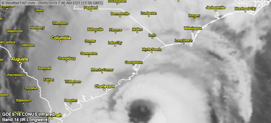
posted by dances_with_sneetches at 6:46 AM on September 5, 2019
Central NC (Raleigh) at 1:13 pm EDT: soft rain falling, very little wind so far.
posted by freecellwizard at 10:14 AM on September 5, 2019
posted by freecellwizard at 10:14 AM on September 5, 2019
Oh my God, I was looking over today's Guardian article on "sharpiegate" and it suddenly dawned on me why Trump said there was a '95% probability chance' (or something like that) Dorian would hit Alabama.
He misread 'Bahamas' as 'Alabama' and ran with it.
And he can't admit that, because he can't allow anyone to realize what a poor reader he is.
But the fact is, the President of the United States is barely literate.
posted by jamjam at 1:34 PM on September 5, 2019 [3 favorites]
He misread 'Bahamas' as 'Alabama' and ran with it.
And he can't admit that, because he can't allow anyone to realize what a poor reader he is.
But the fact is, the President of the United States is barely literate.
posted by jamjam at 1:34 PM on September 5, 2019 [3 favorites]
Y KANT DONNY READ
posted by seanmpuckett at 2:43 PM on September 5, 2019
posted by seanmpuckett at 2:43 PM on September 5, 2019
He's literate but vain and needs glasses:
slate linky
If you're in Publix area - they are currently collecting money for Red Cross that can be added to grocery purchase.
Happy to have escaped the worst here in Fort Lauderdale. Thinking of those that weren't as lucky...
posted by PistachioRoux at 3:09 PM on September 5, 2019
slate linky
If you're in Publix area - they are currently collecting money for Red Cross that can be added to grocery purchase.
Happy to have escaped the worst here in Fort Lauderdale. Thinking of those that weren't as lucky...
posted by PistachioRoux at 3:09 PM on September 5, 2019
Back on our little island in Florida from the mandatory evac, all well. Only thing down is some spanish moss and not too much of that. I hear power went out for an unrelated incident a few days before the storm arrived for an hour or so but was otherwise on the whole time. This after predictions that claimed storm surges in tens of feet. I think the county is getting some heat for pulling the trigger a bit early on sounding the alarm after the thing stopped, hovered, turned, and aligned with the models. It's a tough subject and tougher call but it's making a lot of people talk in terms of 'boy who cried wolf' and that's dangerous when the next storm rolls around.
The business my wife is a partner in probably lost $20k or more in revenue and her employees, with otherwise generous compensation packages and very much living wages, may or may not be paid for those days as they weigh things up and do what they can by them as best they can because absorbing that sort of total loss of income isn't easy and Florida's employee protection requirements are about what you'd expect on the subject. She also hates to leave the myriad of clients who may have mental health needs in a stressed situation on top of all of that.
I hope the Carolinas are doing ok, it looks pretty rough up there and the Bahamas, sheesh, that stop and pivot was... well brutal doesn't even begin to cover it. Is there any analysis that shows pinpoint accuracy of where the eyewall was relative to the island's population centers for that time period, I couldn't help hoping that some portion of them were in the eye for extended periods and, thus, spared some of the pounding/lawnmower type winds that had to be all around them....?
posted by RolandOfEld at 11:04 AM on September 6, 2019 [1 favorite]
Dorian nipped Cape Hatteras for an official U.S. landfall. It is headed to Nova Scotia where it is expected to arrive as a Category 1 hurricane.
The legacy of Dorian is almost unimaginable. The Labor Day Hurricane in 1935 had the record for the worst winds from an Atlantic storm at landfall. Dorian matched that in the Bahamas and stayed at that level for 30 hours.
posted by dances_with_sneetches at 11:16 AM on September 6, 2019 [1 favorite]
The legacy of Dorian is almost unimaginable. The Labor Day Hurricane in 1935 had the record for the worst winds from an Atlantic storm at landfall. Dorian matched that in the Bahamas and stayed at that level for 30 hours.
posted by dances_with_sneetches at 11:16 AM on September 6, 2019 [1 favorite]
Water rises 7 feet in 2 hours in Ocracoke, N.C., as the eye of Hurricane Dorian moves past (Matthew Cappucci, Washington Post)
posted by ZeusHumms at 11:18 AM on September 6, 2019
posted by ZeusHumms at 11:18 AM on September 6, 2019
This is crazy or scarily authoritarian or both: The Trump regime either wrote or pressured someone in NOAA to write a press release disavowing the NWS Alabama tweet from a few days ago pushing back on Trump's statement about Alabama getting hit hard. The press release is only attributed to "a NOAA spokesperson." No-one would sign the thing it's so absurd. So either the Trumpers wrote it themselves and published it under the NOAA header, which is crazy, or they pressured a non-partisan agency responsible for the safety of American life and property into spouting "we've always been at war with East Asia" level lies during a time of emergency.
posted by Justinian at 4:43 PM on September 6, 2019 [3 favorites]
posted by Justinian at 4:43 PM on September 6, 2019 [3 favorites]
This is apparently causing a big problem at NOAA/NWS.
From the NWS EO President: Let me assure you the hard working employees of the NWS had nothing to do with the utterly disgusting and disingenuous tweet sent out by NOAA management tonight.
posted by Justinian at 4:57 PM on September 6, 2019 [8 favorites]
From the NWS EO President: Let me assure you the hard working employees of the NWS had nothing to do with the utterly disgusting and disingenuous tweet sent out by NOAA management tonight.
posted by Justinian at 4:57 PM on September 6, 2019 [8 favorites]
NOAA is a sub-division of the Department of Commerce, whose secretary is Wilbur Ross. I'm guessing that this statement was at the order of Ross. Notice that the title of the release is "Statement Attributable to a NOAA Spokesperson." No one wants to put their name on this propaganda release.
NOAA does not currently have a permanent director, only an "acting" secretary. Trump had nominated Barry Lee Myers, president of AccuWeather, and who is not a scientist. Myers has been an advocate of privatizing the National Weather Service so that his company could profit from it. This is typical of Trump nominating directors for agencies who have pledged to destroy the agency. Also, AccuWeather under Myers leadership has been the subject of a federal investigation for pervasive and severe sexual harassment and retaliation. The nomination has been on hold for months.
It is disconcerting that the very weather forecasts we depend upon have been politicized. They are only allowed to provide the weather forecasts that Trump personally approves.
posted by JackFlash at 6:50 PM on September 6, 2019 [3 favorites]
From rear admiral David Titley, former chief meterologist for the USN and COO of NOAA: Perhaps the darkest day ever for @noaa leadership. Don’t know how they will ever look their workforce in the eye again. Moral cowardice.
Not exactly mincing words.
posted by Justinian at 8:00 PM on September 6, 2019 [5 favorites]
Not exactly mincing words.
posted by Justinian at 8:00 PM on September 6, 2019 [5 favorites]
It's not over just yet. Good luck to our Canadian friends in the maritimes.
Maybe next time Trump can avoid making everything about himself until the death and destruction is over and done with.
posted by wierdo at 9:32 AM on September 7, 2019 [1 favorite]
Maybe next time Trump can avoid making everything about himself until the death and destruction is over and done with.
posted by wierdo at 9:32 AM on September 7, 2019 [1 favorite]
Director of Communications at NOAA is Julie Kay Roberts whose previous job was a director for the Donald J. Trump Inauguration Committee.
It's all about the grift.
posted by JackFlash at 9:36 AM on September 7, 2019 [1 favorite]
It's all about the grift.
posted by JackFlash at 9:36 AM on September 7, 2019 [1 favorite]
Recent buoy readings off Halifax are showing 25+ foot wave heights within a few miles of shore and around 45 feet farther out with wind speeds around 40-50 knots. Really, do take care.
posted by wierdo at 12:36 PM on September 7, 2019 [2 favorites]
posted by wierdo at 12:36 PM on September 7, 2019 [2 favorites]
« Older Don’t spook the Horse: Neil Young previews his new... | Hate is not a hoax Newer »
This thread has been archived and is closed to new comments
Puerto Rico would have slowed down the storm or else broke it up completely. The fact that Dorian made this swing is why it has its terrible potential.
posted by dances_with_sneetches at 6:33 AM on August 30, 2019 [38 favorites]