Keep Direction By Good Methods
February 8, 2021 8:33 PM Subscribe
Before radar, before GPS, the US wanted to fly airmail across the United States, but night flights were dangerous and hard to navigate. Enter WUVHRKDBGM and a system of beacons that flashed those letters (which are also numbers) in Morse Code, with a mnemonic: "When Undertaking Very Hard Routes Keep Direction By Good Methods." The concrete arrows and -- sometimes -- the beacon towers that allowed 1920s pilots to fly through the night across the US persist today, mostly in the West.
Photographer Chris Forsyth has made a project of photographing the remnants of the American transcontinental lighted airway system. Montana maintains three of the beacons in service in the mountainous west part of the state (having cut the rest to great controversy). The rest are all decommissioned.
Archival footage from the San Diego Air and Space Museum. (Turn sound down, it's noisy.)
See photo 5 for what the beacon stations and concrete arrows looked like when in service.
Previously for Concrete Arrows
Although I love having a GPS device in my pocket that will tell me where I need to go, I also love that there was a time when you would just take off in a plane and count on lights and arrows built into the ground to know where you were going. And I would love to hear the excuses from that time—“sorry, hon, I thought the arrow was pointing east-west but it was really pointing north-south.”
posted by ejs at 9:34 PM on February 8, 2021
posted by ejs at 9:34 PM on February 8, 2021
Sigh. This is so cool...
Until it's safe to hit the road again...
posted by Windopaene at 10:54 PM on February 8, 2021 [1 favorite]
Until it's safe to hit the road again...
posted by Windopaene at 10:54 PM on February 8, 2021 [1 favorite]
This is really neat. Thanks!
But, I'm befuddled by the choice of letters. Actual numbers take more time than needed to encode the information. . . but, they also have the advantage that they're numbers and you already know them in order. In the list given, "u" and "b" could be easily confused. Why a "w" and not an "a?" Why an "m" and not a "t?" I really don't get it. If you're "building predictably from dashes to dots and back again" to help people who don't already know code, you could do something much more consistent. It seems like an almost totally random choice. Maybe one of the goals is to avoid any pattern that might be used by an ordinary blinking light? That explains the lack of e and t, but also should make H and M unappealing.
ETANIMSURD is both more efficient and pronounceable. 0123456789 sure seems easier. But, if you really want to encode a four bit number for people who don't already know code, why not just make up your own version? Surely ". . . ." ". . . _" ". . _ ." ". . _ _" etc is easier than something you have to make up a mnemonic about. I'd have done it differently. But, I'm very happy to know about it.
(I'm also very curious what less-polite mnemonics the pilots actually used.)
posted by eotvos at 10:55 PM on February 8, 2021 [3 favorites]
Very interesting. Thanks EM. I am sort of fascinated by logistics. You put a stamp on an envelope, pennies, and viola, 3 **ahem** days later your letter is delivered. When FedEx first started overnight delivery, every single package went to Memphis and back out. Sending a Fedex envelope from the east side to the west side of NY would fly to Memphis and back. It is neat to see the design and how technology has improved it, but airmail is still a huge logistics challenge.
What I did not see (maybe I missed it?) was why a compass and even a sextant did not work at night. Why the need for the arrows? I get the beacons were more accurate in the short run to a compass, but at night, a cement arrow is going to be hard to see in the dark. Nice to have the emergency landing places every 25 miles.
What is also fascinating to me is that all the logistics companies, USPS, UPS, FedEx, DHL, etc. are still trying to solve the last mile issue.
posted by AugustWest at 11:01 PM on February 8, 2021 [2 favorites]
When you sail around southbay by San Jose at night there are multiple lights on the shore that blink differently so you can figure out where you are.
posted by wmo at 11:14 PM on February 8, 2021 [2 favorites]
posted by wmo at 11:14 PM on February 8, 2021 [2 favorites]
Plonking giant concrete arrows and beacon towers across the countryside to help navigate is sort of like plonking arrays of satellites carrying highly accurate clocks into orbit -- modifying the environment in an artificial way to make it easier to navigate. (insert lots of handwaving)
In contrast, there's R&D to develop alternative an navigation system that doesn't depend on artificial landmarks but instead senses fine scale variation in the earth's magnetic field:
> “The high-level motivation,” said Bedford, “is that when we don’t have GPS — and most people agree that if we have a major war, the GPS is going down — we need a different way to navigate.”
> Some alternatives such as star-finders or looking at ground features have obvious limitations. For example, the stars are not visible during the day. The best alternative would be to navigate by sensing Earth’s magnetic field.
> The magnetic field in question is not the “core field”; that is, the field generated by Earth’s iron core. It is the “crustal field.” The core field is constantly in flux. The north and south magnetic poles both wander over time. The crustal field, in contrast, is consistent and, in Bedford’s words, “impossible to spoof.”
-- Mary Pacinda, air force research lab press release, 2020/04 (link has pictures of earth's crustal magnetic field. pretty cool)
posted by are-coral-made at 12:33 AM on February 9, 2021 [2 favorites]
[aside] A similar appropriate tech solution for telling pilots where they were was the WWII construction of 80+ numbered ÉIRE signs associated with manned look out posts LOPs on headlands round the coast of [neutral] Ireland. BBC rediscovery report. Treasa Lynch is curating the data. [/aside back to Utah]
posted by BobTheScientist at 1:09 AM on February 9, 2021 [3 favorites]
posted by BobTheScientist at 1:09 AM on February 9, 2021 [3 favorites]
What I did not see (maybe I missed it?) was why a compass and even a sextant did not work at night. Why the need for the arrows?
One of the links mentions that airplane compasses of the time were "unreliable". I'm guessing they were probably impractical because of a combination of factors like too much vibration from the engine, unpredictable deviation, and planes which (initially, at the beginning of the arrow construction) couldn't fly themselves enough for a pilot to divert their attention to navigation.
That lack of available pilot's attention probably applies to sextants a well. Also, until the bubble sextant was developed specifically for aviation, it would have been difficult to use one in places where mountains prevent measuring the angle to the horizon.
posted by RonButNotStupid at 4:14 AM on February 9, 2021 [2 favorites]
I remember seeing one of these beacons when visiting my grandparents in Palmerton, PA in the 1950s.
Later on there was a radio-based system that pilots could use to home in on an airfield. Don't know what that was called.
posted by SemiSalt at 4:27 AM on February 9, 2021
Later on there was a radio-based system that pilots could use to home in on an airfield. Don't know what that was called.
posted by SemiSalt at 4:27 AM on February 9, 2021
Maybe unsurprisingly, I love old navigation technology. One day I hope to actually spot one of these arrows from the air, but they're all pretty far away from where I live.
why not just make up your own version?
Because there's already a standard for how to arrange dots and dashes? We still, to this day, use Morse to identify radio beacons used for navigation. There are certainly better ways to do it, but it's an agreed-upon way to make distinct identifiers, easy to understand, compact, and universal.
What I did not see (maybe I missed it?) was why a compass and even a sextant did not work at night. Why the need for the arrows?
As mentioned, early compasses (dry compasses) had a tendency to bounce around a lot. Even nowadays with "modern" compass technology, there are a lot of factors that can influence their error:
-Magnetic variation (magnetic north does not coincide with true north) - this is charted and must be factored in when flight planning
-Magnetic deviation (local sources of magnetic influence) - inherent to the design of the aircraft
-Turning effects - unique to each aircraft and even each compass installation in that aircraft; the compass will give an inaccurate reading while in a turn (really in any pitch or roll maneuver), so you have to "roll out" on an indicated heading that's different than your intended heading and then the compass will settle out to yourtrue magnetic heading.
-Wind - weather forecasts weren't as good back then, so factoring wind adjustments in to your planning would have been harder.
As far as sextants go, many planes of this era were high wing and had poor outside visibility, limiting the usefulness of a device that requires you to look up. But they were used! However, you also require a good horizon to use as a reference and that can be difficult to find in hillier terrain.
Later on there was a radio-based system that pilots could use to home in on an airfield. Don't know what that was called.
I'm a little hazy on exact eras, but it could have been one of a couple of systems. "A-N" was one of the earlier radio finding systems, using two signals transmitted in narrow overlapping beams. One signal transmitted Morse "A" (.-) and the other transmitted Morse "N" (-.). You would tune in the frequency and listen to the signal; once you heard a steady tone, you knew you were on the correct course. Hearing more "A" or more "N" meant you were off the course and would need to adjust.
Direction Finding uses AM frequencies and the power of the signal to direct you towards a beacon. This was later upgraded to "Automatic Direction Finding" (ADF) which removed some of the legwork required to get a bearing. More useful in some ways than A-N since it was omnidirectional (A-N only worked within its narrow beam), but it won't help you if you drift off course (it'll still point you towards the beacon, but a strong wind pushing you means you'll end up flying a sort of arced course to the beacon unless you recognize and correct the issue).
VHF Omnidirectional Range (VOR) became more standard in the '60s, and uses two signals - a beacon and a rotating pulse - to allow the user to align with a specific "radial" of their choosing and fly any inbound or outbound course and get drift corrections. These are now finally being phased out in favor of GPS and other RNAV systems, but the government has committed to keeping a skeleton system in place for emergency use.
R&D to develop alternative an navigation system
Yup, and my company is working on several of them! Stellar navigation is getting more attention again, because computers and advanced optics are making it a more attractive option for independent navigation. Newer prototype systems can work in daylight and track not only the stars but our satellite constellation as well.
You can get pretty close to GPS accuracy right now, though, using DME/DME coupled with an inertial system. Distance Measuring Equipment (DME) is another ground based radio system, but all it tells you is how far you are from the transmitter. If you have two of them (DME/DME) in your aircraft, you (a computer, really) can figure out that you're at one of two locations on the map (I know I'm 20 miles from this particular DME station, so I can draw a circle centered around it with a 20 mile radius. Draw something similar for the second station and there are two places where those circles intersect). Knowing your previous location (how? Well, you know where you took off from and you've been tracking your position this whole time...) allows you to eliminate one of the solutions and gives you a fix. So that'll work great on its own, but then you can also feed that into an inertial nav system because it'll do a better job of instantaneous position solutions, but it needs to be corrected every so often to account for drift.
Modern inertial systems for airliners are good for uncorrected navigation (you've lost all your radios and it can't get updates from GPS or DME/DME) for anywhere between 90 minutes and 3 or so hours. They're pretty good!
posted by backseatpilot at 5:35 AM on February 9, 2021 [10 favorites]
why not just make up your own version?
Because there's already a standard for how to arrange dots and dashes? We still, to this day, use Morse to identify radio beacons used for navigation. There are certainly better ways to do it, but it's an agreed-upon way to make distinct identifiers, easy to understand, compact, and universal.
What I did not see (maybe I missed it?) was why a compass and even a sextant did not work at night. Why the need for the arrows?
As mentioned, early compasses (dry compasses) had a tendency to bounce around a lot. Even nowadays with "modern" compass technology, there are a lot of factors that can influence their error:
-Magnetic variation (magnetic north does not coincide with true north) - this is charted and must be factored in when flight planning
-Magnetic deviation (local sources of magnetic influence) - inherent to the design of the aircraft
-Turning effects - unique to each aircraft and even each compass installation in that aircraft; the compass will give an inaccurate reading while in a turn (really in any pitch or roll maneuver), so you have to "roll out" on an indicated heading that's different than your intended heading and then the compass will settle out to your
-Wind - weather forecasts weren't as good back then, so factoring wind adjustments in to your planning would have been harder.
As far as sextants go, many planes of this era were high wing and had poor outside visibility, limiting the usefulness of a device that requires you to look up. But they were used! However, you also require a good horizon to use as a reference and that can be difficult to find in hillier terrain.
Later on there was a radio-based system that pilots could use to home in on an airfield. Don't know what that was called.
I'm a little hazy on exact eras, but it could have been one of a couple of systems. "A-N" was one of the earlier radio finding systems, using two signals transmitted in narrow overlapping beams. One signal transmitted Morse "A" (.-) and the other transmitted Morse "N" (-.). You would tune in the frequency and listen to the signal; once you heard a steady tone, you knew you were on the correct course. Hearing more "A" or more "N" meant you were off the course and would need to adjust.
Direction Finding uses AM frequencies and the power of the signal to direct you towards a beacon. This was later upgraded to "Automatic Direction Finding" (ADF) which removed some of the legwork required to get a bearing. More useful in some ways than A-N since it was omnidirectional (A-N only worked within its narrow beam), but it won't help you if you drift off course (it'll still point you towards the beacon, but a strong wind pushing you means you'll end up flying a sort of arced course to the beacon unless you recognize and correct the issue).
VHF Omnidirectional Range (VOR) became more standard in the '60s, and uses two signals - a beacon and a rotating pulse - to allow the user to align with a specific "radial" of their choosing and fly any inbound or outbound course and get drift corrections. These are now finally being phased out in favor of GPS and other RNAV systems, but the government has committed to keeping a skeleton system in place for emergency use.
R&D to develop alternative an navigation system
Yup, and my company is working on several of them! Stellar navigation is getting more attention again, because computers and advanced optics are making it a more attractive option for independent navigation. Newer prototype systems can work in daylight and track not only the stars but our satellite constellation as well.
You can get pretty close to GPS accuracy right now, though, using DME/DME coupled with an inertial system. Distance Measuring Equipment (DME) is another ground based radio system, but all it tells you is how far you are from the transmitter. If you have two of them (DME/DME) in your aircraft, you (a computer, really) can figure out that you're at one of two locations on the map (I know I'm 20 miles from this particular DME station, so I can draw a circle centered around it with a 20 mile radius. Draw something similar for the second station and there are two places where those circles intersect). Knowing your previous location (how? Well, you know where you took off from and you've been tracking your position this whole time...) allows you to eliminate one of the solutions and gives you a fix. So that'll work great on its own, but then you can also feed that into an inertial nav system because it'll do a better job of instantaneous position solutions, but it needs to be corrected every so often to account for drift.
Modern inertial systems for airliners are good for uncorrected navigation (you've lost all your radios and it can't get updates from GPS or DME/DME) for anywhere between 90 minutes and 3 or so hours. They're pretty good!
posted by backseatpilot at 5:35 AM on February 9, 2021 [10 favorites]
We still, to this day, use Morse to identify radio beacons used for navigation.
It's also used in my favorite hack--racon which uses an active transmitter to pulse a morse code letter back at any radar signal which touches it, creating an identifiable icon at a position on a phosphor radar display long before the technology allowed for such a thing to be done natively.
posted by RonButNotStupid at 6:11 AM on February 9, 2021 [3 favorites]
Old school navigation is no joke. Modern beginning pilots are still taught to be able to figure out where they are from a blind start, assuming even all the electronics are down. Basically try to find a road and follow it to a town, then start looking for airports. And consult that paper chart which of course is right there on the correct page in your lap and not wadded up in the back of the plane at the bottom of a bag somewhere.
But the reality is if you're lost in a plane now and you don't have bigger problems (ie: in bad weather), you're just going to turn your phone on and launch Google Maps. Or Foreflight, assuming you're even slightly prepared.
I believe the FAA still technically has a Flight Navigator certification on the books, although getting one in practice may be hard. The handbook for certification was last updated 2011. Note there's five chapters on using a sextant accurately and just four pages on "NAVSTAR Global Positioning System" of which 2 pages are now esoteric knowledge unnecessary to anyone using modern devices.
posted by Nelson at 6:52 AM on February 9, 2021
Because there's already a standard for how to arrange dots and dashes? We still, to this day, use Morse to identify radio beacons used for navigation. There are certainly better ways to do it, but it's an agreed-upon way to make distinct identifiers, easy to understand, compact, and universal.Taking a system that has meaning and then picking ten symbols from it and ordering them randomly isn't actually taking advantage of Morse code in any way. (Except, perhaps, that if you hire radio operators to run these things by hand, they may have more practiced fists.) Even if you hate the idea of just using Morse code numbers or picking the smallest letters, why not go with ABCDEFGHIJ? It's two dahs less and one dit more than what they chose. [edited because I forgot the J]
posted by eotvos at 7:06 AM on February 9, 2021
On our last cross-country road trip, I absolutely trespassed through a suburban gas distribution field to stand on one of these arrows. I’d been looking forward to it for years. A+, would do again.
posted by mykescipark at 7:29 AM on February 9, 2021 [6 favorites]
posted by mykescipark at 7:29 AM on February 9, 2021 [6 favorites]
Even if you hate the idea of just using Morse code numbers or picking the smallest letters, why not go with ABCDEFGHIJ?
I think you might be overlooking something. Have a look at the progression of letters in morse code:
.-- / ..- / ...- / .... / .-. / -.- / -.. / -... / --. / --
Each successive symbol differs only slightly from the last in an almost predictable way which suggests an ordering. It almost looks like the arbitrary way of encoding 4-bit information you suggested earlier.
Now compare that to your suggestion of ABCDEFGHIJ:
.- / -... / -.-. / -.. / . / ..-. / --. / .... / .. / .---
I don't know if this is the reason they picked WUVHRKDBGM, but it certainly suggests that there's some rationale behind the selection. Morse code already existed, and at the expense of a mnemonic that people may not have even needed to remember if they knew the pattern, it looks like they picked an optimal series of symbols.
posted by RonButNotStupid at 7:46 AM on February 9, 2021 [1 favorite]
I wonder what the construction of this system cost, as a fraction of Federal spending in the '20s. Maybe the operations costs were so much higher that when they could get rid of it nobody cared about sunk cost. Did they run the beacons all night every night? Or was there a schedule?
I can't think of another transcontinental construction project that went obsolete so quickly.
posted by Aardvark Cheeselog at 7:56 AM on February 9, 2021
I can't think of another transcontinental construction project that went obsolete so quickly.
posted by Aardvark Cheeselog at 7:56 AM on February 9, 2021
The reason for picking WUVHRKDBGM is in the second linked article, right at the beginning: One by one, each letter from the string WUVHRKDBGM — whose logic is visual, building predictably from dashes to dots and back again, rather than alphabetic.
posted by migurski at 8:13 AM on February 9, 2021 [3 favorites]
posted by migurski at 8:13 AM on February 9, 2021 [3 favorites]
Dear RonButNotStupid, I don't know if you think of this as a fun, silly, pointless thing to argue about like I do or are feeling insulted. If the later, I'm sorry for being snarky and wish you well.
But, I'm absolutely unconvinced. If the reason to use Morse code is that it's familiar, then using it without either any reference to its meaning or prioritizing small letters is a really weird choice. People who know Morse code (I used to be in the mid-30 words per minute, which is nothing spectacular, but does provide some intuition) map the symbols to letters and numbers immediately. And they already know them in a well-defined order, because they're letters and numbers.
Making pilots memorize a random mnemonic sentence to sort random letters is a very weird choice. You've got an ordered set of morse code numbers. You've got an ordered set of Morse code letters. You've got an ordered set of short morse code letters. You've got a ranked-by-length set of short Morse code letters. You've got actual numeric progressions, rather than some existing symbols that sorta but don't entirely follow one. "Let's start with W and follow it up with a V" is an astonishing choice.
posted by eotvos at 8:15 AM on February 9, 2021
Just because it seems odd to a 2021 Morse code talker doesn't mean all the aviation experts who designed the system in the 1920s were wrong. As Migurski points out the article explains the design. You may not like it but someone sure did. Embrace the quirkiness of it rather than rage about it.
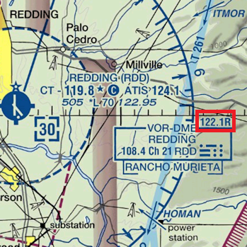
FWIW pilots don't generally know Morse code. I don't think they did back in the 20s either. Very different skillset; even having a radio was a huge luxury back then. Aviation charts are literally printed with the dot and dash patterns for every airport identifer right there on the map: see here for example.
In the one or two times in my life where I tried to decode a VOR-DME Morse code signal I wasn't thinking "Redding is RDD.. let's look on the code chart. OK R is dot dash dot..." I just looked at the map and listened for the exact pattern of dots and dashes printed in it, completely ignorant of the letters they stood for. Because I don't know Morse code. (And I have an international radio operator's license!)
Somewhat related: Four Course Radio Ranges, or A/N navigation. In that case you had two transmitters broadcasting N (dash-dot) or A (dot-dash) in a specific geometric arrangement. If you were flying the straight line between those two signals and tuned them both in, the dots and dashes would merge into a steady tone. Slightly off and you could tell which direction to steer to get back on the line. Basically an audio version of what VORs still do today. Super clever!
I don't think the WUVHRKDBGM coding could be used in a similar way, given the need for two receivers and to be in range of two transmitters. But it's possible.
posted by Nelson at 8:28 AM on February 9, 2021 [2 favorites]
The reason for picking WUVHRKDBGM is in the second linked article, right at the beginning: One by one, each letter from the string WUVHRKDBGM — whose logic is visual, building predictably from dashes to dots and back again, rather than alphabetic.This is true, but the explanation doesn't make any sense. AUV (._, .._, ..._) would be predictable, WUV (.__, .._, ..._) is less so. BDN (_..., _.., _.) would make more sense than BGM (_..., __., __).
(Apologies for derailing a fun thread about a carefree topic by arguing about the details of a decision probably made nearly at random by someone in a hurry a century ago. I think the argument is also fun. And, I fully agree that it doesn't actually matter what they chose. Any option works.)
On preview, A/N navigation sounds really cool.
posted by eotvos at 8:33 AM on February 9, 2021
If you're interested in detailed descriptions of the physical sensations of early mail aviation, Antoine de Saint-Exupery (author of the more famous book 'The Little Prince') also wrote several evocative books about the experiences of piloting mail flights: 'Southern Mail' (1929) and 'Night Flight' (1930), etc.
posted by ovvl at 8:45 AM on February 9, 2021 [1 favorite]
posted by ovvl at 8:45 AM on February 9, 2021 [1 favorite]
Here's a woman (previously) climbing a decommissioned tower.
posted by jackmakrl at 9:12 AM on February 9, 2021 [2 favorites]
posted by jackmakrl at 9:12 AM on February 9, 2021 [2 favorites]
Re: compass/sextant, another thing to consider is that ground markers have side benefits: lighting potential emergency landing areas, but perhaps more importantly making clear which way was down. One of the first things you learn in instrument training as a pilot is how unreliable your sense of orientation is without visual references while flying.
posted by techbasset at 12:01 AM on February 11, 2021 [1 favorite]
posted by techbasset at 12:01 AM on February 11, 2021 [1 favorite]
« Older So many streamable radio stations in the world | Artist's Statement: You got your AI in my MS Paint... Newer »
This thread has been archived and is closed to new comments
posted by BlackLeotardFront at 9:29 PM on February 8, 2021