The Other Big One
August 15, 2022 2:12 AM Subscribe
A megaflood that threatens California and the West Coast, could be the most expensive natural disaster in history. It has happened before, The Great Flood of 1862, caused by an atmospheric river from the Pacific Ocean, first loading the coastal mountains with snow that was then melted by heavy warm rains.
California Megaflood: Lessons from a Forgotten Catastrophe
is an older article from Scientific American, some quotes:
Sixty-six inches of rain fell in Los Angeles that year, more than four times the normal annual amount
In early December, the Sierra Nevada experienced a series of cold arctic storms that dumped 10 to 15 feet of snow, and these were soon followed by warm atmospheric rivers storms.
California’s new Governor, Leland Stanford, was to be inaugurated on January 10, but the floodwaters swept through Sacramento that day, submerging the city. Citizens fled by any means possible, yet the inauguration ceremony took place at the capital building anyway, despite the mounting catastrophe. Governor Stanford was forced to travel from his mansion to the capital building by rowboat.
I'm not skeptical that once a in a lifetime floods happened, it has happened before, but I remember when California was perpetually one earthquake away from being an island. I feel as if we're getting conflicting news of California either turning into the worst desert humanity has ever seen or possibly turning into an ocean. I get that we could have 5 years of the worst drought ever and then a megaflood, that these aren't mutually exclusive, but this feels like an obscure bit of climate science that CNN and the NYT have been running with all week.
We've made a lot of improvements to levies and water management in the last 150 years, but I guess the focus on small incremental improvements doesn't quite grab attention like a scary graphic of the ocean turning Nevada into the West Coast. We can't control the weather, so what is being done to prevent this? Will we know if a flooding event is happening before it happens?
posted by geoff. at 4:29 AM on August 15, 2022 [5 favorites]
The problem is that levies and water management infrastructure is built for a certain level of expected flood risk and that is rising due to climate change. I've heard rumours in the EU for a while now that while we design major transport infrastructure for the "hundred year water" level, a flood with a %1 risk, we should really be designing for at least "five hundred year water" (flood with a .2% risk per year, based on historical data) if not "thousand year water" (.1% risk per year). As Germany found out last year, even well-designed systems can be overwhelmed when as little as half a food of rain falls really fast.
posted by I claim sanctuary at 4:50 AM on August 15, 2022 [16 favorites]
posted by I claim sanctuary at 4:50 AM on August 15, 2022 [16 favorites]
The Corps of Engineers has been working steadily on the Sacramento River flood control project for a hundred years, but I don't think anyone can stop this from happening.
posted by Bee'sWing at 4:53 AM on August 15, 2022 [1 favorite]
posted by Bee'sWing at 4:53 AM on August 15, 2022 [1 favorite]
Will we know if a flooding event is happening before it happens?
43 days of rain would not be an instantaneous event, no. I assume would give folks some bit of time to react.
Desertification - or, as noted in the article, the loss of plant cover through catastrophically large fires - does increase risks of flash flooding, though. In general, plants will slow the flow of any water and diminish the energy content - part of why healthy coastal wetlands are important for hurricane mitigation, for example. Places like Sacramento have been building up their dyke systems to protect against significant floods, but the sort of climate event described in the article would still overwhelm the current flood management structures. Partly that’s an inherent, structural difficulty with trying to manage floods downstream through dykes and similar water containment instead of upstream through having healthy ecosystems.
We can’t control the weather, so what is being done to prevent this?
We can and do influence the climate, however. Stalling global climate change is the most important and effective prevention measure that we could take. Damned little is being done about that so far, unfortunately, though the IRA bill just signed into law will be a step in the right direction.
posted by eviemath at 4:55 AM on August 15, 2022 [8 favorites]
Increased rate of rainfall, which as I claim sanctuary notes is also a risk factor for catastrophic floods, is also a result of climate change - increased energy in our atmospheric systems makes for more intense storms. Same solution: actually addressing climate change effectively.
posted by eviemath at 5:00 AM on August 15, 2022 [2 favorites]
posted by eviemath at 5:00 AM on August 15, 2022 [2 favorites]
4,000 people died in the Great Flood of 1862, and I shudder to think of the lives lost by the next one. Very scary.
posted by tiny frying pan at 5:12 AM on August 15, 2022 [2 favorites]
posted by tiny frying pan at 5:12 AM on August 15, 2022 [2 favorites]
Partly that’s an inherent, structural difficulty with trying to manage floods downstream through dykes and similar water containment instead of upstream through having healthy ecosystems.
For the most part, those upstream restoration projects with flood attenuation benefits have mostly been pursued as small-scale feel-good projects (i.e., good for fish, good for the ecosystem, plus some minor downstream human benefits) but I think we are going to increasingly see them pursued as a cost-effective alternative to, or supplement to, downstream dike and levee system upgrades. Needing to design for more and more extreme events will mean needing to add additional tools that haven't much been needed before.
posted by Dip Flash at 6:24 AM on August 15, 2022 [2 favorites]
Levee system upgrades have definitely not been happening in the places they are needed to prevent a tragedy like this. This is not stupid fearmongering any more than the fact that the Big One (earthquake) is, in fact, still coming. There is a reason I no longer live in California.
posted by branca at 6:28 AM on August 15, 2022 [9 favorites]
posted by branca at 6:28 AM on August 15, 2022 [9 favorites]
Part of the flood mitigation effort upstream from Sacramento is the Oroville Dam, which caused a ripple of anxiety in 2017. The problem with levees and dams is that they have to stay intact. A failed dam is much worse than no-dam-at-all.
We're a long way from California but the idea of warm rain falling on snow brought me back. Ireland got a big dump of snow and icy blasts from Siberia before Christmas 2009. We spent the next month embunkered but slipped out on 14th Jan 2010 to buy provisions [including a crate of Seville oranges for the year's marmalade and a bottle of wine to toast the new year]. In the wee hours, while we slept off the drink, (2.5 in = 6.5 cm) of warm rain fell on a foot of snow and swept our 300m access lane to buggery. It was another three weeks before we drove on the county road again . . . but that won extra jam boiling time.
posted by BobTheScientist at 6:38 AM on August 15, 2022 [9 favorites]
Desertification - or, as noted in the article, the loss of plant cover through catastrophically large fires - does increase risks of flash flooding, though.
We're learning this lesson the hard way in BC.
posted by jacquilynne at 7:26 AM on August 15, 2022 [6 favorites]
We're learning this lesson the hard way in BC.
posted by jacquilynne at 7:26 AM on August 15, 2022 [6 favorites]
Another issue I remember reading about is that the rivers that drain into San Francisco bay were giant reed beds originally. They would flood and deposit sediment, then more reeds would grow on top. It meant that when European farmers settled in the area, they found a thick layer of fabulously fertile topsoil to exploit. Out went the reeds and in came soil loss from flooding and erosion, aggravated by severe subsidence. This led to the farmers building dikes to protect their crops. These dikes are not built to today's engineering standards and are prone to failure.
posted by Bee'sWing at 7:28 AM on August 15, 2022 [7 favorites]
posted by Bee'sWing at 7:28 AM on August 15, 2022 [7 favorites]
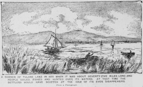
California's Central Valley used to have lakes.
posted by aniola at 8:13 AM on August 15, 2022 [9 favorites]
posted by aniola at 8:13 AM on August 15, 2022 [9 favorites]
We can’t control the weather, so what is being done to prevent this?
Where my in-laws live, they are 'channelizing' a fake flood control channel built in the 1950's as kind a vague river, in that they are deepening it and lining the currently dirt sides with concrete. Seems like an environmental tragedy to me, considering it has only flooded 2 times since 1952, but whatever, and it is sending freshwater directly (mostly) to the ocean. I can't imagine the environmental destruction in terms of wildlife and bugs to protect a few oldish homes and turn something that was kind of nice into an eyesore.
Also, people love to catastroph-ize CA earthquakes, but the truth is the sidewalk in front of their house is stamped by the contractors who built it in 1962, and it's in great condition, like it's brand new. So sure earthquakes happen, a big one may happen sometime in the future, but is it an imminent threat even at the stages of tornadoes in the mid-west? No, it is not.
posted by The_Vegetables at 8:22 AM on August 15, 2022 [1 favorite]
Where my in-laws live, they are 'channelizing' a fake flood control channel built in the 1950's as kind a vague river, in that they are deepening it and lining the currently dirt sides with concrete.
By 'fake', I mean that before they built the subdivision in the 1950s, there was no creek or river there, it was just flat cropland.
posted by The_Vegetables at 8:27 AM on August 15, 2022 [1 favorite]
By 'fake', I mean that before they built the subdivision in the 1950s, there was no creek or river there, it was just flat cropland.
posted by The_Vegetables at 8:27 AM on August 15, 2022 [1 favorite]
Tules! I was trying to remember what the 'reeds' were called. They're a kind of bulrush, it seems, like for Moses transport. Thanks, aniola.
posted by Bee'sWing at 8:45 AM on August 15, 2022
posted by Bee'sWing at 8:45 AM on August 15, 2022
Massive atmospheric river storms like this are fascinating outliers to me. The Omnibus podcast did an episode on ARkStorm, a USGS hypothetical scenario meant to investigate the potential impact of another storm like the 1862 storm, and it opened my eyes to some of the strange weather we have here in California.
Atmospheric rain just isn't like any other rain we get here in California. In a normal rainy season, a "heavy" day of rain is about a half an inch's worth. Pretty mild by most area's standards. But when we are hit by an atmospheric river, the rain can be torrential. The one that hit us last December wasn't super heavy, but even that was over two inches of water in a single day. In bursts, it is as heavy as any rain I ever saw in my 17 years living in Atlanta.
But it's rare! Whole seasons pass without getting hit by one. And usually they only last for a day or two.
But very rarely they last much, much longer, to a degree that beggars belief. The amount rain reported in 1861-2 should silence any talk of mitigation through levees or marsh restoration: ten FEET of rain fell on California in only a month and a half. I've no doubt we should restore the marshlands for a multitude of reasons, but... the USGS doesn't model ARkStorm to sell people on marshland restoration or levee system repair. (see this amazing picture of the scope we're talking about) Levees reportedly made things worse for Sacramento in 1862: they had to tear down the levee to drain the city center.
Anyway, I think it's fascinating. But I can't blame folks who left California to stop worrying about this kind of thing!
posted by billjings at 9:09 AM on August 15, 2022 [6 favorites]
Will we know if a flooding event is happening before it happens?
The basic problem is that the infrastructure improvements needed to mitigate catastrophe take:
Meanwhile the advance warning on this sort of atmospheric river is on the order of days, per that NYT article: "Forecasters can now spot incoming atmospheric rivers five days to a week in advance, though they don’t always know exactly where they’ll hit or how intense they’ll be." And even with advance warning, people won't evacuate their homes or give up their jobs just because someone in the government said they should. They might have to see the flood waters themselves, by which time evacuation may be difficult if not impossible.
posted by fedward at 9:38 AM on August 15, 2022 [5 favorites]
The basic problem is that the infrastructure improvements needed to mitigate catastrophe take:
- Political will, difficult when there's a large voting bloc that denies anthropogenic climate change even exists, much less that it has extreme associated risks;
- Lifestyle changes up to and including mass relocations, difficult to impossible given the lack of political will;
- An incredible amount of money; and
- Decades of work.
Yet California officials have downplayed these concerns about the capacity of Oroville’s emergency spillway, which were raised by the Federal Energy Regulatory Commission. Such extreme flows are a “remote” possibility, they argued in a letter last year. Therefore, further upgrades at Oroville aren’t urgently needed.The article also highlights a catch-22 situation with strengthening levees, in that after that sort of infrastructure improvement more people will want to move into the area protected by a levee. That's both good (increasing the tax base helps pay for the improvements) and bad (more people living in the protected area means more people at risk in a catastrophic event).
In a curt reply last month, the commission said this position was “not acceptable.” It gave the state until mid-September to submit a plan for addressing the issue.
Meanwhile the advance warning on this sort of atmospheric river is on the order of days, per that NYT article: "Forecasters can now spot incoming atmospheric rivers five days to a week in advance, though they don’t always know exactly where they’ll hit or how intense they’ll be." And even with advance warning, people won't evacuate their homes or give up their jobs just because someone in the government said they should. They might have to see the flood waters themselves, by which time evacuation may be difficult if not impossible.
posted by fedward at 9:38 AM on August 15, 2022 [5 favorites]
I'm not sure that it would even really be feasible to prepare for this to an extent that might actually result in significant benefit. The existing system is stressed if multiple parts of California have a wet winter simultaneously as it is. Multiplying storage capacity by 3 or 4x in the face of shrinking snow melt is a tremendous problem, because it would require the creation of an entirely new set of reservoirs closer to the coast, downstream of existing systems and designed to be able to handle enormous overflow events like this while remaining mostly unused otherwise. Expanding the existing system seems like a non-starter. You're not going to add significant capacity to the Big Creek project or other similar ones in the southern and central Sierra Nevada. The era of significant public works in the Sierra Nevada is probably over in general, aside from transit and minor infrastructure. A new dam would be another Hetch Hetchy and I can't see it except possibly way up north in an area desperate for the economic transformation it could represent.
posted by feloniousmonk at 10:10 AM on August 15, 2022
posted by feloniousmonk at 10:10 AM on August 15, 2022
So sure earthquakes happen, a big one may happen sometime in the future, but is it an imminent threat even at the stages of tornadoes in the mid-west?
Geologically, it is quite imminent indeed.
We know the San Andreas Fault will strike again and significantly impact all civilization within a 50-100 mile radius. According to USGS there is a 70% chance that one or more quakes of a magnitude 6.7 or larger will occur before the year 2030.
posted by tiny frying pan at 10:26 AM on August 15, 2022 [4 favorites]
in that they are deepening it and lining the currently dirt sides with concrete
Bad, bad, bad idea - don’t these people ever talk to each other?? Isn’t there an impact study required on these things?
Parts of New Mexico did this with their acequia irrigation ditches a while back to cut down on the annual ditch maintenance (pulling weeds) and water table levels have dropped and wells dried up, so they’re removing the concrete and going back to soil-embanked ditches. Turns out that simply running water through the ditches during irrigation season was enough to keep the water tables at a useable level.
posted by Silvery Fish at 10:55 AM on August 15, 2022 [5 favorites]
Yeah, channelizing is the exact sort of thing that has us in this mess. It quickly and efficiently gets the water out of your neighborhood--and downstream to the next neighborhood. So by preventing local flooding, you increase the likelihood of downstream flooding. The way to safely protect from flooding is with space. "Horizontal levees" or transition zones, with wetlands, give water space to spread and slow, losing energy, and preventing downstream flooding. They also provide tons of other benefits--aquifer recharge, habitat for wildlife, carbon sequestration, and so on. The problem is that we used that space decades ago, and now people don't want to retreat from their valuable real estate to make room for nature to handle this problem.
posted by agentofselection at 11:03 AM on August 15, 2022 [7 favorites]
posted by agentofselection at 11:03 AM on August 15, 2022 [7 favorites]
just your regular reminder from out here in Oakland that California is a hellscape of natural disasters, celebrities, and leftists and you should definitely not move here. It's hard enough to get a reservation at Sobre Mesa as it is.
posted by turbowombat at 11:11 AM on August 15, 2022 [8 favorites]
posted by turbowombat at 11:11 AM on August 15, 2022 [8 favorites]
The way to safely protect from flooding is with space. "Horizontal levees" or transition zones, with wetlands, give water space to spread and slow, losing energy, and preventing downstream flooding.
There's an area just west of us with dozens of soccer fields and tennis courts, an radio controlled vehicle field, a shooting range and a couple of playgrounds and picnic areas. When it rains, it floods, which is the point. It's a place for a whole bunch of water to go. New developments also have to have drainage areas to hold x amount of water, depending on how much land you've covered in asphalt or cement.
We're in what used to be the country, so it wasn't too hard to do this from the get go. I have no idea how you'd retrofit it into a dense city.
posted by Spike Glee at 11:56 AM on August 15, 2022 [1 favorite]
We know the San Andreas Fault will strike again and significantly impact all civilization within a 50-100 mile radius. According to USGS there is a 70% chance that one or more quakes of a magnitude 6.7 or larger will occur before the year 2030.--tiny frying pan
The San Francisco Bay Area, and the Los Angeles Basin (380 miles southeast) both have a greater than 50% chance of a major > 6.7 magnitude earthquake, according to the USGS.
posted by eye of newt at 12:13 PM on August 15, 2022
The San Francisco Bay Area, and the Los Angeles Basin (380 miles southeast) both have a greater than 50% chance of a major > 6.7 magnitude earthquake, according to the USGS.
posted by eye of newt at 12:13 PM on August 15, 2022
New developments also have to have drainage areas to hold x amount of water, depending on how much land you've covered in asphalt or cement.
We're in what used to be the country, so it wasn't too hard to do this from the get go. I have no idea how you'd retrofit it into a dense city.
Solutions like that are terrible and the low quality 'cheap' way to infiltrate water. Cities build gigantic underground water containment areas. They are also temporary as they fill with silt.
Houston former cistern you can tour
Japan
Dallas
St Louis
posted by The_Vegetables at 12:25 PM on August 15, 2022
I have no idea how you'd retrofit it into a dense city.
People joke about Rotterdam, mm, using WWII to make room for the river, but it’s officially described as a response to 1990s floods so maybe not. And LA is looking at Rotterdam’s changes to make plans.
A huge earthquake or flood might also be an opportunity, but in the event there’s such a huge impulse to build back just the same. Some kind of "this much disaster and you get money but you have to leave" insurance, maybe.
posted by clew at 2:27 PM on August 15, 2022
California was perpetually one earthquake away from being an island. I feel as if we're getting conflicting news of California either turning into the worst desert humanity has ever seen or possibly turning into an ocean.
I am reminded of that Simpsons scene where it is explained to Burns that all his diseases impede one another from offing him, as if they were all fighting to pass through a single door.
posted by pwnguin at 2:29 PM on August 15, 2022
I am reminded of that Simpsons scene where it is explained to Burns that all his diseases impede one another from offing him, as if they were all fighting to pass through a single door.
posted by pwnguin at 2:29 PM on August 15, 2022
New developments also have to have drainage areas to hold x amount of water, depending on how much land you've covered in asphalt or cement.
Yeah, these retention or detention basins capture and hold a given amount of water, but they don't absorb the energy or provide the other benefits of a transitional flood plain. It's easy enough to engineer a detention basin that can catch and hold a 20-year, 50-year, 100-year flood, but the situation we are hitting now is that those solutions are under-engineered for the conditions we are actually seeing, and when they fail, they fail badly rather than gradually.
posted by agentofselection at 2:35 PM on August 15, 2022 [2 favorites]
California's Central Valley used to have the largest body of water west of the Mississippi, and now there's lots of people living there. It's the part of California with a relatively affordable cost of living. It's the part of California that they drained and filled in with impossibly-large "farms". People write books about this region entitled things like "They leave their kidneys in the fields."
In 1875 it looked like this. In 1898 it looked like this. In 2022 it looks like this. Who is this megaflood going to impact the most? What do we (you and I, readers of this post) do today to minimize the impact of this megaflood tomorrow? It could look like this, but who's working on it? (Not this couple, I'm guessing.)
I think one thing some people in other regions* can do is take a close look at what food they're getting from California, and how they can support ecologically-appropriate local replacements. I'm sure there's many other answers as well, this is just one of many possible angles. What else can you come up with?
posted by aniola at 3:08 PM on August 15, 2022 [7 favorites]
Incidentally, rain on snow is what caused the recent disastrous flooding in northern Yellowstone up into the Paradise Valley.
posted by traveler_ at 3:22 PM on August 15, 2022 [2 favorites]
posted by traveler_ at 3:22 PM on August 15, 2022 [2 favorites]
That Mother Jones article has a lot of info.
posted by Oyéah at 6:38 PM on August 15, 2022 [1 favorite]
posted by Oyéah at 6:38 PM on August 15, 2022 [1 favorite]
For ease of finding, this is the Mother Jones article.
posted by aniola at 6:46 PM on August 15, 2022 [2 favorites]
posted by aniola at 6:46 PM on August 15, 2022 [2 favorites]
It’s totally possible to have floods in a desert, nb. The Atacama just did. It’s less usual to have someplace dry out so completely that all the plants die between floods every year, but it’s possible. Lots of the hotter parts of California used to be flowering vernal pools in winter and spring, and then not much but tarweed in the summer.
The edges of the Atacama also flower after rains. I think the Gobi and Taklamakan and drier Sahara might be dry enough to not have endemic plants, or few and tough. You wouldn’t want to rely on agriculture in any of those places, though.
posted by clew at 7:08 PM on August 15, 2022 [1 favorite]
The edges of the Atacama also flower after rains. I think the Gobi and Taklamakan and drier Sahara might be dry enough to not have endemic plants, or few and tough. You wouldn’t want to rely on agriculture in any of those places, though.
posted by clew at 7:08 PM on August 15, 2022 [1 favorite]
Solutions like that are terrible and the low quality 'cheap' way to infiltrate water. Cities build gigantic underground water containment areas. They are also temporary as they fill with silt.
Houston former cistern you can tour
Japan
Dallas
St Louis
Chicago has this as well. It's called the Deep Tunnel. EPA mandated as the rain and waste sewage are not properly separate systems and people downriver were tired of being flooded with Chicago shit after more than about a hundred years of Chicago River reversal. Now a large amount of what would have been sewer overflow is diverted to a massive repurposed quarry so it can be treated at a more leisurely pace after a big rainfall. A while back there was a hilarious video of some giant air vents flapping set to music posted online. They were rhythmically releasing the air pressure built up by a big rainstorm's water flooding the tunnel causing rubber cover laps to lift.
posted by srboisvert at 7:29 PM on August 15, 2022
According to USGS there is a 70% chance that one or more quakes of a magnitude 6.7 or larger will occur before the year 2030.
Not that it invalidates the broader point, but I do want to note that the source is from 1999, and represents a 30-year forecast (as opposed to 8 years). The current 30-year forecast is about the same -- no need to make sure you're out of town for New Year's Eve in 2029 if the big one hasn't struck yet.
posted by aws17576 at 8:53 PM on August 15, 2022 [1 favorite]
It's the part of California with a relatively affordable cost of living. It's the part of California that they drained and filled in with impossibly-large "farms".
It's the part of California that's hot at balls.
posted by kirkaracha at 9:58 PM on August 15, 2022
It's the part of California that's hot at balls.
posted by kirkaracha at 9:58 PM on August 15, 2022
Yes? That's how earthquake science works - looking at historical earthquakes and tremors and understanding the rates at which they occur.
The USGS site remarks over and over again that they do not make specific predictions.
posted by tiny frying pan at 4:45 AM on August 16, 2022 [1 favorite]
The USGS site remarks over and over again that they do not make specific predictions.
posted by tiny frying pan at 4:45 AM on August 16, 2022 [1 favorite]
Right, it sounds like we both understand the science. My point was simply that the USGS statement you pasted into your comment, in present tense, was accurate when it was made in 1999. Saying in 2022 that "there is a 70% chance that one or more quakes of a magnitude 6.7 or larger will occur before the year 2030" dramatically overstates the likely imminence, because the 30-year horizon has since moved out to 2052 or so. (Not that this correction gives me much comfort as a California homeowner. 2052 is still plenty soon enough to worry about, and, of course, it's just as likely that the quake will happen in 2023 as in 2052. But the annual risk is about one-quarter of what your comment implied.)
posted by aws17576 at 8:33 AM on August 16, 2022 [1 favorite]
posted by aws17576 at 8:33 AM on August 16, 2022 [1 favorite]
My point was simply that the USGS statement you pasted into your comment, in present tense, was accurate when it was made in 1999.
That seems like bad statistics presentation to me. If no large earthquake anywhere near southern CA has struck since 1999 (there was 7.1 way out in the desert in 2019) then a yearly statistic would be of more value and more understandable to the average person than rolling 30 year predictions.
posted by The_Vegetables at 8:40 AM on August 16, 2022
Erm. I don’t know anything about earthquake predicting, so the following may not entirely apply for reasons of how the calculations may be reported - eg. animalizing things in different ways. But one way to compute the probability of major earthquake before 2030 might, depending on how the 70% figure was arrived at in the first place or what exactly they meant by it, use a conditional probability calculation. That would go as follows: if we know that there is a 70% chance of event X happening in the time range from 2000 to 2030, and we’re given that event X hasn’t happened yet by 2022, then to obtain the probability that event X happens in the 2023 to 2030 time range we would compute:
Prob( event X occurs given that event Y occurred ) = prob( event X and event Y both occur ) / prob( event X occurs )
In this case, event Y is the probability that event X did not occur from 2000 to 2022.
In other words, it’s plausible that the probability of a major quake before 2030 is now higher given that it didn’t occur previously.
posted by eviemath at 9:13 AM on August 16, 2022
(But also plausible that it isn’t - again, depends on how the original probability estimate for the whole time span was arrived at.)
posted by eviemath at 9:14 AM on August 16, 2022
posted by eviemath at 9:14 AM on August 16, 2022
It's the part of California that's hot at balls.
Yep! What does draining a wetlands do to a local climate? And poisoned. That's why it's relatively affordable. I get the impression we can also blame industrial agriculture for valley fever.
But for a lot of people, it's home right now. And massive former wetlands are going to be the regions that flood when a megaflood hits. I couldn't find a historic map, but that's a lot of California.
According to the study,* areas that have been hit by wildfires will also be harder hit by floods.
*When I went searching for California megaflood information, I got a flurry of articles all written in the past few days. One of them referenced a study that just came out. The study ends on a hopeful note. They've made recommendations and they're working on it.
posted by aniola at 10:23 AM on August 16, 2022
Yep! What does draining a wetlands do to a local climate? And poisoned. That's why it's relatively affordable. I get the impression we can also blame industrial agriculture for valley fever.
But for a lot of people, it's home right now. And massive former wetlands are going to be the regions that flood when a megaflood hits. I couldn't find a historic map, but that's a lot of California.
According to the study,* areas that have been hit by wildfires will also be harder hit by floods.
these events may potentially exhibit some degree of predictability at seasonal scale. For these reasons, we emphasize that recognizing and mitigating the societal risks associated with this subtly but substantially escalating natural hazard is a critically important consideration from a climate adaptation perspective.There's nowhere to run. It's all the same planet. All that's left is to fix things.
*When I went searching for California megaflood information, I got a flurry of articles all written in the past few days. One of them referenced a study that just came out. The study ends on a hopeful note. They've made recommendations and they're working on it.
posted by aniola at 10:23 AM on August 16, 2022
there are A LOT of...cows too. in the Central Valley. lotsa cows. the amount of food grown and pastured inside that potential flood zone is horrific and very concerning...
posted by supermedusa at 10:28 AM on August 16, 2022 [1 favorite]
posted by supermedusa at 10:28 AM on August 16, 2022 [1 favorite]
Incidentally, rain on snow is what caused the recent disastrous flooding in northern Yellowstone up into the Paradise Valley.
Practical Engineering covers this today!
posted by Bee'sWing at 1:53 PM on August 16, 2022
Practical Engineering covers this today!
posted by Bee'sWing at 1:53 PM on August 16, 2022
OK, it’s admittedly a tangent, but I want to make one more attempt to address the probability/forecasting thing in more depth because I find it really interesting! To be upfront, I know a lot more about math than seismology, and I’d like to hear from anyone who can bring me more up to date on the latter.
Actually, let me start with megafloods in California, in the spirit of staying on the main topic of the thread. (Much of this will be broadly applicable to quakes too.) Wikipedia says:
Imagine that $deity is rolling a 150-sided die each winter, and when a 1 comes up, we get a megaflood. In that case, the annual risk never changes—it’s 1 in 150, regardless of the amount of time since the last flood. Forecasting is impossible in this scenario, except in the actuarial sense: we can quantify the risk but we never gain any information. A “memoryless” process like this is called a Poisson process [obligatory note for pedants that the die is discrete-time and a Poisson process is continuous-time, but never mind that].
It’s plausible that California megafloods could be a Poisson process—though in light of climate change, this process would probably be nonstationary (i.e. the likelihood of occurrence is going up but there is still no “memory” of when the last one occurred, no mechanism for “coming due”). It’s also plausible that megafloods are not a Poisson process, given that we know climate involves cycles on various time scales. And it’s possible that they aren’t Poisson but we don’t currently have the knowledge to model them better. For this particular series, there are only ten data points, not a lot to validate one model over another. In this case, if the Poisson process is a reasonable fit, then its memorylessness makes it the parsimonious choice.
We’re in a similar situation with regard to earthquakes, with one big caveat: a recent quake is predictive of more quakes in the short term, because clusters/sequences of aftershocks are a thing. But if we carefully identify “related quakes” and treat them as one event, then maybe earthquakes on a given fault are a Poisson process. See e.g. this paper with an amusing one-word abstract.
On the other hand, that paper concludes by saying that while Southern California quakes at magnitude greater than 3.8, 4.3, 4.8, and 5.3 were well-modeled as Poisson processes, there weren’t enough quakes with magnitude above 5.8 to draw conclusions. And those very large quakes might follow their own rules! Every Californian has heard that strain builds on a fault until an earthquake relieves it. Small quakes unfortunately don’t provide enough relief to matter. But for the largest quakes, perhaps that strain is a mechanism by which there is memory in the system, and quakes do come “due”. In that case, the Poisson model wouldn’t apply.
The trouble is that as far as I have read, there is still no working model that is actually more predictive than Poisson. So for now, the USGS’s 30-year probabilities don’t change much over time. A USGS publication from 1999 puts the risk of an over-6.7 quake in the Bay Area from 2000 to 2030 at 70%; the current figure on the USGS website for “the next 30 years” is 72%.
posted by aws17576 at 5:06 PM on August 16, 2022 [3 favorites]
Actually, let me start with megafloods in California, in the spirit of staying on the main topic of the thread. (Much of this will be broadly applicable to quakes too.) Wikipedia says:
USGS sediment research in the San Francisco Bay Area, Santa Barbara Basin, Sacramento Valley, and Klamath Mountain region found that "megastorms" similar to the ARkStorm scenario have occurred in the following years (C.E.): 212, 440, 603, 1029, circa 1300, 1418, 1605, 1750, 1810, and, most recently, 1861–1862. Based on the intervals of known occurrences, ranging from 51 to 426 years, scientists have concluded that these events have a mean return period of about 150–200 years.Now, one might look at the 150–200 year mean return period, notice that it has been over 160 years since the last megaflood, and conclude that we’re “due” for the next one. However, the wide range of intervals (from 51 to 426 years) casts doubt on our ability to turn this into a meaningful forecast. Worse than that, it may be the case that the whole concept of being “due” is totally unfounded. In fact, there are reasons to take that as our baseline assumption.
Imagine that $deity is rolling a 150-sided die each winter, and when a 1 comes up, we get a megaflood. In that case, the annual risk never changes—it’s 1 in 150, regardless of the amount of time since the last flood. Forecasting is impossible in this scenario, except in the actuarial sense: we can quantify the risk but we never gain any information. A “memoryless” process like this is called a Poisson process [obligatory note for pedants that the die is discrete-time and a Poisson process is continuous-time, but never mind that].
It’s plausible that California megafloods could be a Poisson process—though in light of climate change, this process would probably be nonstationary (i.e. the likelihood of occurrence is going up but there is still no “memory” of when the last one occurred, no mechanism for “coming due”). It’s also plausible that megafloods are not a Poisson process, given that we know climate involves cycles on various time scales. And it’s possible that they aren’t Poisson but we don’t currently have the knowledge to model them better. For this particular series, there are only ten data points, not a lot to validate one model over another. In this case, if the Poisson process is a reasonable fit, then its memorylessness makes it the parsimonious choice.
We’re in a similar situation with regard to earthquakes, with one big caveat: a recent quake is predictive of more quakes in the short term, because clusters/sequences of aftershocks are a thing. But if we carefully identify “related quakes” and treat them as one event, then maybe earthquakes on a given fault are a Poisson process. See e.g. this paper with an amusing one-word abstract.
On the other hand, that paper concludes by saying that while Southern California quakes at magnitude greater than 3.8, 4.3, 4.8, and 5.3 were well-modeled as Poisson processes, there weren’t enough quakes with magnitude above 5.8 to draw conclusions. And those very large quakes might follow their own rules! Every Californian has heard that strain builds on a fault until an earthquake relieves it. Small quakes unfortunately don’t provide enough relief to matter. But for the largest quakes, perhaps that strain is a mechanism by which there is memory in the system, and quakes do come “due”. In that case, the Poisson model wouldn’t apply.
The trouble is that as far as I have read, there is still no working model that is actually more predictive than Poisson. So for now, the USGS’s 30-year probabilities don’t change much over time. A USGS publication from 1999 puts the risk of an over-6.7 quake in the Bay Area from 2000 to 2030 at 70%; the current figure on the USGS website for “the next 30 years” is 72%.
posted by aws17576 at 5:06 PM on August 16, 2022 [3 favorites]
there are A LOT of...cows too. in the Central Valley. lotsa cows. the amount of food grown and pastured inside that potential flood zone is horrific and very concerning...
Since there seem to be people interested in statistics in the room, can someone tell me exactly how much shit this would be, by volume?
posted by aniola at 5:43 PM on August 16, 2022
Since there seem to be people interested in statistics in the room, can someone tell me exactly how much shit this would be, by volume?
posted by aniola at 5:43 PM on August 16, 2022
I suppose the more useful statistic would be something like, what would the fecal coliform numbers be like during/after a megaflood?
posted by aniola at 5:45 PM on August 16, 2022 [1 favorite]
posted by aniola at 5:45 PM on August 16, 2022 [1 favorite]
Cattle produce 1011 fecal coliforms every day. There are nearly 4 million head in the Central Valley. So something like 1018 fresh [<3 days old] fecal coliforms will be swilling in the soup. How much soup? 1862 flooded 500 x 30 km of the Central Valley to a depth of 1m. That's 1016 ml loaded with 100 coliforms per ml. The red flag TNTC [too numerous to count] for detection on tested well-water is 2 coliforms per ml.
posted by BobTheScientist at 12:00 AM on August 17, 2022
posted by BobTheScientist at 12:00 AM on August 17, 2022
I hadn't even thought of the disease angle re the cows, just the impossibility of relocating that many living bodies. so food shortages & diseases, fun fun!
posted by supermedusa at 12:28 PM on August 17, 2022
posted by supermedusa at 12:28 PM on August 17, 2022
None of our floods are considered clean - it’s 90 to 120 days before you can sell crops out of a flooded field, depending on type of crop.
posted by clew at 1:58 PM on August 17, 2022
posted by clew at 1:58 PM on August 17, 2022
« Older M A R V E D Y N E | If you think this thread is bad now, wait 'til I... Newer »
This thread has been archived and is closed to new comments
The only way to fix it is to flush it all away
Any fucking time, any fucking day
Learn to swim, I'll see you down in Arizona Bay
Tool - 'Aenema'
posted by GallonOfAlan at 4:09 AM on August 15, 2022 [13 favorites]