Homemade Earth
March 27, 2006 4:16 AM Subscribe
Artificial images of our real planet : computer-generated Earth views and panoramas, all created using various free tools and resources, including the Blue Marble and USGS datasets, POV-Ray and the Gimp. CGI Mount Saint Helens vs the real thing. For truly artificial landscapes, see also the randomly-generated Landscape of week from the same author.
What a wonderful collection of resources, each of which would make a good post, together they're fantastic, thanks.
One side-effect, it's sharpened some dissatisifaction with Google Earth. Any tips for improving the quality of perspectives like this would be most welcome - for example is it possible to remove the 'patchwork quilt' effect caused by different resolutions? Although it's never going to give great quality views, its interactive aspect makes it a thing of utter beauty
posted by grahamwell at 6:28 AM on March 27, 2006
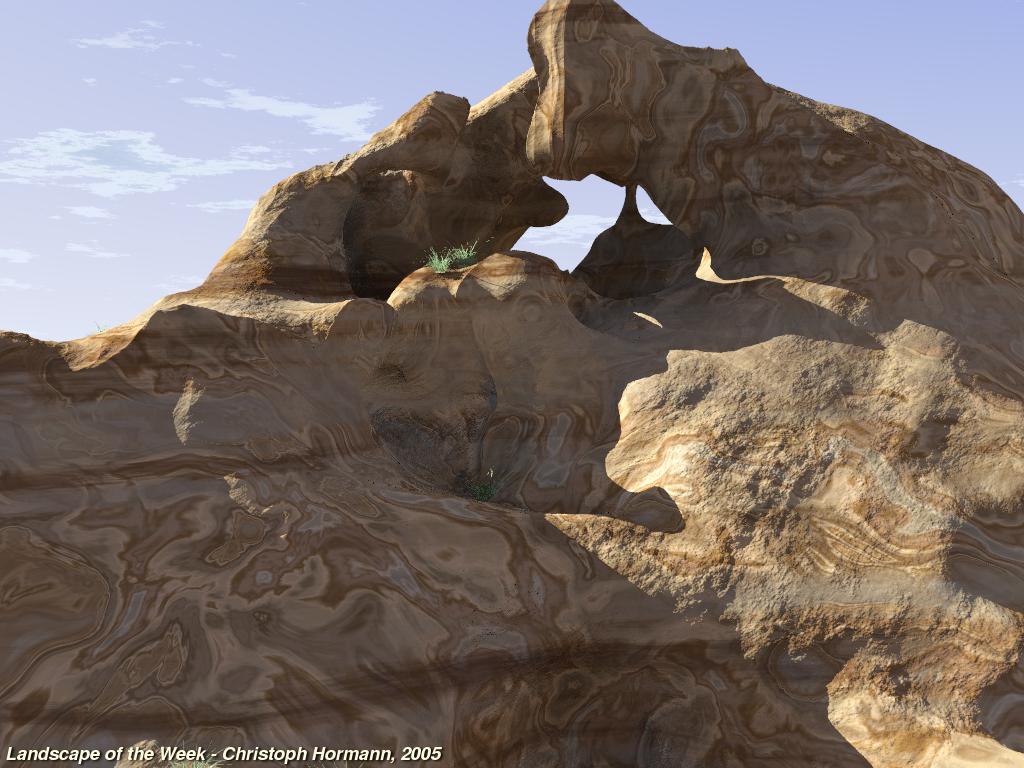
the only issue I have with these types of renderings is that they don't do overhangs at all. Thankfully, the overwhelming majority of the earth's surface doesn't demonstrate any overhang formations at this scale, so it doesn't matter for so much of the material. But if you know of any famous gigantic overhanging cliffs anywhere, and you go to look at a rendering of it from any of these resources, you'll notice it doesn't look quite right.
but also, this is a great post. thanks.
posted by shmegegge at 7:15 AM on March 27, 2006
but also, this is a great post. thanks.
posted by shmegegge at 7:15 AM on March 27, 2006
They also don't show trees and other living-organic features, there is a very sterile quality. Kind of like NASA renderings of Mars. But still very cool.
posted by stbalbach at 7:20 AM on March 27, 2006
posted by stbalbach at 7:20 AM on March 27, 2006
Yes, very cool. I hadn't thought about it before reading stbalbach's comment, but that was something that was at the back of my mind. It's especially visible in the landscape of the week, where the renders are from a much lower perspective.
posted by OmieWise at 7:39 AM on March 27, 2006
posted by OmieWise at 7:39 AM on March 27, 2006
Omniewise: It's especially visible in the landscape of the week, where the renders are from a much lower perspective.
Actually, some of the Landscape of the week pics do show some overhangs and plants (in fact some of them even show loose rocks floating over the ground) (see also this one from the POV-Ray Hall of fame). The technique used here allows for overhangs but in the case of topography-based images the original data do not contain such information.
posted by elgilito at 8:00 AM on March 27, 2006
.
posted by russilwvong at 8:40 AM on March 27, 2006
posted by russilwvong at 8:40 AM on March 27, 2006
This is an excellent, excellent post. Thank you so very much elgilito. This is what I love about Metafilter. I could look at these things for days.
posted by dios at 10:09 AM on March 27, 2006
posted by dios at 10:09 AM on March 27, 2006
elgilito, my comment certainly wasn't a criticism of the post or the technique or anything, it was simply a nod to the limitations. And although the pics you linked had some flora, on the whole they tended to support my contention, because they were predominantly rock formations. I like the post. Thanks.
posted by OmieWise at 10:50 AM on March 27, 2006
posted by OmieWise at 10:50 AM on March 27, 2006
Wow, so it´s something of a hand-crafted GoogleEarth? Cool, even if you cannot fly over it.
posted by Laotic at 11:09 AM on March 27, 2006
posted by Laotic at 11:09 AM on March 27, 2006
« Older Who gets married these days? | 'Study, study, and study, to overtake and surpass... Newer »
This thread has been archived and is closed to new comments
posted by Mave_80 at 5:21 AM on March 27, 2006