Mapping Kibera
January 18, 2011 9:46 AM Subscribe
Kibera is a slum in the southwest of Nairobi, often called the biggest slum in the world; some estimates of the population put it as high as 1.5m, although the 2009 Kenyan census puts the population at a rather more sober 170k(ish). Now, Kiberans are carrying out two similarly named but unaffiliated projects, Map Kibera and Map Kibera Project, to create maps of their home. MKP has a pair of rather slick-looking PDF maps showing the terrain and structures in Kibera. MK uses OpenStreetMap, which means that their cartographers can be rapidly update it to more accurately reflect how quickly things change in Kibera. They also have, inevitably, a twitter account, flickr stream and a blog to keep the world up to date with their work, including their ambition to start mapping another Nairobi slum, Mathare.
Via the Beeb, which also has a nice wee audio slideshow about MK.
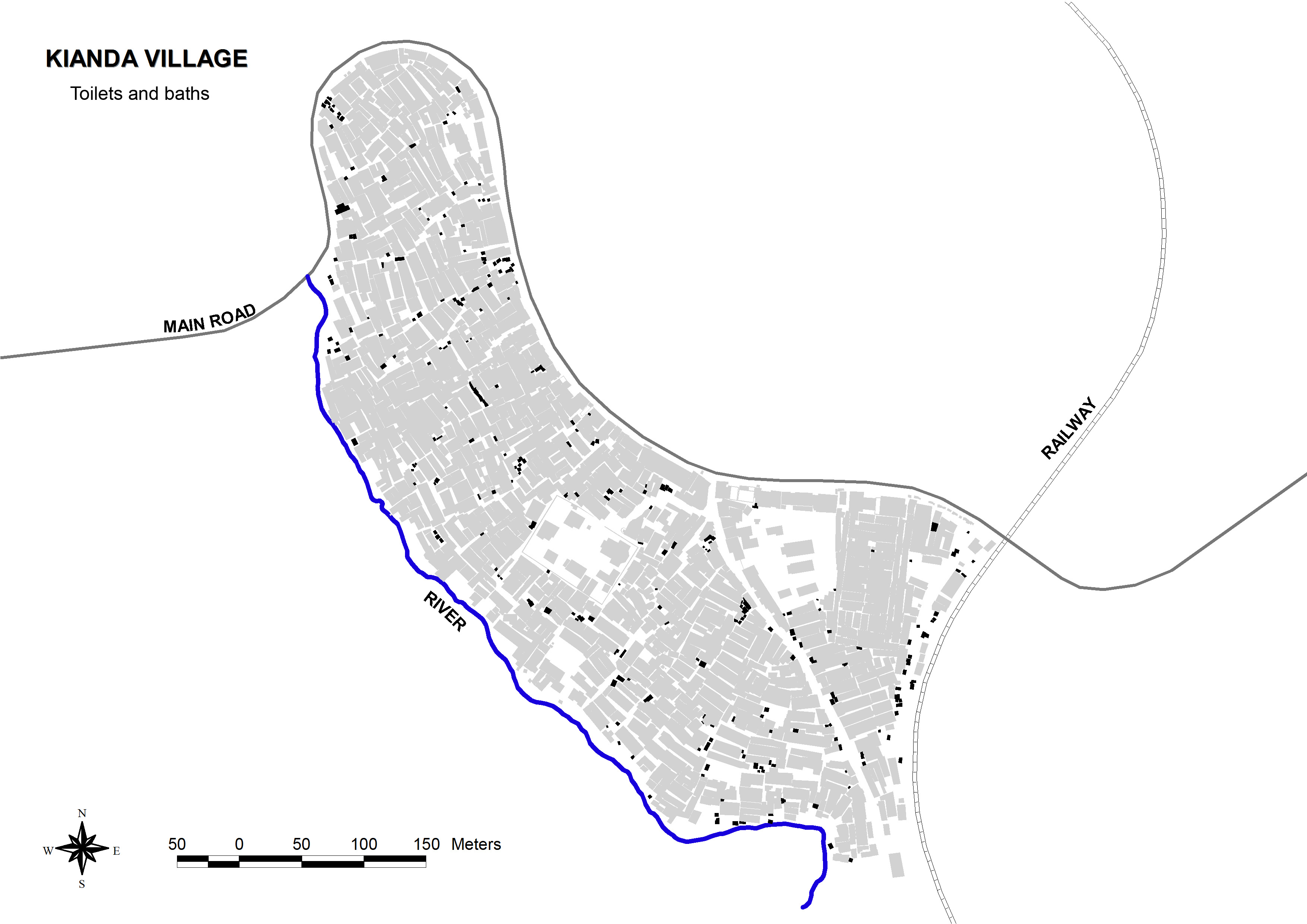
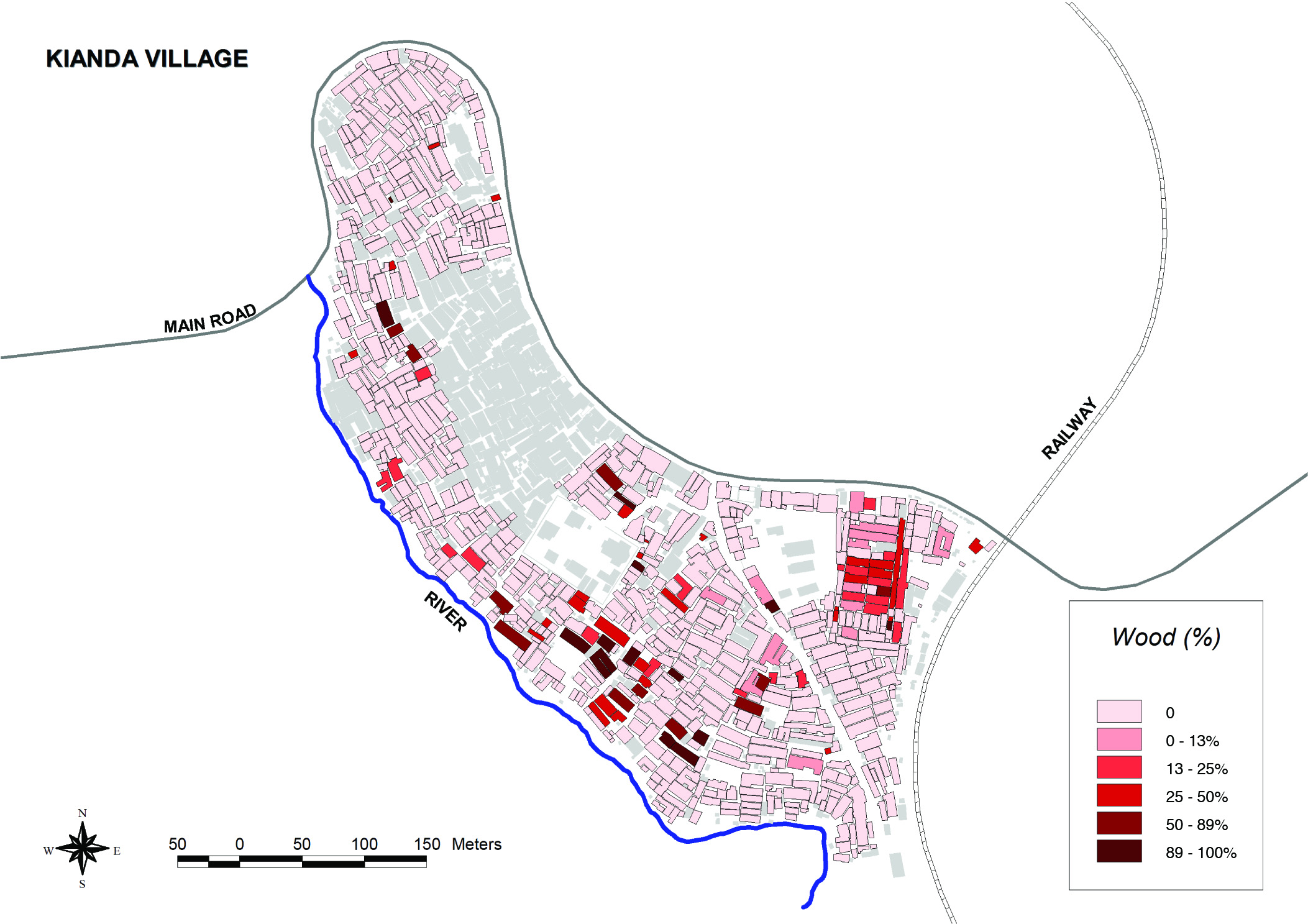
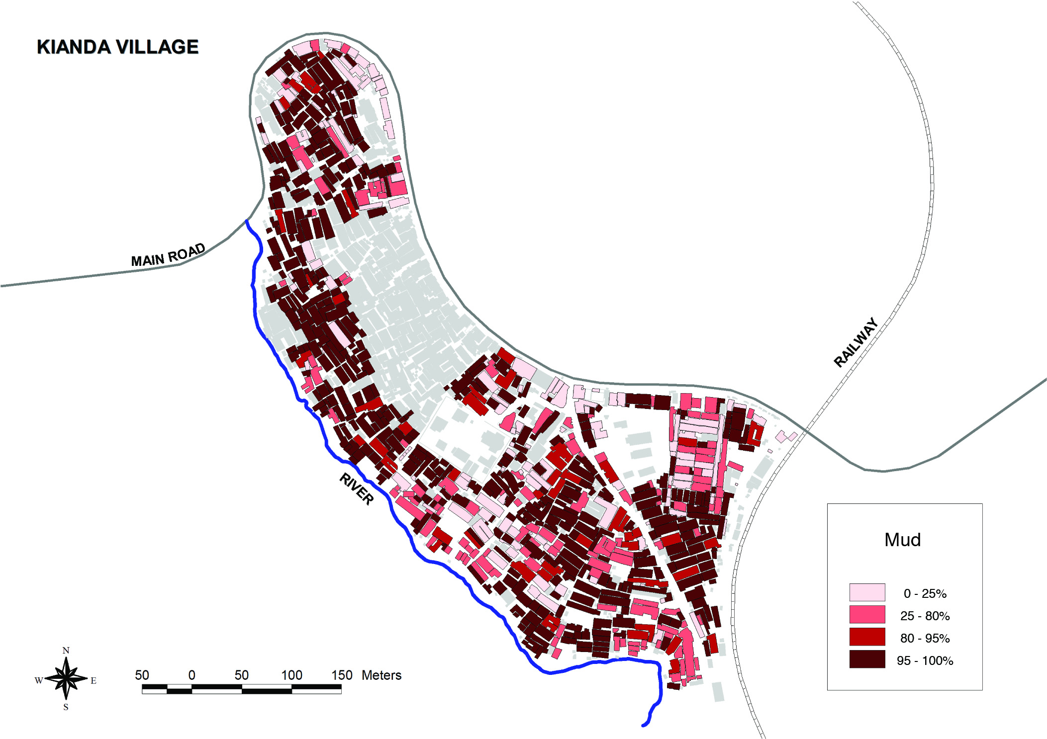
MKP appears to have conducted a more extensive survey of one of the urban villages of Kibera, with fascinating maps of data like building materials, water access points, and toilet locations. It's extremely difficult to map this sort of thing, which is immediately useful for stuff like disaster relief and infrastructure improvement, so great work all around.
posted by theodolite at 10:10 AM on January 18, 2011
posted by theodolite at 10:10 AM on January 18, 2011
The maps of Kianda village are fascinating but one bit has me puzzled. There's a large square on the north edge where the buildings aren't made of mud, iron, wood or concrete, which are pretty much the only choices. Is the survey just incomplete there or is there some other explanation? Puzzles puzzles.
posted by scalefree at 10:37 AM on January 18, 2011
posted by scalefree at 10:37 AM on January 18, 2011
@scalefree There are quite a few solid structures and open spaces in Kibera, particularly clinics and churches. What I think you are looking at is St. George's, a church complex also containing a school (that's a common combination)
http://www.openstreetmap.org/browse/node/752496685
http://www.openstreetmap.org/browse/node/612009450
@gadha Thanks for the praise on the ictd presentation. It's true, they don't use maps much now, but we think the potential is huge. Everyone who has seen the end results has come away with a new vision of Kibera.
posted by mikel.maron at 1:01 PM on January 18, 2011
Can you see where Obama was born?
posted by oneironaut at 3:05 PM on January 18, 2011
posted by oneironaut at 3:05 PM on January 18, 2011
No, there's a huge block of buildings along the main road that aren't color tagged in any of the building type maps (concrete, wood, iron or mud). It's a big region that's left out of just that survey but not the others. Having seen the pattern I'm just kind of curious for the reason behind it.
posted by scalefree at 4:59 PM on January 18, 2011
posted by scalefree at 4:59 PM on January 18, 2011
This is wonderful. Understanding why and how people organise their lives in towns like this is really important. Plus I love the "just do it" attitude of projects like these. I hope people make good use of the maps over time - I'm interested to see how this progresses.
posted by harriet vane at 10:42 PM on January 18, 2011
posted by harriet vane at 10:42 PM on January 18, 2011
Great post, Dim Siawns - thanks. I just saw The Constant Gardener for the first time recently, and was fascinated by the open-air theatre/health education show put on by these guys in Kibera as part of the film, so it's interesting to see more about the place.
posted by penguin pie at 12:26 AM on January 19, 2011
posted by penguin pie at 12:26 AM on January 19, 2011
« Older Generation Why? | I hope I can visit them in Belgium or France or... Newer »
This thread has been archived and is closed to new comments
posted by gadha at 10:07 AM on January 18, 2011