New Orleans, debunked
March 22, 2018 1:39 PM Subscribe
Nate Silver: “Although New Orleans has nothing on Venice, which looks like what you'd get if you turned the civil engineering over to a pod of dolphins.”
posted by Huffy Puffy at 2:06 PM on March 22, 2018 [17 favorites]
posted by Huffy Puffy at 2:06 PM on March 22, 2018 [17 favorites]
All those places where the river could have entered the Gulf but didn't: It used to. But then it brought a piece of North America down and dropped it to either side.
And those bridges? No biggie. That water is only a couple feet deep. And that's not even the longest bridge in the area. Just head west on 10 toward Baton Rouge. People gotta get places.
Also, yes, that's a canal. We're not happy about it either.
Finally, those houses... they're called "camps" by the way. Check em out on Streetview.
posted by rlk at 2:17 PM on March 22, 2018 [5 favorites]
Really a lot of his weirdnesses are accounted for by the fact that it’s a terrible place to build a city, but it’s the least terrible place to build a city near enough to the mouth of the Mississippi to serve as a port. The nucleus of the city was on a place that was actually above sea level but it’s grown far beyond that. And in the 300 years (holy shit this year is the tricentennial, now I want to see if I can find an excuse to visit home for the celebrations) since it was founded, people have been doing increasingly larger earthmoving projects to keep the Mississippi in the same course.
Keep the river in one place and it stops depositing new soil all around it’s former delta. Erosion sets in and the above-ground terrain becomes more and more fragmented.
Turning the reasons NOLA is where it is into fantasy stuff is an interesting game. Like, it’s maybe not so important to get river access to the 1/3 of the continent that drains through there any more now that we have highways, but there’s also huge oil deposits out in the Gulf that have become a major chunk of its economy. Make it magical: in the Age of Gods, there was a war that blew out a huge crater that’s filled with water; the bones of dead gods lie deep beneath the muck and have become a resource that modern people covet. But their dormant magic seeps into the ground and makes everything on the coast strange and dangerous. Great excuse to use whatever crazy shit you couldn’t jam into a generic cod-European setting. Maybe you riff on voudoun for your local magic flavor, maybe you do something totally different. Any macguffin you want could be trawled off the Gulf’s floor and show up in Fantasy NOLA - old weapons/tools of the God War that still function in some manner, wish-granting catfish as old as the Gulf, whatever. Maybe one of these is able to let FNOLA launch a major war of conquest, turning it into the Creepy City of the Evil Army the Good Guys have to make their way into so they can take out the Crescent King. Maybe one of them is what lets FNOLA remain the one bastion of freedom in a continent threatened by Lord Orange. Whatever.
Maybe constraining the Fantasissisippii also constrains the Great Sky Serpent, and lets the great Weather Witch-Lord Nashro’ber harness the forces of the regular hurricanes to fuel FNOLA’s powers by regular sacrifices of the citizens of the neighboring citystates. But when he retires, nobody can match his control, and the Sky Serpent finally wreaks its vengeance on the city.
Like, it’s a weird place, USE this, use the weirdness of other places that don’t look like a nice tidy map of Fantasy England in the front of Tolkien, make your fantasy richer and stranger.
posted by egypturnash at 2:28 PM on March 22, 2018 [51 favorites]
Also the reason the river goes all the way out to the very end of the land is that it builds its own banks as it goes. Used to, anyway.
posted by Anticipation Of A New Lover's Arrival, The at 2:28 PM on March 22, 2018 [3 favorites]
posted by Anticipation Of A New Lover's Arrival, The at 2:28 PM on March 22, 2018 [3 favorites]
So, yesterday I was curious about why the Mississippi River is so close to the bluffs at Memphis, so one side of the river is a much higher elevation than the other side. Turns out the low side is floodplain now, and the high side just isn’t floodplain yet. (At geological timescales all is vanity.)
But! This led me to learn about the Mississippi Embayment, which I did not know about and may someday become its own FPP. Did you know that the entire lower Mississippi/Delta south of, like, Illinois was underwater during the Cretaceous period? There was a hot spot when Pangea broke up, it raised up (this is why there are diamonds in Arkansas), then eroded flat. Then when it moved away from the hot spot, the whole area sank and the Gulf of Mexico filled in. And everything from Carbondale to Little Rock to Memphis to all of Louisiana and Mississippi was silted in by the river(s) in the Cenozoic Era. (The bluffs in Memphis appear to be wind blown soil from the ice age, I guess?)
So: Geology wore a big hole in the middle of North America, and the river filled it in.
posted by Huffy Puffy at 2:58 PM on March 22, 2018 [16 favorites]
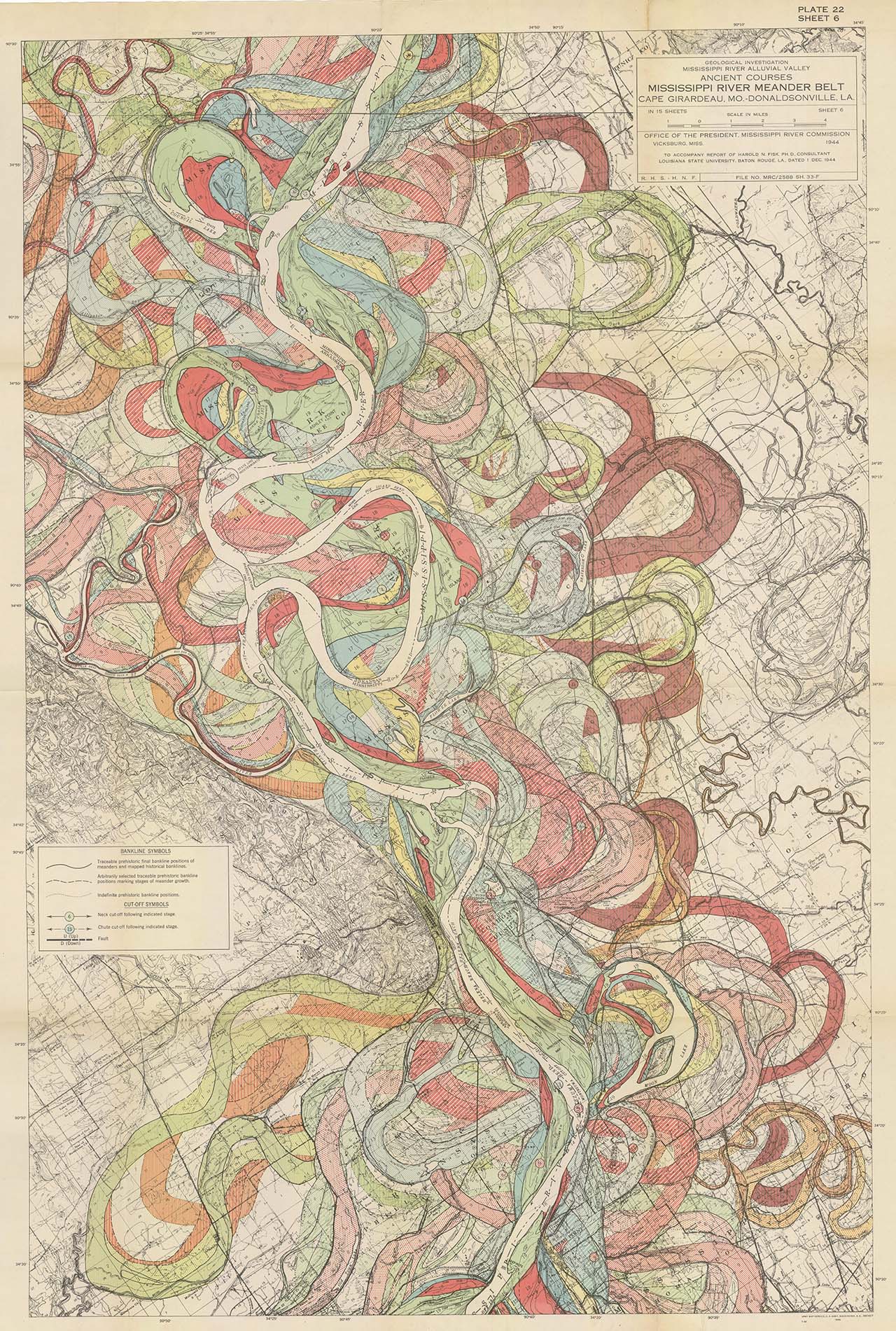
No discussion that includes the Mississippi River is complete without a link to one of the amazing meander maps.
posted by Thorzdad at 3:32 PM on March 22, 2018 [28 favorites]
posted by Thorzdad at 3:32 PM on March 22, 2018 [28 favorites]
“I'm sure there are many more things I could critique, but I don't want to be too harsh. It *is* a really interesting-looking design, but in the end, it's just not believable. (And don't give me your giant document on why it could be this way—we don't have space to print that.)”
I feel attacked
posted by bleep at 3:37 PM on March 22, 2018 [4 favorites]
I feel attacked
posted by bleep at 3:37 PM on March 22, 2018 [4 favorites]
I want fantasy Mardi Gras now, the beads are all enchanted and vanish when the sun comes up. The costumes embody the spirits, and if there aren't enough the spirits roam free. The floats literally float, by way of an unstable alchemical concoction that must be prepared at great expense (but no one would dream of not doing it, that would be ridiculous).
posted by Sebmojo at 3:51 PM on March 22, 2018 [4 favorites]
posted by Sebmojo at 3:51 PM on March 22, 2018 [4 favorites]
I’m pretty sure it’s just Sazerac.
posted by jenkinsEar at 4:10 PM on March 22, 2018 [1 favorite]
posted by jenkinsEar at 4:10 PM on March 22, 2018 [1 favorite]
Wait till they show this guy the Outer Banks...
posted by capricorn at 4:14 PM on March 22, 2018 [2 favorites]
posted by capricorn at 4:14 PM on March 22, 2018 [2 favorites]
to a pod of dolphins
My understanding is that dolphins are hella cool, love to party and really dig a second line, so I'll interpret this as "plausible". Which does, if you reflect on this, offer some hope for the city.
posted by mwhybark at 5:04 PM on March 22, 2018
My understanding is that dolphins are hella cool, love to party and really dig a second line, so I'll interpret this as "plausible". Which does, if you reflect on this, offer some hope for the city.
posted by mwhybark at 5:04 PM on March 22, 2018
So I had other things I wanted to do today but instead I spent a while writing a brief history of The Golden City Of No-lah.
posted by egypturnash at 5:43 PM on March 22, 2018 [14 favorites]
posted by egypturnash at 5:43 PM on March 22, 2018 [14 favorites]
wish-granting catfish as old as the Gulf
You thought that they would grant you your wish, but you were just being... catfished.
posted by Halloween Jack at 6:44 PM on March 22, 2018 [2 favorites]
You thought that they would grant you your wish, but you were just being... catfished.
posted by Halloween Jack at 6:44 PM on March 22, 2018 [2 favorites]
And then there's Boston, which is clearly someone's lazy "I'll redo this later" attempt at procedurally generating streets that somehow made it into the final product.
posted by tobascodagama at 7:22 PM on March 22, 2018 [7 favorites]
posted by tobascodagama at 7:22 PM on March 22, 2018 [7 favorites]
Thorzad.... I feel I need an adult to explain that Meander map..... what the heck are we looking at?
posted by Paladin1138 at 8:42 PM on March 22, 2018
posted by Paladin1138 at 8:42 PM on March 22, 2018
.. what the heck are we looking at? That's where the river used to actually flow at various points in time.
See this for an idea of what it looked like
https://fntest213.files.wordpress.com/2014/12/rcxfvpa.gif
posted by 922257033c4a0f3cecdbd819a46d626999d1af4a at 8:56 PM on March 22, 2018 [4 favorites]
See this for an idea of what it looked like
https://fntest213.files.wordpress.com/2014/12/rcxfvpa.gif
posted by 922257033c4a0f3cecdbd819a46d626999d1af4a at 8:56 PM on March 22, 2018 [4 favorites]
The Meander map is the path that the Mississippi River has taken over thousands (millions?) of years. Over time, rivers change course as the water erodes the surrounding landscape, and builds up silt and debris deposits.
posted by drinkyclown at 8:57 PM on March 22, 2018 [2 favorites]
posted by drinkyclown at 8:57 PM on March 22, 2018 [2 favorites]
River channels move, you are looking at the different paths the river has taken over time.
the maps were made to predict where levees would leak.
Louisiana is geologically unique on the planet earth. There is no other place on the planet were a such a powerful river enters such a gentle sea. The Nile delta makes a similiar landform, but the mississippi river is so strong, it's really is one of a kind.
and the United States treats us like a gas station, instead of an ecological treasure we know it to be.
posted by eustatic at 9:01 PM on March 22, 2018 [16 favorites]
Calling Bays 'Lakes' is a holdover from being part of New France, you all know this, quit acting like you don't.
The river is still building land, and Louisiana is learning to engineer it to build land, here's a flyover of about ~2000 acres built by the ecological restoration program
posted by eustatic at 9:10 PM on March 22, 2018 [3 favorites]
The river is still building land, and Louisiana is learning to engineer it to build land, here's a flyover of about ~2000 acres built by the ecological restoration program
posted by eustatic at 9:10 PM on March 22, 2018 [3 favorites]
The meandering nature of the Mississippi is responsible for the fact that Kaskaskia, once the capital of the pre-state Illinois Territory, is now the sole exception to the state being east of the river.
posted by Halloween Jack at 10:38 PM on March 22, 2018 [3 favorites]
posted by Halloween Jack at 10:38 PM on March 22, 2018 [3 favorites]
Jim's going to be a Guest of Honor at my local science fiction convention on Easter weekend. Can't wait to chat with him about this.
posted by magstheaxe at 7:45 AM on March 23, 2018
posted by magstheaxe at 7:45 AM on March 23, 2018
"Over time, rivers change course as the water erodes the surrounding landscape, and builds up silt and debris deposits."
And the Mississippi more than most, because it's unusually powerful, carries an unusual lot of silt, and traverses unusually flat land with unusually deep bedrock. Along the Mississippi in Illinois, Iowa, and Missouri, the bedrock is typically about 800-1000 feet below the surface. The deepest the Mississippi gets is around 200 feet (but mostly it's 50-100 feet). We know more about the rocks on the moon than the bedrock under Illinois.
So the Mississippi travels a LOT, because it's a very powerful river that carries a SHIT TON of silt that runs off from the incredibly rich surrounding soil (Iowa has around a foot of just topsoil (although half that now where it's been intensively farmed)), deposits it as it goes, and then meanders to the side because the land is SO FLAT and the river has EIGHT HUNDRED FEET OF STUFF to shuffle around before it could find firm bedrock; only a very few places along its course is there rock close enough to the surface to give the Mississippi a permanent direction.
And this is why the Mississippi decides every decade or so to flood surrounding towns like a mofo (it's trying to wander!), and why it has to be constantly attended to to keep the shipping channel clear, and why New Orleans has such crazy-ass river/water/land stuff going on even before you add humans and their industrial works.
And yeah, the Illinois territorial capital in Kaskaskia, which was still an important shipping town, was basically wiped off the map in 1881 when the Mississippi meandered right over it into the tiny Kaskaskia River's channel and flooded the shit out of everyone. It had 7,000 people in it when it was the territorial capital (that was a lot for 1809ish), but every time it gets flooded people leave; there are now just NINE people there. (And preservation of the historical sites there is a huge challenge -- in the 1993 floods the whole town was under 9 feet of water.) I'm looking for a picture of the old channel -- it's a sad little creek now -- I'll post if/when I find one!
posted by Eyebrows McGee at 8:19 AM on March 23, 2018 [11 favorites]
Okay, I could not find good photos but you can actually see quite a bit on Google maps, so I have annotated one for you! If you click on the blue markers there's some commentary. At the top note the narrow channel of the Kaskaskia River. On April 18, 1881, the Mississippi's modern (2018) channel then belong to the Kaskaskia River. The Mississippi swung west of the town, roughly along the red line I've marked (which is roughly the IL/MO border). That wide green valley at the bottom of the loop was the Mississippi channel. Some time in the night, the river swept into the Kaskaskia's channel, flooding the town, tripling the width of the Kaskaskia channel, and leaving the old Mississippi channel almost entirely dry -- look at the picture linked in the marker right by St. Mary, it's barely a creek -- so that on April 19, the peninsula was an island and the Mississippi had moved. If you switch the map to "terrain" view, you can see where the current "Old Mississippi" channel is (probably the deepest part of the river originally) and how teeny that is compared to the obvious old channel. Also note the very beige farm fields compared to the much greener ones on the sides (and the characteristic veiny pattern of river bluffs along the Mississippi, that's greenery around creeks mostly that are draining runoff down the bluff).
Now that you know what you're looking at and have a great, very clear example from 1881, you can zoom out the map a bit, and CLEARLY see the low flood plain of the river that it's meandered all around for thousands of years, and probably pick out some oxbow lakes and abandoned channels on your own -- more muddled because there's more years since them, but you can see them!
posted by Eyebrows McGee at 9:53 AM on March 23, 2018 [6 favorites]
Also very relevant to this discussion is the Mississippi River Basin Model which was a 200+ acre working scale model of the Mississippi river used to predict flooding.
posted by mmascolino at 10:20 AM on March 23, 2018 [2 favorites]
posted by mmascolino at 10:20 AM on March 23, 2018 [2 favorites]
Thanks, Eyebrows; didn't realize how close Kaskaskia is to I-55, and am now regretting that I didn't take a detour to see what's left when I went down to Memphis a couple of years ago (or during any of my other trips to/from there before).
posted by Halloween Jack at 11:24 AM on March 23, 2018
posted by Halloween Jack at 11:24 AM on March 23, 2018
the beads are all enchanted and vanish when the sun comes up.
What, were they made by the fucking Drow to screw parties out of the treasure they found during the festivities? ragga fraggin Underdark BS..
posted by FatherDagon at 1:01 PM on March 23, 2018 [1 favorite]
What, were they made by the fucking Drow to screw parties out of the treasure they found during the festivities? ragga fraggin Underdark BS..
posted by FatherDagon at 1:01 PM on March 23, 2018 [1 favorite]
I finally visited New Orleans in January of last year. I stopped for a couple of days while driving cross-country to meet my wife in DC for the Women's March. I raved about it so much that she joined me for a second visit in December. My reaction is the opposite of this guy's; the place is just too good to be true.
posted by ogooglebar at 6:40 PM on March 23, 2018
posted by ogooglebar at 6:40 PM on March 23, 2018
Okay, after two hours on google maps and Wikipedia I’m hungry for more but google is failing me. Does anyone have a good recommendation for geographic or geological popular science books of southern Louisiana or Mississippi delta region?
posted by midmarch snowman at 4:29 PM on March 26, 2018
posted by midmarch snowman at 4:29 PM on March 26, 2018
I'd start with The Control of Nature, even though it doesn't cover recent events, because it's John McPhee.
posted by asperity at 6:52 PM on March 26, 2018
posted by asperity at 6:52 PM on March 26, 2018
« Older poppies! poppies! | Look inside your heart, I'll look inside mine Newer »
This thread has been archived and is closed to new comments
posted by Halloween Jack at 1:55 PM on March 22, 2018 [4 favorites]