River Transit Maps
March 19, 2011 9:58 PM Subscribe
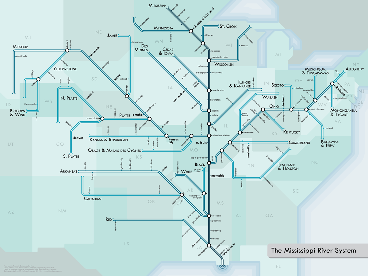
Inspired by Harry Beck's London Underground maps, Daniel Huffman designed a series of stylized river maps for Michigan, North and Central California, Southwest New England, The Colorado River, Columbia River, and The Mississippi River. He also writes about the process he used in creating them.
I know this intellectually but I still can't get my head around the fact that the Mississippi goes from Minneapolis to New Orleans and its drainage area is the entire eastern half of the country.
posted by The Whelk at 10:07 PM on March 19, 2011
posted by The Whelk at 10:07 PM on March 19, 2011
So it's going to take me at least three transfers to get from Bismarck to Pittsburgh?
And how many zones is that? Am I going to get lip from the driver that my transfer's expired?
posted by Capt. Renault at 10:16 PM on March 19, 2011 [3 favorites]
And how many zones is that? Am I going to get lip from the driver that my transfer's expired?
posted by Capt. Renault at 10:16 PM on March 19, 2011 [3 favorites]
The Illinois - Missouri - Mississippi confluence ought to be more - Bank-Mounumenty.
Grafton makes Peoria look like Chicago if you dropped Manhattan into Lake Michigan.
posted by Kid Charlemagne at 10:25 PM on March 19, 2011
Grafton makes Peoria look like Chicago if you dropped Manhattan into Lake Michigan.
posted by Kid Charlemagne at 10:25 PM on March 19, 2011
Transit planning consultant Jarrett Walker has written a few posts about these maps on his blog Human Transit:
What Rivers Teach About Transit
Basics: Branching (or How Transit Is Like a River)
posted by neal at 10:33 PM on March 19, 2011 [1 favorite]
What Rivers Teach About Transit
Basics: Branching (or How Transit Is Like a River)
posted by neal at 10:33 PM on March 19, 2011 [1 favorite]
way cool. I like the "headwaters" and "outflow" graphic elements.
posted by LobsterMitten at 10:44 PM on March 19, 2011
posted by LobsterMitten at 10:44 PM on March 19, 2011
These are great, clicked to buy the Mississippi print, but Zazzle's $55 for an unframed poster is a bit much.
posted by orthogonality at 10:47 PM on March 19, 2011
posted by orthogonality at 10:47 PM on March 19, 2011
I want to show what people who live there call it, what they think of it as being.
Then why the "North" California label?
posted by ActingTheGoat at 10:51 PM on March 19, 2011
Then why the "North" California label?
posted by ActingTheGoat at 10:51 PM on March 19, 2011
On the California map, the Owens and Kern look really lonely out there.
posted by madcaptenor at 10:57 PM on March 19, 2011
posted by madcaptenor at 10:57 PM on March 19, 2011
This is certainly what the internet is for. Cool post.
posted by auto-correct at 11:10 PM on March 19, 2011
posted by auto-correct at 11:10 PM on March 19, 2011
I know this intellectually but I still can't get my head around the fact that the Mississippi goes from Minneapolis to New Orleans and its drainage area is the entire eastern half of the country.
I know, right? I mean, my brain understands that the Appalachians are there, but I kind of want to yell at the Ohio river: "TURN AROUND, THE ATLANTIC'S RIGHT THERE. Or at least Lake Eerie; it's not that polluted."
But the Ohio never listens.
posted by auto-correct at 11:36 PM on March 19, 2011 [1 favorite]
and its drainage area is the entire eastern half of the country.
The Eastern Continental Divide begs to differ -- as does the Great Lakes basin (i.e. the St. Lawrence River divide).
But it is close.
posted by dhartung at 11:37 PM on March 19, 2011
The Eastern Continental Divide begs to differ -- as does the Great Lakes basin (i.e. the St. Lawrence River divide).
But it is close.
posted by dhartung at 11:37 PM on March 19, 2011
I love this, but the New Englander in me is confused as to why it's "Southwest" New England instead of just Southern New England, given that all of MA and RI are represented on the map. The Maine coast may be -called- Down East, but if Providence RI isn't SE New England I'm not sure what is.
...man I miss Del's frozen lemonade.
posted by Earthtopus at 12:01 AM on March 20, 2011
...man I miss Del's frozen lemonade.
posted by Earthtopus at 12:01 AM on March 20, 2011
Awesome. Thanks.
posted by safetyfork at 4:11 AM on March 20, 2011
posted by safetyfork at 4:11 AM on March 20, 2011
Came to say what dhartung said in response to "I know this intellectually but I still can't get my head around the fact that the Mississippi goes from Minneapolis to New Orleans and its drainage area is the entire eastern half of the country." -- there's a teeny-tiny little continental divide just southwest of Chicago, about 12 feet high (literally), which is how engineers in Chicago were able to turn the Chicago River backwards to flow into a canal that connects it to the Mississippi system and continue freely dumping their cholera-infested waste into the river that served as their sewer without it flowing into the lake that served as their drinking-water well.
I'm always surprised by the number of engineers and water/river people not from Chicago who refuse to believe me that the river flows backwards; they insist it's impossible and think I'm making it up!
posted by Eyebrows McGee at 5:40 AM on March 20, 2011 [2 favorites]
I'm always surprised by the number of engineers and water/river people not from Chicago who refuse to believe me that the river flows backwards; they insist it's impossible and think I'm making it up!
posted by Eyebrows McGee at 5:40 AM on March 20, 2011 [2 favorites]
I am looking out the window at one of those Michigan Rivers... it's not that straight.... :-\
This is neat, thanks!
posted by tomswift at 5:46 AM on March 20, 2011
This is neat, thanks!
posted by tomswift at 5:46 AM on March 20, 2011
On the California map, the Owens and Kern look really lonely out there.
Sort of like the Staten Island Railway, right? It fascinates me how cartography's necessary simplifications so thoroughly distort our environment. I imagine if lakes and canals were represented here, they would look a hell of a lot more connected.
Also: hello, Iowa!
posted by kittyprecious at 6:27 AM on March 20, 2011
Growing up in New Orleans I learned to associate "river" with what the Mississippi looks like here -- that is, a mile wide and deep enough for ocean going ships to dock. I am always shocked at what other places are willing to consider a "great river." We have drainage ditches in the medians of thoroughfares bigger than the Rio Grande.
posted by localroger at 6:50 AM on March 20, 2011 [2 favorites]
posted by localroger at 6:50 AM on March 20, 2011 [2 favorites]
I appreciate the graphic nature of this but am a little disappointed in some of his choices. The AuSable River, for example, in Michigan is actually two branches--he selected the north branch for his representation. I feel kind of slighted--I've always preferred to the south branch. Also, if he's going to label it as "Illinois & Kankakee" he should have also mentioned the Des Plaines.
Also the tick marks really bother me. When I was first looking at it I assumed they were major tributaries, not cities. If he was going to show cities he shouldn't attach them to the river. It would have been nicer to cite where the Raccoon River meets the Des Moines River in Iowa as opposed to the somewhat inaccurate placement of the city of Des Moines--which really isn't a river town at all.
But it's art and I suppose he has a license to do it his way.
posted by lester at 7:19 AM on March 20, 2011
>> It would have been nicer to cite where the Raccoon River meets the Des Moines River.
It meets it in the middle of Des Moines.
>> which really isn't a river town at all.
You don't say.
posted by JohnFredra at 7:41 AM on March 20, 2011
It meets it in the middle of Des Moines.
>> which really isn't a river town at all.
You don't say.
posted by JohnFredra at 7:41 AM on March 20, 2011
I should have specified by what I think a river town is--Des Moines doesn't have any major river traffic in terms of commerce. There aren't any commercial docks or wharves in your link--there are some for pleasure craft, but not for barges or paid passenger craft.
All I'm saying is I would have used the tic marks to identify major tributaries without mapping them. I'd use a different font and color to mark significant cities.
posted by lester at 8:35 AM on March 20, 2011
All I'm saying is I would have used the tic marks to identify major tributaries without mapping them. I'd use a different font and color to mark significant cities.
posted by lester at 8:35 AM on March 20, 2011
Brilliant maps but he has moved some things around a bit to make it fit. Minneapolis/St Paul is not northeast of Bismarck, it's southeast. The entire northern run of the Missouri is dropped down a couple hundred miles. I assume that this is to make everything fit and I don't have a problem with his artistic license to do so. But it throws off my sense of direction looking at it.
posted by Ber at 8:44 AM on March 20, 2011
posted by Ber at 8:44 AM on March 20, 2011
I love the Colorado River one, but it would also be nice to see a version that includes all of the canals, tunnels and water projects that reroute the Colorado's water to places it was never intended to go, like the All-American Canal, the Central Arizona Project, and all of the infrastructure that diverts water over the Continental Divide to Colorado's Front Range. That would provide a clearer picture of exactly where it is that this water is going.
posted by heurtebise at 9:42 AM on March 20, 2011 [3 favorites]
posted by heurtebise at 9:42 AM on March 20, 2011 [3 favorites]
Oh, these are fabulous. Thank you so much for posting them! I would totally buy these posters for my office if I had any money. Maybe if I save up for a year or so.
posted by pemberkins at 9:52 AM on March 20, 2011
posted by pemberkins at 9:52 AM on March 20, 2011
I assume that this is to make everything fit and I don't have a problem with his artistic license to do so. But it throws off my sense of direction looking at it.
Well, precisely. The purpose of thematic mapping is to privilege one sort of information (in this case, the relative order of settlements--upstream to downstream--along a watercourse) over others (such as true direction between any two locations). Most subway maps are similarly distorted: using the DC Metro map alone, you wouldn't know that to get somewhere halfway between Dupont Circle and Columbia Heights, your best bet would be to get off at the U St station. But it is. Street maps will show you that.
posted by kittyprecious at 11:28 AM on March 20, 2011
On the California map, the Owens and Kern look really lonely out there.
Yeah, that is the thing that bothers me the most about these maps: they don't really represent hydrology systems. It's not like the Kern and the Owens just stop: they're both diverted and/or channelized, and the Owens ends in a lake.
I understand he was looking at this from a transit perspective and not an ecological one. Rivers are systems with inputs and outputs though: at least visually define a proper end to those that don't reach the sea. If you're looking at a river from a transit perspective, I think it's important to be cognizant of the direction of those flows, and showing that a river terminus is a lake or former lake works within the theoretic constraints of the map.
posted by oneirodynia at 11:33 AM on March 20, 2011
... and yes, I can see that there's a symbol for the river's source at one end (which also irks me, because rivers don't just well up at one single spot, but I can put that aside) but it just looks at the other end like [proposed extension coming 2015] should be there.
Anyway, it's an interesting idea and he follows his own internal logic carefully. Like every map, it is notable for what it doesn't show. The thing about transit maps is that there are definite beginnings and ends. Even with the problematic Vignelli Subway map, you can argue that it represents the complete system under a very specific set of criteria. That doesn't really work for hydrological systems where the source of a river is really dozens of feeder creeks throughout the watershed; and where it's "end" is really a shift from a river to irrigation canals, underground culvert, marsh, or covered reservoir.
posted by oneirodynia at 11:49 AM on March 20, 2011
It looks like some navigable rivers and canals were omitted. I'm not sure why exactly - the only criterion listed on the page is that the rivers are "important" to the watershed.
Since these are styled after transport maps, it would be nice if it included all navigable rivers and canals, even the old/obsolete ones like the Erie Canal. You could see the route taken by various cargo and passenger ships over the years.
A large map centered around the Mississippi and great lakes would be interesting. The Mississippi river map would need the canals around Chicago, and the Des Plaines river, that connect Lake Michigan to the Mississippi. Then, the designer would have to do the Hudson river and NYS Canal System, and then the St. Lawrence River and Welland Canal...
posted by Pruitt-Igoe at 4:33 PM on March 20, 2011
Related to my comment, I just found worldcanals.com. I'm going to geek out on this for a while.
posted by Pruitt-Igoe at 4:52 PM on March 20, 2011
posted by Pruitt-Igoe at 4:52 PM on March 20, 2011
On the one hand, I really appreciate this as a mapping exercise. It forces you to see the river system in a different way, and that's always good.
But looking at the basin I know best (the Columbia), he's made some odd choices that add up to a real mischaracterization of the basin. There are small omissions (like leaving out the Umatilla river and a bunch of others, for example) that are probably explainable mostly as design decisions -- once you have chosen a size for the labels, you can only fit in so many details in any one area. The big issues, though, are that there is no indication of the mainstem dams on the Columbia or Snake rivers, and equally no indication of the huge, federally-funded irrigation projects associated with those systems.
That's like having a highway map that leaves off tributary roads and indications of one-way traffic. Leaving the information off the map allows you to have a simple and clean design -- but produces a result that is far more abstracted than just the straightened lines and angles. He's mapping this as if it is a natural system, when in fact it is a human-influenced and -controlled system from top to bottom.
posted by Forktine at 7:04 PM on March 20, 2011
« Older Honneur et Fidélité, Legio Patria... | Such a thing... such an octopus of a thing Newer »
This thread has been archived and is closed to new comments
posted by kittyprecious at 10:05 PM on March 19, 2011