Mapping Manchester (UK)
December 16, 2009 7:19 AM Subscribe
Chris Perkins and Martin Dodge of the Department of Geography, University of Manchester, UK have been scouring archives for maps of Manchester, and have assembled the results in an "intellectually driven" exhibition, Mapping Manchester, at the Rylands Library, Deansgate.
-- Lots of background information, sample maps and links at the project page.
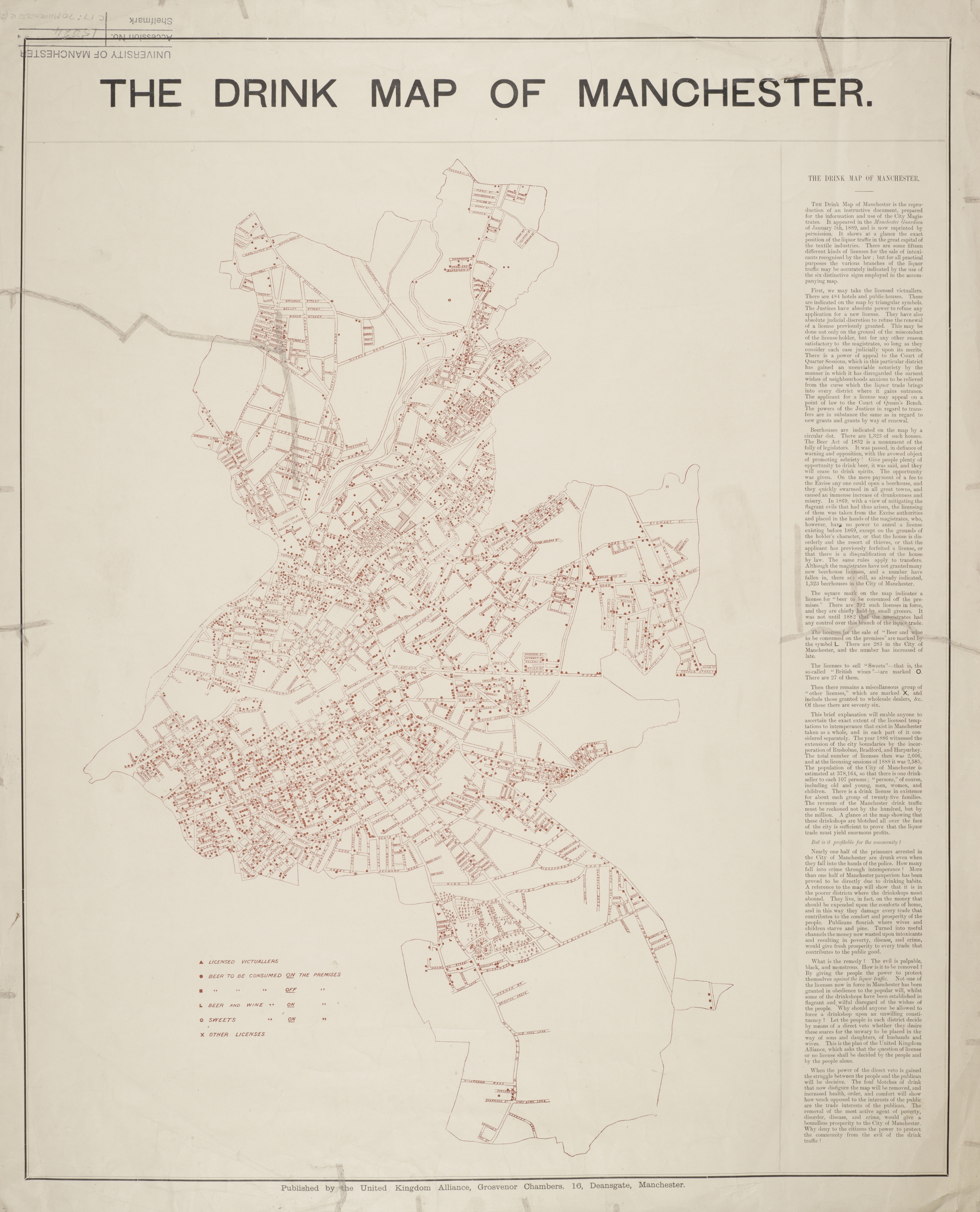
-- Check out oddities like The Drink Map (JPG).
-- Online exhibition pages at the Rylands Library site.
-- Exhibition e-catalogue (PDF)
-- Maps and plans from the History of the Manchester Ship Canal.
And, I learned that denizens of Manchester are called Mancunians. And that the word for a term like Mancunian is "demonym". AKA "gentilic."
-- Lots of background information, sample maps and links at the project page.
-- Check out oddities like The Drink Map (JPG).
-- Online exhibition pages at the Rylands Library site.
-- Exhibition e-catalogue (PDF)
-- Maps and plans from the History of the Manchester Ship Canal.
And, I learned that denizens of Manchester are called Mancunians. And that the word for a term like Mancunian is "demonym". AKA "gentilic."
Nice!
I was a little confused by the symbol for a sweets license in the Drink Map. I was imagining a license for selling mint humbugs and soor plums -- but the key explains this is actually a term for "British wines" (something like sherry, I guess?).
posted by the cat's pyjamas at 8:12 AM on December 16, 2009
So next meetup in 1889 then? Where did I put that DeLorean...
Anyway, I'm off to somewhere very close to one of those dots right now for the office party.
posted by Electric Dragon at 8:29 AM on December 16, 2009
Anyway, I'm off to somewhere very close to one of those dots right now for the office party.
posted by Electric Dragon at 8:29 AM on December 16, 2009
This is ace! really homesick now. And miss the Corn Exchange (in pdf) - anyone else remember the comics and junk and tiedye and !gun stalls. But now we have "the Triangle". the terrorists most definitely won on that one.
also: the John Rylands library is gorgeous and I want to live there, its well worth a visit if you're in town.
and: the noble cause argued on that Drinks Map has, as a quick shuddering glance down Piccadilly when the pubs chuck out will prove, been pretty comprehensively lost.
posted by runincircles at 10:08 AM on December 16, 2009
Oh, that's interesting. I knew the Victoria Park gates were in Rusholme, but I hadn't clocked that what is now "Rusholme" was then "Victoria Park" - one of the world's first gated communities.
posted by alasdair at 12:15 PM on December 16, 2009
posted by alasdair at 12:15 PM on December 16, 2009
Paddbear, the maps are changed to hide Weatherfield, just as if it was a secret military installation. It's either to keep people out, or to keep people in...
posted by BinaryApe at 3:49 PM on December 16, 2009
posted by BinaryApe at 3:49 PM on December 16, 2009
« Older Sands of time | umop 3pi5dn Newer »
This thread has been archived and is closed to new comments
posted by Phanx at 8:01 AM on December 16, 2009