The Secret Soviet Map of Seattle
June 2, 2018 4:22 PM Subscribe
During the Cold War years, the Soviets ran a secret, massive program that produced a million maps of cities and places around the world. They were remarkably accurate and contained information not found on local maps — like the “explosive devices” factory in Ballard.
Davies says the Soviet mapmakers did make some mistakes — misnamed roads, putting in nonexisting subway sections.
Sounds like they could be copyright traps. Or maybe the CIA knew about this project and was feeding them misinformation, perhaps to ferret out Soviet spies.
posted by TedW at 4:46 PM on June 2, 2018 [3 favorites]
Sounds like they could be copyright traps. Or maybe the CIA knew about this project and was feeding them misinformation, perhaps to ferret out Soviet spies.
posted by TedW at 4:46 PM on June 2, 2018 [3 favorites]
Then there is No. 79, offices for the Republican Party here. In Soviet parlance, it is “Department of the Central Committee of the Republican Party.” They don’t bother to list the offices for the local Democrats.
posted by riruro at 4:51 PM on June 2, 2018 [7 favorites]
posted by riruro at 4:51 PM on June 2, 2018 [7 favorites]
I realize the "nuclear" site the Soviets had on their map of Bellvue was described as the 'office' of Exxon nuclear by the salesman who said the Soviets "nailed it", but if I lived next to it, or worse, worked at the site, I'd arrange for a surreptitious survey for radioactivity.
posted by jamjam at 4:55 PM on June 2, 2018 [3 favorites]
posted by jamjam at 4:55 PM on June 2, 2018 [3 favorites]
Fascinating subject that I'd love to know more about, but good God is that a badly-written article.
Remember, in 1976, we’re still in the Cold War.
Oh are we.
posted by ZaphodB at 5:04 PM on June 2, 2018 [4 favorites]
Remember, in 1976, we’re still in the Cold War.
Oh are we.
posted by ZaphodB at 5:04 PM on June 2, 2018 [4 favorites]
I can see my house from here!
They kinda blew the arterial routing, though. Northgate follows that diagonal there between the corners of Meridian and, uh, Northgate (103rd). And the house dots are a little questionable, frankly.
posted by mwhybark at 5:41 PM on June 2, 2018
They kinda blew the arterial routing, though. Northgate follows that diagonal there between the corners of Meridian and, uh, Northgate (103rd). And the house dots are a little questionable, frankly.
posted by mwhybark at 5:41 PM on June 2, 2018
North Seattle
Central Seattle
South Seattle, including cryillic-font key
All links to framed-style zoomable hi-rez aw3 image assets. Links directly taken from article.
posted by mwhybark at 5:45 PM on June 2, 2018
Central Seattle
South Seattle, including cryillic-font key
All links to framed-style zoomable hi-rez aw3 image assets. Links directly taken from article.
posted by mwhybark at 5:45 PM on June 2, 2018
My lot is on there. I would be really surprised if they were making parts for nukes in Ballard. There was little there besides fishing and related marine industries there and Norwegians are famously pacifist.
posted by Slarty Bartfast at 7:35 PM on June 2, 2018 [2 favorites]
posted by Slarty Bartfast at 7:35 PM on June 2, 2018 [2 favorites]
They got my Cul-de-sac wrong...
Still, super creepy, but, cool.
posted by Windopaene at 7:57 PM on June 2, 2018 [1 favorite]
Still, super creepy, but, cool.
posted by Windopaene at 7:57 PM on June 2, 2018 [1 favorite]
The story appears to provide independent archival confirmation of the weapons-manufacture yard, SB.
"A May 4, 1983, Seattle Times story about Honeywell Marine Systems Division moving from Ballard to the Mukilteo area says the company is a prime contractor for the U.S. Navy’s lightweight torpedoes, working on homing systems. The work was important enough that the facility had 'to maintain security,' the story says."
Does that mean the Soviets thought Honeywell was manufacturing parts in Ballard for tactical nuclear delivery devices such as my just-now-imagined and theoretical cruise torpedo? Seems plausible, actually.
posted by mwhybark at 8:37 PM on June 2, 2018
Unfortunately for one Soviet spy, his conversation with a local about specific buried cables was overheard by a Swedish spy who happened to be on the beach, too, says the story.
just...wow...
posted by nikaspark at 10:57 PM on June 2, 2018 [2 favorites]
just...wow...
posted by nikaspark at 10:57 PM on June 2, 2018 [2 favorites]
This is a pretty good way to learn to "pronounce" Cyrillic!
Davies says he’s been contacted by individuals involved in military operations in Afghanistan. In some cases, the vastly more comprehensive Soviet maps were used by the U.S. in its 2001 invasion.
Nice.
posted by batter_my_heart at 12:11 AM on June 3, 2018 [2 favorites]
Davies says he’s been contacted by individuals involved in military operations in Afghanistan. In some cases, the vastly more comprehensive Soviet maps were used by the U.S. in its 2001 invasion.
Nice.
posted by batter_my_heart at 12:11 AM on June 3, 2018 [2 favorites]
batter_my_heart, what surprises me is how the transliteration of the pronounced English into Cyrillic would have helped anyone from Russia to navigate the U.S.? It says, for example, literally "Saut Senter", so you need to know English first in order to decipher it, therefore the map might as well be in Latin alphabet and English. On the other hand, maybe the Russians were planning to dominate the world benevolently, introducing Cyrillic, but retaining all the original languages.
posted by Laotic at 1:24 AM on June 3, 2018
posted by Laotic at 1:24 AM on June 3, 2018
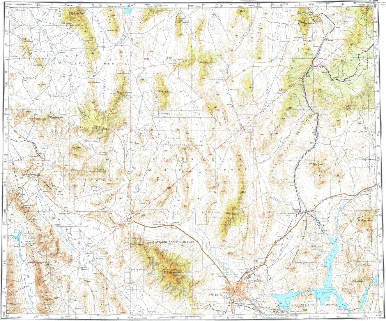
Does anyone know where you could find these of more cities in the US? I was able to find this set of Californian soviet military maps with okay previews on MapStor but the hi-res versions are 1 EUR/ea
They also have Area 51/Vegas
posted by JauntyFedora at 3:03 AM on June 3, 2018
They also have Area 51/Vegas
posted by JauntyFedora at 3:03 AM on June 3, 2018
The merchant that obtained the maps sells them on ebay.
posted by mwhybark at 6:36 AM on June 3, 2018 [1 favorite]
posted by mwhybark at 6:36 AM on June 3, 2018 [1 favorite]
that looked interesting. Too bad the article was behind a pay wall.
posted by james33 at 6:38 AM on June 3, 2018 [1 favorite]
posted by james33 at 6:38 AM on June 3, 2018 [1 favorite]
I found my house!
posted by k8t at 6:56 AM on June 3, 2018 [2 favorites]
posted by k8t at 6:56 AM on June 3, 2018 [2 favorites]
On Meadow Point North of Shilshole marina in Ballard they show a pool. There was a model boat sailing basin there in the 1930's or '40's but it was long gone by 1976.
posted by Mei's lost sandal at 8:39 AM on June 3, 2018
posted by Mei's lost sandal at 8:39 AM on June 3, 2018
When I worked for Yahoo! London back in 2006 they had recently bought a company called Where On Earth who were now operating out of a floor of the London office. Where On Earth were building a geographical database which was eventually released as Yahoo! GeoPlanet. They had filing drawers full of Soviet maps. I don't know how much they used that data.
posted by simonw at 8:41 AM on June 3, 2018 [1 favorite]
posted by simonw at 8:41 AM on June 3, 2018 [1 favorite]
You can see (some of?) the available maps here over on the Red Atlas book website.
posted by motty at 11:41 AM on June 3, 2018 [1 favorite]
posted by motty at 11:41 AM on June 3, 2018 [1 favorite]
I did some GIS stuff for the Norwegian military in the 2003 time frame, and the Soviet maps of Afghanistan was leaps and bounds ahead of anything else we could source. It was a bit surreal working with those maps only about 12 years after the Soviet Union collapsed.
About the same time there was a bit of an outcry in the press when we discovered that Soviet maps of Norwegian harbours were more detailed than the ones we had ourselves.
posted by Harald74 at 3:50 AM on June 4, 2018
About the same time there was a bit of an outcry in the press when we discovered that Soviet maps of Norwegian harbours were more detailed than the ones we had ourselves.
posted by Harald74 at 3:50 AM on June 4, 2018
« Older Approaches to Metered Verse | Same as it ever was, but different again Newer »
This thread has been archived and is closed to new comments
posted by saladin at 4:35 PM on June 2, 2018 [1 favorite]