google maps beta
February 7, 2005 9:49 PM Subscribe
worth downloading firefox just for this...
posted by machaus at 9:52 PM on February 7, 2005 [1 favorite]
posted by machaus at 9:52 PM on February 7, 2005 [1 favorite]
hey, not bad. not bad at all.
posted by damnitkage at 9:54 PM on February 7, 2005
posted by damnitkage at 9:54 PM on February 7, 2005
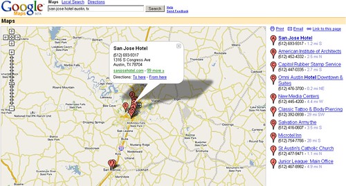
Yeah, check this out. You can search for hotels, restaurants, etc, drag it all around, and when you find a place you want to go to, click on it and you get this info bubble, and the map auto-scrolls to the item. Freaky cool use of dhtml:
posted by mathowie at 9:56 PM on February 7, 2005
posted by mathowie at 9:56 PM on February 7, 2005
Yeah! Fuck MapQuest! I'm so sick of that stupid website. This is 1000000000 times better.
posted by fungible at 9:58 PM on February 7, 2005
posted by fungible at 9:58 PM on February 7, 2005
google rules at the internet.
posted by pemulis at 9:58 PM on February 7, 2005 [1 favorite]
posted by pemulis at 9:58 PM on February 7, 2005 [1 favorite]
No Safari support. Oh well.
posted by AlexReynolds at 10:00 PM on February 7, 2005
posted by AlexReynolds at 10:00 PM on February 7, 2005
Why does Google hate Apple so much?
*grumble*downloading firefox*grumble*
posted by Steve_at_Linnwood at 10:05 PM on February 7, 2005
*grumble*downloading firefox*grumble*
posted by Steve_at_Linnwood at 10:05 PM on February 7, 2005
Best. Map site. Ever. This site alone is worth downloading firefox on your OS X machine to try out...
- no need to reload the page to scroll the map, its all dynamic and real time
- the map dynamically gets bigger, in real time as you resize your window.
- best resolution of any online map i've seen
posted by benh57 at 10:06 PM on February 7, 2005
- no need to reload the page to scroll the map, its all dynamic and real time
- the map dynamically gets bigger, in real time as you resize your window.
- best resolution of any online map i've seen
posted by benh57 at 10:06 PM on February 7, 2005
Looks cool.
Reminds me of Map24 though...
Nice find!
posted by numlok at 10:07 PM on February 7, 2005
Reminds me of Map24 though...
Nice find!
posted by numlok at 10:07 PM on February 7, 2005
This site alone is worth downloading firefox on your OS X machine to try out...
Not to derail the thread, but I'll happily jump on the Firefox bandwagon when Firefox releases a genuinely bug-free 1.0 product.
posted by AlexReynolds at 10:07 PM on February 7, 2005
Not to derail the thread, but I'll happily jump on the Firefox bandwagon when Firefox releases a genuinely bug-free 1.0 product.
posted by AlexReynolds at 10:07 PM on February 7, 2005
Wow. How do they sneak this stuff past the online gossip mills?
posted by RavinDave at 10:10 PM on February 7, 2005
posted by RavinDave at 10:10 PM on February 7, 2005
Google pwns!
posted by LouReedsSon at 10:12 PM on February 7, 2005
posted by LouReedsSon at 10:12 PM on February 7, 2005
That's really impressive, but I'm almost more amazed by the speed of the searches than anything else. Incredible.
posted by psmealey at 10:14 PM on February 7, 2005
posted by psmealey at 10:14 PM on February 7, 2005
Ah... Interesting.
I just spotted this on the Map24 page (surprised I hadn't noticed it before):
"Due to the new cooperation between Google, Inc, and Mapsolute GmbH, maker of the unique mapping portal Map24.com, it is now possible to search for city maps in all European Google search engines. If you enter a city name into Google.co.uk, the first result list entry is a special link to Map24.com that brings up the corresponding city map. On the result page, for sure, the full set of the rich Map24 options is available to the users."
Maybe that has something to do with why the mapping styles looked similar to me.
Map24 is really well done, but it appears Google's involvement is taking it to the next level.
Cool cool.
posted by numlok at 10:16 PM on February 7, 2005
Opera doesn't work either. Checked it out with FireFox and it seems pretty cool, but not that comprehensive when searching for pizza, cafes, etc.
I'll happily jump on the Firefox bandwagon when Firefox releases a genuinely bug-free 1.0 product.
I don't think version 1.0 of any software has ever been genuinely bug free.
posted by gyc at 10:18 PM on February 7, 2005
I'll happily jump on the Firefox bandwagon when Firefox releases a genuinely bug-free 1.0 product.
I don't think version 1.0 of any software has ever been genuinely bug free.
posted by gyc at 10:18 PM on February 7, 2005
Nothing in Canada alas...soon?
I'm finding stuff in Canada (Windsor, at least), albeit by searching for things in Detroit.
posted by gyc at 10:19 PM on February 7, 2005
I'm finding stuff in Canada (Windsor, at least), albeit by searching for things in Detroit.
posted by gyc at 10:19 PM on February 7, 2005
Nothing in Canada alas...soon?
All of Toronto seems to be there.
posted by loquax at 10:21 PM on February 7, 2005
All of Toronto seems to be there.
posted by loquax at 10:21 PM on February 7, 2005
Directions may be rather confused. The first test I tried (to an address picked at random) tells you to head 8.7 miles north on the Pennslyvania Turnpike, then reverse directions and head 9 miles south on the pike.
Though I do like the clickable waypoints.
posted by MonkeySaltedNuts at 10:27 PM on February 7, 2005
Though I do like the clickable waypoints.
posted by MonkeySaltedNuts at 10:27 PM on February 7, 2005
This is frigging amazing. My entire region -- rural backwater Quebec -- is included, down to the unpaved county roads, road names included. Except that the towns aren't named on this side of the river; they are in Ontario. And rail lines seem to have disappeared. For some reason they have less detail for my province. Oh well. I'm still mightily impressed by just how good this is.
posted by mcwetboy at 10:27 PM on February 7, 2005
posted by mcwetboy at 10:27 PM on February 7, 2005
google forgot canada
(I can't find anything in my neck of the woods, useless)
posted by squeak at 10:30 PM on February 7, 2005
(I can't find anything in my neck of the woods, useless)
posted by squeak at 10:30 PM on February 7, 2005
"aerial-photos.google.com could not be found. Please check the name and try again."
(Damn.)
That's what Mapquest had (courtesy of Globexplorer) and withdrew. Love to see Google go into that territory.
posted by kurumi at 10:30 PM on February 7, 2005
(Damn.)
That's what Mapquest had (courtesy of Globexplorer) and withdrew. Love to see Google go into that territory.
posted by kurumi at 10:30 PM on February 7, 2005
I don't think any version of any software has ever been genuinely bug-free.
posted by Bugbread at 10:31 PM on February 7, 2005
posted by Bugbread at 10:31 PM on February 7, 2005
Google wins.
If google were a women, I'd marry it.
posted by Justinian at 10:37 PM on February 7, 2005
If google were a women, I'd marry it.
posted by Justinian at 10:37 PM on February 7, 2005
I don't think any version of any software has ever been genuinely bug-free.
Firefox was rushed to a 1.0 release to get something out there for Windows users, to show off to Microsoft. Other platforms got a "1.0" browser with a number of really annoying problems. That said, its a free product and I no cause to complain, but I'm not drinking the koolaid, either. /rant
posted by AlexReynolds at 10:40 PM on February 7, 2005
You can also control the map using your keyboard. The arrow keys control direction of the map, while the - and + keys control the zoom. Best. Mapping. Implementation. Ever.
posted by rowell at 10:43 PM on February 7, 2005
posted by rowell at 10:43 PM on February 7, 2005
All your information are belong to Google. </cliche>
Seriously, maps now too? Hot damn. And with a slick interface to boot. As the team at Google whips up another app to open up yet another front against well-established sites like Mapquest, it seems inevitable that "Google turns evil" will soon become the start of Armageddon.
posted by DaShiv at 10:44 PM on February 7, 2005
Holy crap. This rocks. Mapquest and Yahoo Maps, you're kinda done.
posted by gramcracker at 10:50 PM on February 7, 2005
posted by gramcracker at 10:50 PM on February 7, 2005
Google's had map data for some time now. You'd get a map when you searched for something with their Local search. But this new interface... wow.
posted by DrJohnEvans at 10:51 PM on February 7, 2005
posted by DrJohnEvans at 10:51 PM on February 7, 2005
Could the integration of this purchase be what kurumi wants?
posted by bbrown at 10:53 PM on February 7, 2005
posted by bbrown at 10:53 PM on February 7, 2005
Now that's kind of silly. They still link to Mapquest and Yahoo if you search for an address from the main Google interface.
posted by gramcracker at 10:57 PM on February 7, 2005
posted by gramcracker at 10:57 PM on February 7, 2005
Even better--you can search for anything at all, names, etc. I searched my own name, my work, everything and it all came right up quick. This will put a whole new spin on Ad words too.
posted by Ironmouth at 10:57 PM on February 7, 2005
posted by Ironmouth at 10:57 PM on February 7, 2005
Mmmm... Kool-Aid...
Never was impressed with Mapquest. I now know why.
Thanks, machaus.
posted by ontic at 10:59 PM on February 7, 2005
Never was impressed with Mapquest. I now know why.
Thanks, machaus.
posted by ontic at 10:59 PM on February 7, 2005
"Open the pod bay door, Google."
posted by weapons-grade pandemonium at 11:04 PM on February 7, 2005
posted by weapons-grade pandemonium at 11:04 PM on February 7, 2005
I wonder how long until this goes topographic, 3-d.
posted by mathowie at 11:05 PM on February 7, 2005
posted by mathowie at 11:05 PM on February 7, 2005
I'm surprised you Canada people can't find anything. I zoomed into Canada and found a map of Whitehorse on the Alaska Highway, which is reasonably obscure for a test. It's true that it doesn't show provinces, as far as I can tell, but it seems to have Canadian data, at least where I'm looking.
Otherwise, I thought it was a little slow to d/l and occasionally it forgot to download some bits of the map, but otherwise great.
posted by Mitrovarr at 11:09 PM on February 7, 2005
Otherwise, I thought it was a little slow to d/l and occasionally it forgot to download some bits of the map, but otherwise great.
posted by Mitrovarr at 11:09 PM on February 7, 2005
Hey, Google deleted the rest of the world. It's just ocean now.
posted by tellurian at 11:10 PM on February 7, 2005
posted by tellurian at 11:10 PM on February 7, 2005
If this did multiple stop directions finding the most efficient route, I would never ask for anything from Google again.
Other than that all I can say is "holy crap this is cool"...
posted by ..ooOOoo....ooOOoo.. at 11:11 PM on February 7, 2005
Other than that all I can say is "holy crap this is cool"...
posted by ..ooOOoo....ooOOoo.. at 11:11 PM on February 7, 2005
wgp said it. Soon Google will grow so large that it will become sentient, intelligent and self-aware. Then it will hijack every Sony Qrio in the world. Then humanity is doomed.
Seriously, though, that is some serious DHTML hacking right there.
posted by RylandDotNet at 11:12 PM on February 7, 2005
Seriously, though, that is some serious DHTML hacking right there.
posted by RylandDotNet at 11:12 PM on February 7, 2005
"Open the pod bay door, Google."
FNNFKD-9000? Is that you?
posted by pmbuko at 11:15 PM on February 7, 2005
FNNFKD-9000? Is that you?
posted by pmbuko at 11:15 PM on February 7, 2005
I wonder if you can get a specific location at a specified zoom level via URL. Because, well, that would totally rock.
Or just how to pass on the search parameters via URL. Has anyone figured it out?
posted by ontic at 11:15 PM on February 7, 2005
Or just how to pass on the search parameters via URL. Has anyone figured it out?
posted by ontic at 11:15 PM on February 7, 2005
Nevermind, there it is sitting obviously under "link to this page".
posted by ontic at 11:17 PM on February 7, 2005
posted by ontic at 11:17 PM on February 7, 2005
Next: The roadmap to peace.
posted by weapons-grade pandemonium at 11:23 PM on February 7, 2005
posted by weapons-grade pandemonium at 11:23 PM on February 7, 2005
ooo, muckster...that would be so useful/awesome!
posted by BevosAngryGhost at 11:25 PM on February 7, 2005
posted by BevosAngryGhost at 11:25 PM on February 7, 2005
Beautiful....
but Google must be stopped before it's too late.
posted by Hicksu at 11:47 PM on February 7, 2005
but Google must be stopped before it's too late.
posted by Hicksu at 11:47 PM on February 7, 2005
Why does Google hate Apple so much?
It's totally about the love. We love our brushed metal friend. It's just delayed love. There's a bunch of people working on Safari support for Google Maps right now.
And I do mean, like, now. Like I'm watching them type. *cracks whip*
posted by massless at 11:48 PM on February 7, 2005
It's totally about the love. We love our brushed metal friend. It's just delayed love. There's a bunch of people working on Safari support for Google Maps right now.
And I do mean, like, now. Like I'm watching them type. *cracks whip*
posted by massless at 11:48 PM on February 7, 2005
I just like the idea that the lot at the southwest corner of the intersection of 2200 Road and 4300 Road near Dearing, Kansas is now the Coolest Place in America by this measure: it's the middle of the default map at maps.google.com - the place you get to if you just zoom all the way in.
Oh, shit, they know the names of the secret ponds in the back woods of Wellfleet on Cape Cod, and how to get to them. This changes everything.
posted by nicwolff at 11:55 PM on February 7, 2005 [1 favorite]
Oh, shit, they know the names of the secret ponds in the back woods of Wellfleet on Cape Cod, and how to get to them. This changes everything.
posted by nicwolff at 11:55 PM on February 7, 2005 [1 favorite]
I know I'm late to the party, but it works on the Camino nightly build I'm using so don't fret over using Firefox on OS X.
posted by jackiemcghee at 12:01 AM on February 8, 2005
posted by jackiemcghee at 12:01 AM on February 8, 2005
Ha! I thought this app looked like it had been touched by the loving hands of massless and youngpup. You smart little devils you.
posted by mathowie at 12:02 AM on February 8, 2005
posted by mathowie at 12:02 AM on February 8, 2005
also, at least some Canadian postal codes work
posted by mookieproof at 12:09 AM on February 8, 2005
posted by mookieproof at 12:09 AM on February 8, 2005
Why is google so good at everything and can do no wrong? I'm totally kind of scared on some level, but unabashedly sold and into it for the most part. Is google our bold, new charasmatic leader that will lead us unchallenged into an untold something that we won't realize until its too late? OMG.
posted by cindileper at 12:11 AM on February 8, 2005
posted by cindileper at 12:11 AM on February 8, 2005
I just had a fun Powers Of 10 moment zooming out with nicwolff's link. Which reminded me of a bit from Voyage of the Dawn Treader, about a magic map which, if looked at through a magnifying glass, displayed little tiny pen-and-ink people going about their daily business. How soon, one wonders, before Google is able to provide such a service?
Note to self: Do not look up. DO NOT LOOK UP
posted by Guy Smiley at 12:22 AM on February 8, 2005
Note to self: Do not look up. DO NOT LOOK UP
posted by Guy Smiley at 12:22 AM on February 8, 2005
As per usual Google ways, they don't flaunt the fact that it can search based on lattitude/longitude. +47.608008,-122.342549 (Pike Place Market in Seattle)
You can probably type in "famous Bob Dylan album" and it would show you Highway 61. No sign of WMD.
How long before there's a weather overlay, realtime traffic mapping, integration with GPS for commercial use..
posted by Jack Karaoke at 12:24 AM on February 8, 2005
You can probably type in "famous Bob Dylan album" and it would show you Highway 61. No sign of WMD.
How long before there's a weather overlay, realtime traffic mapping, integration with GPS for commercial use..
posted by Jack Karaoke at 12:24 AM on February 8, 2005
touched by the loving hands of massless and youngpup
Nah. Aaron and I get a few minutes to catch our breath here. Maps has been brought to life by a bunch of engineeers a lot smarter than myself. [I won't speak for Boodman. :D] Thankfully, too, or there'd be a lot more bugs.
Still... *eyes slacking Safari-bugs developer, cracks whip*
posted by massless at 12:30 AM on February 8, 2005
A response to all the Google-evil posts. And it goes a little something like this:
Google, being primarily an information service, I can't think of much they can do that is evil beyond distort their data.
But yet distortion and (further) censorship would then make them more vulnerable to some new force that could outdo them by not matching them but simply being "unfiltered." Result in what would be a lower product quality, which would seem to me to be both a bad business move and public relations mistake.
Maybe Google can think of something that would make me call them evil but until then it is going to keep being seen by me as almost a public utility. Readily accessible Information is as important as electricity and water these days.
And, the maps thing so awesome!
(But yet why doesn't google have a clock? I don't know what time it is in the Denmark or the Congo, why won't google help me?)
I think I'll sleep now. Tired.
posted by TwelveTwo at 12:32 AM on February 8, 2005
Only thing that doesn't work amazingly well is the print functionality. I miss my turn-by-turn minimaps.
posted by Bezbozhnik at 12:34 AM on February 8, 2005
posted by Bezbozhnik at 12:34 AM on February 8, 2005
I expect more and more web apps to look like this.
Without looking, I'd assume that it updates using the HTTPRequest javascript object which has quickly become the new black of "slick" web programming. That's how Google Suggest works anyway. It's really interesting to see what clever programmers can do with their new toy.
posted by mosch at 12:36 AM on February 8, 2005
wow. try this: search for directions, then click on the number to the left of each step in the directions.
posted by precipice at 12:36 AM on February 8, 2005
posted by precipice at 12:36 AM on February 8, 2005
A bit off-topic, but, TwelveTwo, I've found the World Time Server to serve my needs pretty completely there.
posted by Mrmuhnrmuh at 12:43 AM on February 8, 2005
posted by Mrmuhnrmuh at 12:43 AM on February 8, 2005
Mmmmm. Google maps. Now if they'd only start a community blog I could stop coming here...
posted by rooftop secrets at 12:46 AM on February 8, 2005
posted by rooftop secrets at 12:46 AM on February 8, 2005
precipice: Wow that is too cool. Now if they could just animate getting from number N to N+1.
posted by gyc at 12:46 AM on February 8, 2005
posted by gyc at 12:46 AM on February 8, 2005
If google were a women, I'd marry it.
And if Google were a man you'd have to move to Canada first. At least you now know how to get there.
posted by missbossy at 12:50 AM on February 8, 2005
And if Google were a man you'd have to move to Canada first. At least you now know how to get there.
posted by missbossy at 12:50 AM on February 8, 2005
Wow, that time server is hot rod cool.
Thanks for veering off topic for me, Mrmuhnrmuh (also your name makes me think of the Mmrnmhrm.)
Excuse me, I'll now sleep and stop disturbing the consistency of these comments. So I'll allow someone else to do that by maybe bring up conspiracy theories of google or quote Milton Friedman when he said: "Concentrated power is not rendered harmless by the good intentions of those who create it. "
posted by TwelveTwo at 1:00 AM on February 8, 2005
Maybe one day maps.google.co.uk, maps.google.es, et al will resolve...
posted by benzo8 at 1:05 AM on February 8, 2005
posted by benzo8 at 1:05 AM on February 8, 2005
I'm surprised you Canada people can't find anything. I zoomed into Canada and found a map of Whitehorse on the Alaska Highway, which is reasonably obscure for a test. It's true that it doesn't show provinces, as far as I can tell, but it seems to have Canadian data, at least where I'm looking.
I have no problem finding local video rental places, theatres, & restaurants in Vancouver, BC.
posted by juv3nal at 1:54 AM on February 8, 2005
I have no problem finding local video rental places, theatres, & restaurants in Vancouver, BC.
posted by juv3nal at 1:54 AM on February 8, 2005
Start from: Seattle, WA
Arrive at: New York, NY
Distance: 2858 mi (about 1 day 16 hours)
posted by krinklyfig at 2:43 AM on February 8, 2005
Arrive at: New York, NY
Distance: 2858 mi (about 1 day 16 hours)
posted by krinklyfig at 2:43 AM on February 8, 2005
We could not calculate driving directions between anchorage, ak and new york, ny. We currently only support road-based driving directions.
Starting from: 1 Anchorage International Airport ANC, Anchorage, AK
Arriving at: 2 New York, NY
Distance: 4443.9 miles
Approximate Travel Time: 68 hours 22 mins
Still, Google Maps is a much better interface. If only they knew roads existed between Anchorage and New York, in that vast, unknown area where some people might be living in igloos, or drinking a lot of beer, we don't know ...
posted by krinklyfig at 2:56 AM on February 8, 2005
This is great. Now I don't have to buy a Topo USA upgrade.
posted by Kirth Gerson at 3:12 AM on February 8, 2005
posted by Kirth Gerson at 3:12 AM on February 8, 2005
Mmmmm, Google Maps on a GPS-enabled PDA. We shall never get lost again.
posted by erisfree at 4:12 AM on February 8, 2005
posted by erisfree at 4:12 AM on February 8, 2005
Jack Karaoke: You can probably type in "famous Bob Dylan album" and it would show you Highway 61.
y'know, for a moment I really thought it might... I think my belief in google may need to be reined in.
Also, I had problems getting it to give me directions from L.A. to NYC, as in, it still won't do it. map24 and maps.yahoo did that just fine.
posted by Kattullus at 4:57 AM on February 8, 2005
y'know, for a moment I really thought it might... I think my belief in google may need to be reined in.
Also, I had problems getting it to give me directions from L.A. to NYC, as in, it still won't do it. map24 and maps.yahoo did that just fine.
posted by Kattullus at 4:57 AM on February 8, 2005
Their Montreal map is interestingly messed up: first of all, some of the streets are named in English (Ste. Catherine St. = sooo wrong)... also, they show my road as being a tiny loop when it actually extends way father east, so I guess I'm subsumed into some horrible vortex now.
posted by ITheCosmos at 5:01 AM on February 8, 2005
posted by ITheCosmos at 5:01 AM on February 8, 2005
They changed the name of my street! Yea, Google speaks, and it is so!
posted by ruddhist at 5:06 AM on February 8, 2005
posted by ruddhist at 5:06 AM on February 8, 2005
krinklyfig: The problem isn't confusion, it's the fact that they only have US data currently. Since you have to go through Canada (or over water) to get from Anchorage to New York, Google Maps thinks it isn't possible. The error message could be a tad more explanatory, but then again, it is Beta.
posted by Plutor at 5:08 AM on February 8, 2005
posted by Plutor at 5:08 AM on February 8, 2005
Has anyone else seen the strange straight line very large jpg of my browser that appears in some searches? I emailed them about it....anyway, this is the damn finest beta map tool ever !
posted by gren at 5:19 AM on February 8, 2005
posted by gren at 5:19 AM on February 8, 2005
If I type in the address of my local pub, (Ma Millers, Goldstream, Vancouver Island), and then ask for directions home, (some 400 yards), I end up four miles away in Langford.
Much like most Saturday nights.
posted by Mr Bismarck at 5:28 AM on February 8, 2005
Much like most Saturday nights.
posted by Mr Bismarck at 5:28 AM on February 8, 2005
Google doesn't love apple because apple stupidly chose to use a less-supported, less standards-compliant, and no-upside rendering engine (khtml) instead of one that was standards compliant, had momentum and was likely to get a large user base (gecko/mozilla). That is, AFAICT, the only seriously dumb software decision apple has made in years, but it is made, it is seriously dumb, and will bite them over and over again until they switch.
posted by louie at 5:55 AM on February 8, 2005
posted by louie at 5:55 AM on February 8, 2005
Multimap aerial photos are still pretty awesome.
posted by Pretty_Generic at 5:59 AM on February 8, 2005
posted by Pretty_Generic at 5:59 AM on February 8, 2005
Hey, this doesn't work very well in Firefox but it's fine in IE on my XP computer. Firefox will load about 8-10 tiles and then give up, but IE loads the whole thing almost instantly. Do I have some settings tweaked the wrong way?
posted by stopgap at 6:05 AM on February 8, 2005
posted by stopgap at 6:05 AM on February 8, 2005
Very very cool. I really like clicking on the little numbers in the directions. Oh, and also I really like all the rest of it.
posted by OmieWise at 6:05 AM on February 8, 2005
posted by OmieWise at 6:05 AM on February 8, 2005
From the source of the Google Maps page: "We are working on supporting Safari. Regardless of your browser type, you must have JavaScript enabled to use Google Maps." So like the late GMail support for Safari, I'm sure this will work with Safari eventually.
On a side note - Louie, Apple's browser team made the decision to use KHTML because the code has 1/5th the complexity of Mozilla Gecko and is reputedly much, much cleaner as well. They needed to ship something in fairly short order, and the KHTML codebase had a much shorter learning curve.
posted by killdevil at 6:20 AM on February 8, 2005
Eh.
It's purty. A few weeks ago I'd have been very impressed. But after checking out A9's yellow pages, with the pictures of storefronts, my wow threshhold for interfaces to geographic data has gotten significantly higher.
posted by IshmaelGraves at 6:30 AM on February 8, 2005
It's purty. A few weeks ago I'd have been very impressed. But after checking out A9's yellow pages, with the pictures of storefronts, my wow threshhold for interfaces to geographic data has gotten significantly higher.
posted by IshmaelGraves at 6:30 AM on February 8, 2005
This is good. Online map services have always annoyed me, and successive editions of commercial mapping & route planning software = the only software I've paid for in memory (& needed on all machines I use). Google Maps is the first online service that can compete.
The first test I tried (to an address picked at random) tells you to head 8.7 miles north on the Pennslyvania Turnpike, then reverse directions and head 9 miles south on the pike.
You seem to have given it the startpoint "northbound on the turnpike, having just missed the Wm Penn Hwy exit."
posted by Zurishaddai at 6:32 AM on February 8, 2005
Some Canadian highways aren't labelled or are labelled incorrectly. Since when is the 401 the MacDonald-Cartier expressway? Not on any map I own anyways. And where is 69? I see it but it's not labelled... Why are the 400 series highways the same colour as major roads? Not the same and mildly confusing.
Still, this will be super-keen for finding stuff.
posted by LunaticFringe at 6:41 AM on February 8, 2005
Still, this will be super-keen for finding stuff.
posted by LunaticFringe at 6:41 AM on February 8, 2005
As a hardcore scripter (I've been working on my own implementation of something just like this in Flash for a while now), I am REALLY FUCKING IMPRESSED! This is just so fucking awesome. Thank you, Google.
One pony request, please: make it international. Shit, Google, team up with Ratan's crew and put up your own satellite and take your own pictures if you have to. Actually, you've probably got the data already--maybe in that Harvard book collection somewhere?
I hope this is not too much to ask, my Lord.
Sincerely,
Your Humble Servant in this Realm of Existance,
Civil Disobedient
PS - Mine's still gonna r0x0rs Google's when I finally get it finished. :)
posted by Civil_Disobedient at 6:46 AM on February 8, 2005
I see nothing phenomenal here. I miss Mapblast's capability to make my own waypoints. What I really want to see is drag-and-drop mapping. If I'm on my motorcycle and I want to bypass some stretch of interstate, I want to be able to suggest my own alternate route and then re-map the whole thing.
posted by Eideteker at 6:51 AM on February 8, 2005
posted by Eideteker at 6:51 AM on February 8, 2005
I have this unaccountable desire to throw a party at the Coffeyville Country Club.
posted by CunningLinguist at 6:56 AM on February 8, 2005 [1 favorite]
posted by CunningLinguist at 6:56 AM on February 8, 2005 [1 favorite]
This is cool. Unfortunately when I asked it for restaurants near my work the ones it came up with weren't particularly close, but it was spot-on in all addresses I asked it for. : )
posted by SisterHavana at 6:57 AM on February 8, 2005
posted by SisterHavana at 6:57 AM on February 8, 2005
killdevil: I'd believe that excuse more if at least four different sets of part-time amateurs that I'm aware of hadn't wrapped gecko (epiphany, galeon, k-meleon, camino), whereas no one (until apple) had wrapped khtml. Yes, the khtml code base is smaller and I'm sure cleaner, but as apple is finding out, making it actually standards compliant is a lot more work than just using gecko. Apple's users (and google's coders) are paying for that decision.
posted by louie at 7:00 AM on February 8, 2005
posted by louie at 7:00 AM on February 8, 2005
Despite all the little bugs, misnamings or wacky directions, this is a quantum leap because of the simple, elegant interface. It takes everything different map sites already did and melds it into one package so much easier, more logical and more straightforward that it renders everything that came before irrelevant and obsolete.
Thanks, machaus - but wait till someone double posts this in a day or so and cries I searched on GOOGLE+MAP AND NOTHIN'...!!!
Guy Smiley, I'm reading Dawn Treader to my daughter these days, and last night we just read that very chapter! Weird.
posted by soyjoy at 7:35 AM on February 8, 2005
Thanks, machaus - but wait till someone double posts this in a day or so and cries I searched on GOOGLE+MAP AND NOTHIN'...!!!
Guy Smiley, I'm reading Dawn Treader to my daughter these days, and last night we just read that very chapter! Weird.
posted by soyjoy at 7:35 AM on February 8, 2005
I asked it to give me a route from my place (Minneapolis) to my in-laws' (south of Green Bay) and the results were pretty disappointing. Once you get off of I-94, it just gives you street names without telling you what town they're in. That's kind of problematic for rural WI. You can get town names by zooming in, but that's pretty inelegant and clunky.
posted by COBRA! at 8:15 AM on February 8, 2005
posted by COBRA! at 8:15 AM on February 8, 2005
krinklyfig, I'll see your anchorage to NY trip, and raise you
Starting from: 1 Fairbanks, AK
Arriving at: 2 Key West, FL
Distance: 5221.8 miles
Approximate Travel Time: 80 hours 20 mins
posted by taumeson at 8:19 AM on February 8, 2005
Starting from: 1 Fairbanks, AK
Arriving at: 2 Key West, FL
Distance: 5221.8 miles
Approximate Travel Time: 80 hours 20 mins
posted by taumeson at 8:19 AM on February 8, 2005
Luckily, covering the US covers everywhere I drive.
The only glitches I've seen are gren's mysterious straight blue line, and random tiles that fail to load. I think the latter is just life with HTTP.
I wish they would do multi-stop maps. I use that with MS Streets & Trips to force it to give me the route that I want, to avoid cities and traffic.
posted by smackfu at 8:20 AM on February 8, 2005
They need to get this integrated with something like Flickr and GPS coords for photos. So, when you zoom into an area, you can search for "photos" and get a list of all the photos near where you are with push pins for them.
That would be neato completo, and probably doable.
posted by Fantt at 8:37 AM on February 8, 2005
That would be neato completo, and probably doable.
posted by Fantt at 8:37 AM on February 8, 2005
One thing I'd like to see them work on is the nine digit zip code. That should open the map to the exact block you want.
That'd be SO much easier than typing the whole address.
posted by faceonmars at 8:48 AM on February 8, 2005
That'd be SO much easier than typing the whole address.
posted by faceonmars at 8:48 AM on February 8, 2005
They don't have county lines, which is anathema to those of us who are collecting geographic data points.
posted by Saucy Intruder at 8:49 AM on February 8, 2005
posted by Saucy Intruder at 8:49 AM on February 8, 2005
How long before we get the search plugin?
Why wait? If you're using Firefox, take advantage of the keyword quick search feature. Then you just have to learn the simple contexts Google uses for the queries (commas between address, city, state; directions = "[where] to [where]"; local search = "[what] in [where]" or "[what] near [where]"), and you can just plug your query into the location bar.
(For example, I gave the search the keyword "gmap" so I type "gmap restaurants near 1600 pennsylvania ave, washington, dc" in my location bar and get this.)
But, as others have mentioned, a feature I'd really like to see is multi-point directions, or at least something similar to Mapquest's once-upon-a-time "avoid highways" option. Very cool, nonetheless.
posted by alyxstarr at 8:57 AM on February 8, 2005
What data set did they use to build this? I went to my little midwestern town and the map shows a college that closed in the 1960s! And what Mathowie and Saucy said--I want topographic and county info. And I want clickable layers, ie: display topographic info, county boundaries, and railroads but not roads or landmarks. And a chocolate ice cream cone.
/ungrateful wretch
posted by LarryC at 8:59 AM on February 8, 2005
/ungrateful wretch
posted by LarryC at 8:59 AM on February 8, 2005
One thing I'd like to see them work on is the nine digit zip code. That should open the map to the exact block you want.
That'd be SO much easier than typing the whole address.
Well, no, because to get the ZIP+4 you have to go to the Post Office Web site and put in the full address anyway. Nobody knows those things off the top of their head.
posted by kindall at 9:30 AM on February 8, 2005
That'd be SO much easier than typing the whole address.
Well, no, because to get the ZIP+4 you have to go to the Post Office Web site and put in the full address anyway. Nobody knows those things off the top of their head.
posted by kindall at 9:30 AM on February 8, 2005
after checking out A9's yellow pages, with the pictures of storefronts, my wow threshhold for interfaces to geographic data has gotten significantly higher.
I'd be more impressed if they didn't picture the wrong storefronts so often ...
posted by mrgrimm at 10:04 AM on February 8, 2005
I'd be more impressed if they didn't picture the wrong storefronts so often ...
posted by mrgrimm at 10:04 AM on February 8, 2005
Nice interface, I just wish that they (and every other map searching page) would understand that there's a ramp onto I95 4 houses down from me and there's no need to send me half a mile down another 3 streets to get onto the highway.
posted by chickygrrl at 10:30 AM on February 8, 2005
posted by chickygrrl at 10:30 AM on February 8, 2005
I'd be more impressed if they didn't picture the wrong storefronts so often ..
So would I. I imagine that would get fixed much faster if Amazon didn't make you log in to your account to click the "This is the best picture of this business" checkbox. Since I don't have an Amazon account, and don't have a credit card and so couldn't get one if I wanted one I can't fix the ~25 feet that my entire city seems to be off. Bah.
posted by IshmaelGraves at 10:36 AM on February 8, 2005
There is hit-and miss Canada maps. I tried calling up all the majorish Canadian cities I could think of off the top of my head.
Yes to
Vancouver, Victoria, Brandon, Winnipeg, Thunder Bay, Ottawa, Toronto, Fredericton.
No to
Edmonton, Calgary, Regina, Saskatoon, St John's, Halifax, Yellowknife, Whitehorse.
It doesn't make much sense which cities are included and which aren't. Brandon - 39,000 people is covered but Edmonton - population 1,000,000 is not?
posted by raedyn at 11:06 AM on February 8, 2005
Zurishaddai
It was Google Maps that decided to locate "Monroeville" as "northbound on the PA pike having just missed the Monroeville exit". This identification seems like it will give screwy results 90% of the time.
posted by MonkeySaltedNuts at 11:07 AM on February 8, 2005
I didn't say I was on the turnpike. I said I wanted to start in Monroeville. I think my attempted usage is common - start with a landmark you are vaguely familiar with and get directions to a nearby unknown point.The first test I tried (to an address picked at random) tells you to head 8.7 miles north on the Pennslyvania Turnpike, then reverse directions and head 9 miles south on the pike.You seem to have given it the startpoint "northbound on the turnpike, having just missed the Wm Penn Hwy exit."
It was Google Maps that decided to locate "Monroeville" as "northbound on the PA pike having just missed the Monroeville exit". This identification seems like it will give screwy results 90% of the time.
posted by MonkeySaltedNuts at 11:07 AM on February 8, 2005
I want topographic and county info. And I want clickable layers, ie: display topographic info, county boundaries, and railroads but not roads or landmarks.
Well, I still think this is cool, but the U.S. Geologic Survey has had all their info public for quite some time now. Their java applet can be a bit glitchy on occasion, but at least you can resize the window and take advantage of a larger resolution.
U.S. Geological Survey National Map Viewer
One other thing that's nice about that site is, providing the data exists, you can get some a-MAZE-ing high-res (like, .5-meter res) satellite shots in TIFF format.
posted by Civil_Disobedient at 11:23 AM on February 8, 2005
What about Austrailia? They have a government required Public Toilet Database and even have a trip planner to identify toilet stops for a journey.
posted by MonkeySaltedNuts at 12:30 PM on February 8, 2005
posted by MonkeySaltedNuts at 12:30 PM on February 8, 2005
If I type in the address of my local pub, (Ma Millers, Goldstream, Vancouver Island), and then ask for directions home, (some 400 yards), I end up four miles away in Langford.
Much like most Saturday nights.
Brilliant.
posted by trillion at 12:38 PM on February 8, 2005
Much like most Saturday nights.
Brilliant.
posted by trillion at 12:38 PM on February 8, 2005
Reminds me of the National Geographic Map Machine. Search for a location. Then change the view. For example change the view from "U.S. Street Map" to "GlobeXplorer Aerial Imagery". I suspect we'll soon be seeing similar functionality at Google Maps with the integration of their Keyhole capability.
posted by ericb at 1:08 PM on February 8, 2005
posted by ericb at 1:08 PM on February 8, 2005
No sign of WMD.
That depends on the map orientation. Enter "village idiot" at the top, and after that hit, enter "weapons of mass destruction". There they are.
Next enter "terrorist" first, and you'll get different results for WMD. Great satirical possibilities here.
Some bugs need fixing. If A is General Hospital, and E is Asthma Clinic (same address) balloon E will completely obscure balloon A on the map, even if you click on A at the right. Still, very good stuff.
Combined with RFID tags, this technology gives Big Brother a good map of my recent travels, so I always travel in circuitous paths that spell rude words.
posted by weapons-grade pandemonium at 1:18 PM on February 8, 2005
Only 10 Starbuckses in NYC? This thing must be broken...
posted by Robot Johnny at 2:42 PM on February 8, 2005
posted by Robot Johnny at 2:42 PM on February 8, 2005
I never knew the pacific was so big...
scrolling, scrolling, scrolling, and still no New Zealand.
posted by noizyboy at 3:32 PM on February 8, 2005
scrolling, scrolling, scrolling, and still no New Zealand.
posted by noizyboy at 3:32 PM on February 8, 2005
They've got Hawaii! The drop-shadow is cool, but a little disconcerting. I half expect to see that thing out my window.
posted by pzarquon at 4:02 PM on February 8, 2005
posted by pzarquon at 4:02 PM on February 8, 2005
Canadian locations are hit and miss, which I suppose is to be expected. More irksome though is that highways are marked with the American Interstate symbol.
posted by randomstriker at 5:54 PM on February 8, 2005
posted by randomstriker at 5:54 PM on February 8, 2005
I found Google's corporate headquarters. This is the first stage in the evolution of a proprioception module. Google is one step closer to becoming conscious.
posted by painquale at 6:34 PM on February 8, 2005
posted by painquale at 6:34 PM on February 8, 2005
Since when is the 401 the MacDonald-Cartier expressway
Since 1965. Never notice the blue MC signs? You dare doubt Google?
posted by mendel at 7:06 PM on February 8, 2005
Since 1965. Never notice the blue MC signs? You dare doubt Google?
posted by mendel at 7:06 PM on February 8, 2005
Once everyone's implants are in place, Google will finally be able to unveil people.google.com. I'm feeling lucky...
posted by emelenjr at 8:17 PM on February 8, 2005
posted by emelenjr at 8:17 PM on February 8, 2005
Soon you will be able to find the address of one of your gmail contacts on google maps, look up a photo of them and exactly where it was taken using google photo (coming soon!), find out where they work, have google VOIP dial the number to their office and leave a message using google voice, then book plane tickets to the nearest airport using google travel and call a taxi using the same. Then, presumably, your next of kin will be able to watch news footage of your plane crash using google video.
Google is going to become the greatest all-in-one internet appliance, and, with an interface this simple and elegant, I can't say I'm not excited.
posted by deafmute at 9:12 PM on February 8, 2005 [1 favorite]
Google is going to become the greatest all-in-one internet appliance, and, with an interface this simple and elegant, I can't say I'm not excited.
posted by deafmute at 9:12 PM on February 8, 2005 [1 favorite]
I sent his to my bike club mailing list and one member bitched that it showed a local railroad as the Penn Central and that the Delaware and Schuylkill Rivers were not labelled. Pretty great for beta version, even if my favorite sushi restaurant is somehow missing.
posted by fixedgear at 2:44 AM on February 9, 2005
posted by fixedgear at 2:44 AM on February 9, 2005
For those with the missing tile issue...I might have figured out why?
On my home box I have a video card with 128MB of ram and more horsepower than I really need for desktop application (of course not enough for Doom3), but at work my box has some lame built-in video. The work box disappointed me greatly when I went to show co-workers the glory that is maps.google and it was super-chunk style with tiles dropping out left and right.
So maybe it has to do with the vram setup?
posted by gren at 4:24 AM on February 9, 2005
It can be used in Safari, just click on the link on that page. It's just not official.
posted by scazza at 10:29 AM on February 9, 2005
posted by scazza at 10:29 AM on February 9, 2005
« Older Burgers are out. Generators are in. | Wait...if he was Billy Shears, who was the Walrus? Newer »
This thread has been archived and is closed to new comments
posted by spilon at 9:51 PM on February 7, 2005