Ordnance Survey Maps - England and Wales, 1842-1952
January 4, 2015 3:30 AM Subscribe
Ordnance Survey Maps - England and Wales, 1842-1952: ‘The most comprehensive, topographic mapping covering all of England and Wales from the 1840s to the 1950s,’ courtesy of the National Library of Scotland. You can browse the maps as individual sheets using a zoomable map of England and Wales; as a seamless zoomable overlay layer on modern Google and OS maps; or as a seamless zoomable layer side-by-side with modern Google and OS maps. Also, Maps of Scotland: ‘Access high-resolution zoomable images of over 91,000 maps of Scotland and beyond.’
Ok, the best bit is the overley toggle, and see what bacame of those old coultry road, and the shape of the fields that have not changed in a hundred year.
posted by thegirlwiththehat at 6:22 AM on January 4, 2015 [1 favorite]
posted by thegirlwiththehat at 6:22 AM on January 4, 2015 [1 favorite]
Awesome. Found the house I was born in, which actually had a workhouse in the next street. Dickensian poverty chic for me surely.
posted by colie at 6:22 AM on January 4, 2015 [1 favorite]
posted by colie at 6:22 AM on January 4, 2015 [1 favorite]
I've used it to confirm that it did, in fact, use to be all fields round here.
posted by sobarel at 6:41 AM on January 4, 2015 [5 favorites]
posted by sobarel at 6:41 AM on January 4, 2015 [5 favorites]
Aaaaaaaaaaaah. There goes my morning. I love old maps. I love maps. I love the history of places. Smush these all together like this and I'm in heaven!
Thanks for the link
posted by Jalliah at 6:58 AM on January 4, 2015 [2 favorites]
Well if you realy want there is the 1911 enciclopedia britannica on Wikipedia as a travel companion...
posted by thegirlwiththehat at 7:05 AM on January 4, 2015
posted by thegirlwiththehat at 7:05 AM on January 4, 2015
I'm sending this to my Dad. Just looked at the house I grew up in, they're still there. Figured out why we'd occasionally receive mail addressed to Pit Cottage, turns out that there used to be a gravel pit next door!
posted by arcticseal at 7:16 AM on January 4, 2015
posted by arcticseal at 7:16 AM on January 4, 2015
Oh man that's high rez. I found a way to overlay the maps on Google satellite maps in the background, but I can't see them except when I zoom. The sat view appears for a second and then the map refreshes and it's covered. Some transparent layers would be awesome. The side-by-side will have to do.
This reminds me of an ancient story I read somewhere or other. It was claimed to be one of the first Sci Fi stories ever written. It was about the level of detail in Ordinance Survey maps. There are two resolutions, 6" per mile (1:10,000), and a more detailed 25" per mile. (1:2500). The story hypothesized increasing demand for more resolution, until the maps became 1:1 scale. When the maps were unrolled to confirm their accuracy, they covered the countryside and blotted out the sun.
posted by charlie don't surf at 7:40 AM on January 4, 2015 [2 favorites]
Oh man that's high rez. I found a way to overlay the maps on Google satellite maps in the background, but I can't see them except when I zoom. The sat view appears for a second and then the map refreshes and it's covered. Some transparent layers would be awesome. The side-by-side will have to do.
There's a slider to manipulate the map's transparency on the left-hand side.
posted by hoyland at 7:42 AM on January 4, 2015
There's a slider to manipulate the map's transparency on the left-hand side.
posted by hoyland at 7:42 AM on January 4, 2015
Just heard back from my Dad:
as you can see it was called fernly pit, and it was still an open pit when we'd bought the derelect cottage, and it was filled in with a lot of old cars and motor cycles , which would be worth a fortune now , then the filling was from the development of the lichfield precinct,
I expect to hear of a 78 year old man excavating the pit any moment now...
Thanks misteraitch!
posted by arcticseal at 7:48 AM on January 4, 2015 [4 favorites]
It's odd seeing the Yorkshire coast in (closer to its) heyday. I was looking for coastal erosion, which is visible in places, as you'd expect, but I wasn't really expecting the pang that accompanied seeing a railway line in Robin Hood's Bay. I walked a chunk of the coastal section of the Cleveland Way last summer and somehow, despite using a building that was clearly an old railway station (on Station Road, naturally) to orient my map, my brain didn't really fill in that there really used to be railway service. (There are lots of bits of the Scarborough-Whitby railway about. We probably should have walked the railway path from Ravenscar (which has a platform, but no station left) to Scarborough rather than sticking to the cliff top. It would have at least been relatively flat. I've never been so happy to see Sea Life as I was that day.)
posted by hoyland at 7:58 AM on January 4, 2015 [4 favorites]
posted by hoyland at 7:58 AM on January 4, 2015 [4 favorites]
charlie don't surf: I suspect you're thinking of Sylvie and Bruno (Vol. 2 Ch. 11) by Lewis Carroll which has that concept in it. Also, there's On Exactitude in Science by Borges which plays with the same idea.
posted by sobarel at 8:01 AM on January 4, 2015 [2 favorites]
posted by sobarel at 8:01 AM on January 4, 2015 [2 favorites]
Thanks hoyland, that didn't look like a slider in my browser. Transparency works great.
On preview: yeah sobarel, I think it is the Lewis Carroll story, just looking at the synopsis. Thanks very much, I have been trying to source this story for years.
posted by charlie don't surf at 8:08 AM on January 4, 2015
On preview: yeah sobarel, I think it is the Lewis Carroll story, just looking at the synopsis. Thanks very much, I have been trying to source this story for years.
posted by charlie don't surf at 8:08 AM on January 4, 2015
I have flown from Bridgenorth (Shropshire) to the sorce of the River Severn. It has been a good journey.
Tomorrow for the section from Bridgenorth down to the sea.
posted by thegirlwiththehat at 8:12 AM on January 4, 2015
Tomorrow for the section from Bridgenorth down to the sea.
posted by thegirlwiththehat at 8:12 AM on January 4, 2015
I love old maps, and this is truly wonderful -- thanks, misteraitch!
posted by languagehat at 8:17 AM on January 4, 2015
posted by languagehat at 8:17 AM on January 4, 2015
What I found surprising is how much the 100 year old map looks like todays map. Thats what I get for living in rural Gloucestershire, I suppose. No surprise most of the stone cottages are still there. There's definitely new buildings around here and those used to be manor houses with fields.
What was a working railway line back then is now a beautiful walking/cycling path through woods. I suppose some would see that as an improvement.
posted by vacapinta at 8:34 AM on January 4, 2015
What was a working railway line back then is now a beautiful walking/cycling path through woods. I suppose some would see that as an improvement.
posted by vacapinta at 8:34 AM on January 4, 2015
OS maps are so very useful when I'm out walking. They show local rights of way, which are paths over private land where the public have access, generally on foot but also sometimes by horse. Bing shows the as an option, here in the UK at least. Unfortunately, the rights of way data wasn't included in the OS Opendata project.
Near to where I live is what is left of the Birmingham Canal Navigations canal system. Using an old OS map, I've walked some of the routes left by the canal system before they were filled in. Some sections have been built over, but in one spot, it's possible to see where the locks would have been, even though it's all covered over with tarmac. The path undulates upwards at regular intervals.
posted by Solomon at 8:43 AM on January 4, 2015
I found the Georgian dower house I used to live in in Yorkshire. There was a hedge maze on the grounds that has since been torn down but is noted on the map. Nostalgia!
posted by immlass at 9:09 AM on January 4, 2015
posted by immlass at 9:09 AM on January 4, 2015
They're neat, but only work because the UK's pretty small. Until I moved somewhere bigger, I couldn't conceive of why anyone would use lat/long instead of metric grids.
There was a community project that did this seamless thing a few years back. I'm glad that OSGB has released their iron grip on mapping in the UK, as getting topo data used to be horrible.
For more scanned map nerdry, McMaster has a whole bunch of WW2 maps. They're not seamless or georeferenced, but they're useful once you can work out the projections. This site can be of some help with that.
posted by scruss at 10:13 AM on January 4, 2015
Oh, wow. I've been using the semi-commercial Old Maps for non-commercial research. It's worth a look, as they have more map dates to choose from. But over the past few years they've become progressively more anal about conditions of use, and their latest change - crippling the zoom beyond an unhelpfully low resolution - has killed its usefulness for me. They're not going to like this.
posted by raygirvan at 1:55 PM on January 4, 2015
posted by raygirvan at 1:55 PM on January 4, 2015
Brilliant! and really idiot proof to use. So many mills in my town that are now just street names...
posted by runincircles at 2:38 PM on January 4, 2015
posted by runincircles at 2:38 PM on January 4, 2015
These are neat.
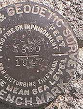
Question: Is a trigonometrical station the same thing as a survey marker/benchmark in the U.S.?
I've never heard them called that here in Idaho (and I do Mounted Orienteering.) I've never seen any here in the U.S. that stuck up out of the ground. Often they are section markers, or parti-section markers, and they are flat, round, metal plates anchored in cement.
posted by BlueHorse at 2:42 PM on January 4, 2015
Fascinating to see the area I lived in without all the motorways.
Also, my road was apparently straightened quite a bit sometime after 1965.
Explains the odd side roads that don't really go anywhere.
posted by madajb at 5:14 PM on January 4, 2015
Also, my road was apparently straightened quite a bit sometime after 1965.
Explains the odd side roads that don't really go anywhere.
posted by madajb at 5:14 PM on January 4, 2015
Also, 7 year old me KNEW that was an old moat near my Nan's house.
Now I've got the 100 year old map to prove it.
Suck it, relatives who said I was imagining things!
posted by madajb at 5:33 PM on January 4, 2015 [2 favorites]
Now I've got the 100 year old map to prove it.
Suck it, relatives who said I was imagining things!
posted by madajb at 5:33 PM on January 4, 2015 [2 favorites]
> Is a trigonometrical station the same thing as a survey marker/benchmark in the U.S.?
Kind of. While they are both known survey points, trig points were usually on top of the highest view point. They had theodolite mounting rails on them, so that the OS could survey from them.
It was always fun to climb up a hill and find a trig point on top. My favourite was (is?) on Bar Hill, as you had to walk past a Roman fort and an Iron Age fort to get to it.
posted by scruss at 6:24 PM on January 4, 2015 [1 favorite]
There are lots of interesting markers, but the type of marker depends when the markers were set. In my state, the first survey markers were from the General Land Office. The area was previously "Indian Territory" and after the Black Hawk War in 1832, the GLO surveyed the land and declared it fit for European settlers and their Manifest Destiny. My university has a huge online catalog of scanned GLO survey maps, but i can't find a darn thing, they're indexed so poorly. Anyway, they laid down stake markers like this which were the grid to lay out townships, counties, and eventually plat maps of new cities. Here is a lonely, worn survey marker in my town, it is claimed to be the Southeast corner of the original plat of the city in 1839. Here is a lovely map of that plat, I used to own one of these maps, it's the first published map of the original town layout, albeit about 15 years later, with some additions and annexes. And with some searching, yes indeed the stone marker can be seen on the original map, marked S.E. Corner Stone, on the corner of Lot #1. Still to this day, in the County Auditor's office, they have original plat books that appear to be mostly based on surveys from 1900.
posted by charlie don't surf at 7:21 PM on January 4, 2015 [2 favorites]
posted by charlie don't surf at 7:21 PM on January 4, 2015 [2 favorites]
« Older Carole King- Library of Congress Gershwin Prize | Preserving Lonesome George Newer »
This thread has been archived and is closed to new comments
It also show that the railway run under the town from North to South, now only the South segment remains. When i was yound i used to wonder along the banks of the river and I once found a walled up tunnel in the green, and i have a vague memory of somebody telling about the colapse of the tunnels under the town, but i always thought they where mines.
Now i know.
I love old maps.
posted by thegirlwiththehat at 6:14 AM on January 4, 2015 [4 favorites]